

File:MODIS Map.jpg
Size of this preview: 640 × 320 pixels.
| |
This is a file from the Wikimedia Commons. Information from its description page there is shown below.
Commons is a freely licensed media file repository. You can help. |
| |
This is a featured picture, which means that members of the community have identified it as one of the finest images on the English Wikipedia, adding significantly to its accompanying article. If you have a different image of similar quality, be sure to upload it using the proper free license tag, add it to a relevant article, and nominate it. |
| |
This image was selected as picture of the day on the English Wikipedia for January 1, 2012. |
Summary
| Description |
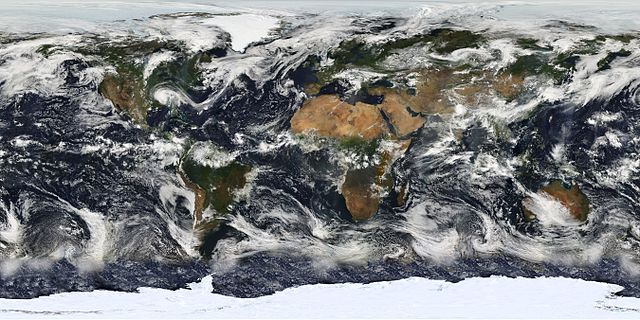
English: Image based largely on observations from the Moderate Resolution Imaging Spectroradiometer (MODIS) on July 11, 2005. Small gaps in MODIS’ coverage between overpasses, as well as Antarctica, have been filled in using GOES weather satellites and the latest version of the NASA Blue Marble.
Français : Planisphère montrant la terre telle qu'elle a été observée par le satellite MODIS le 11 juillet 2005. Les petits trous dans la couveture de MODIS ont été comblés avec des données provenant des satellites GOES, et la dernière version de la Blue marble ( bille bleue) de la NASA.
Italiano: Una foto satellitare della superficie terrestre, elaborata, in larga parte, dalle immagini fornite dalle fotocamere MODIS che equipaggiano i satelliti per telerilevamento Aqua ( EOS PM-1) e Terra (EOS AM-1).
Русский: Изображение, созданное главным образом по данным сканирующего спутникового спектрорадиометра MODIS (2005-07-11.) Небольшие «пропуски» между покрытиями прибора, а также Антарктика, были восстановлены с использованием данных метеоспутников GOES и последней версии « голубого мрамора» NASA.
|
| Date | 11 July 2005 |
| Source | Earth's Vital Signs |
| Author | NASA |
|
 |
This image was selected as picture of the day on Wikimedia Commons for 21 May 2010. It was captioned as follows: English: Image based largely on observations from MODIS.
Česky: Mapa světa složená zejména ze snímků přístrojem MODIS
Dansk: Billede primært dannet af observationer fra et spektroradiometer om bord på Terra-satellitten.
Deutsch: Bild der Erde, zusammengesetzt aus vielen Einzelbildern, überwiegend vom Moderate-resolution Imaging Spectroradiometer
English: Image based largely on observations from MODIS.
Español: Imagen basada en gran parte en observaciones desde el MODIS.
Français : Image basée en grande partie sur des observations avec un MODIS.
Magyar: A földfelszín MODIS (közepes felbontású képalkotó spektrométer) technológiával készített vetületi képe
Italiano: Una foto satellitare della superficie terrestre, elaborata, in larga parte, dalle immagini fornite dalle fotocamere MODIS che equipaggiano i satelliti per telerilevamento Aqua ( EOS PM-1) e Terra (EOS AM-1)
日本語: 地球全体の衛星写真。 MODISの観測を元にしたもの。ただし一部MODISがカバーしない箇所は別のデータを利用している。
한국어: MODIS의 위성 사진을 합성한 지도.
Македонски: Снимка заснована на набљудувањата на сателитскиот инструмент MODIS.
Nederlands: Satellietbeeld van de Aarde, grotendeels samengesteld uit beelden van MODIS-camera's, gemonteerd op de Amerikaanse observatiesatellieten Terra (EOS AM-1) en Aqua (EOS PM-1).
Polski: Obraz powierzchni i atmosfery Ziemi oparty głównie na zdjęciach z przyrządów MODIS satelitów Aqua i Terra.
Русский: Спутниковый снимок, сделанный камерой MODIS
Українська: Зображення поверхні і атмосфери Землі створене переважно зі знімків з супутника НАСА з допомогою спектрорадіометра MODIS 11 червня 2005 року.
中文(简体): 中分辨率成像光谱仪拍摄的照片
中文(繁體): 中解析度成像光譜儀拍攝的地球照片
|
Based on data from the MODIS science team.
Licensing
 |
This file is in the public domain because it was solely created by NASA. NASA copyright policy states that "NASA material is not protected by copyright unless noted". (See Template:PD-USGov, NASA copyright policy page or JPL Image Use Policy.) |
 |
 |
Warnings:
|
File usage
The following pages on Schools Wikipedia link to this image (list may be incomplete):
Learn more about Schools Wikipedia
All five editions of Schools Wikipedia were compiled by SOS Childrens Villages. By supporting vulnerable children right through to adulthood, SOS Childrens Villages makes a lasting difference to the lives of thousands of people. Education is a key part of our work, and our schools provide high-quality teaching to the children in our care. Will you help another child today?
Categories: