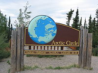
Arctic Circle
About this schools Wikipedia selection
SOS Children volunteers helped choose articles and made other curriculum material See http://www.soschildren.org/sponsor-a-child to find out about child sponsorship.
The Arctic Circle is one of the five major circles of latitude that mark maps of the Earth. It is the parallel of latitude that (as of 2000) runs 66° 33′ 39″ (or 66.56083°) north of the Equator. The region north of this circle is known as the Arctic, and the zone just to the south is called the Northern Temperate Zone. The equivalent latitude in the southern hemisphere is called the Antarctic Circle.
The Arctic Circle marks the southern extremity of the polar day (24 hour sunlit day, often referred to as the "midnight sun") and polar night (24 hour sunless night). North of the Arctic Circle, the sun is above the horizon for 24 continuous hours at least once per year, and below the horizon for 24 continuous hours at least once per year. On the Arctic Circle these events occur, in principle, exactly once per year, at the June and December solstices respectively. It is called the Arctic because it corresponds to the southernmost point of the Constellation Ursa Major (the Great Bear or Megale Arktos in Greek).
In fact, because of atmospheric refraction and because the sun appears as a disk and not a point, part of the midnight sun may be seen on the night of the summer solstice up to about 50 ′ (90 km) south of the Arctic Circle; similarly, on the day of the winter solstice part of the sun may be seen up to about 50′ north of the Arctic Circle. This is true at sea level; these limits increase with elevation above sea level, although in mountainous regions there is often no direct view of the horizon.
The position of the Arctic Circle is not fixed, but varies in a complex manner over time; see circles of latitude for information.
Geography and demographics
The geography north of the Arctic Circle is predominantly ocean, mostly ice-covered, but a great deal of land falls within the Circle as well. The Circle itself passes through eight countries. From the Prime Meridian heading eastwards these are:
- Norway
- Sweden
- Finland
- Russia
- United States – Alaska
- Canada
- Greenland, a territory of Denmark
- Iceland – crosses the island of Grímsey
Very few people live north of the Arctic Circle due to the cold conditions. The three largest communities above the Arctic Circle are situated in Russia; Murmansk (population 325,100), Norilsk (135,000), and Vorkuta (85,000). Tromsø in Norway has about 62,000 inhabitants, whereas Rovaniemi in Finland—which lies slightly south of the line—has slightly fewer than 58,000.
Recently the region north of the Arctic Circle has gained significant international attention due primarily to the perceived threat of global warming. Initial attention came as a result of the fact that the earth's poles are the points at which the planet tends to warm the fastest thereby acting as harbingers of what is to come. The melting of the ice in the Circle is making the Northwest Passage, the shipping routes through the northern-most latitudes, more navigable, raising the possibility that some day the Arctic region could become a prime trade route. In addition it is believed that the Arctic seabed may contain substantial oil fields which may become accessible if the ice covering them melts. These factors have led to recent international debates as to which nations can claim sovereignty or ownership over the waters north of the Circle.


