

Cartesian coordinate system
Background Information
Arranging a Wikipedia selection for schools in the developing world without internet was an initiative by SOS Children. Sponsor a child to make a real difference.


In mathematics, the Cartesian coordinate system (also called rectangular coordinate system) is used to determine each point uniquely in a plane through two numbers, usually called the x-coordinate or abscissa and the y-coordinate or ordinate of the point. To define the coordinates, two perpendicular directed lines (the x-axis, and the y-axis), are specified, as well as the unit length, which is marked off on the two axes (see Figure 1). Cartesian coordinate systems are also used in space (where three coordinates are used) and in higher dimensions.
Using the Cartesian coordinate system, geometric shapes (such as curves) can be described by algebraic equations, namely equations satisfied by the coordinates of the points lying on the shape. For example, the circle of radius 2 may be described by the equation x2 + y2 = 4 (see Figure 2).
History
Cartesian means relating to the French mathematician and philosopher René Descartes (Latin: Cartesius), who, among other things, worked to merge algebra and Euclidean geometry. This work was influential in the development of analytic geometry, calculus, and cartography.
The idea of this system was developed in 1637 in two writings by Descartes and independently by Pierre de Fermat, although Fermat did not publish the discovery. In part two of his Discourse on Method, Descartes introduces the new idea of specifying the position of a point or object on a surface, using two intersecting axes as measuring guides. In La Géométrie, he further explores the above-mentioned concepts.
Two-dimensional coordinate system

A Cartesian coordinate system in two dimensions is commonly defined by two axes, at right angles to each other, forming a plane (an xy-plane). The horizontal axis is normally labeled x, and the vertical axis is normally labeled y. In a three dimensional coordinate system, another axis, normally labeled z, is added, providing a third dimension of space measurement. The axes are commonly defined as mutually orthogonal to each other (each at a right angle to the other). (Early systems allowed "oblique" axes, that is, axes that did not meet at right angles, and such systems are occasionally used today, although mostly as theoretical exercises.) All the points in a Cartesian coordinate system taken together form a so-called Cartesian plane. Equations that use the Cartesian coordinate system are called Cartesian equations.
The point of intersection, where the axes meet, is called the origin normally labeled O. The x and y axes define a plane that is referred to as the xy plane. Given each axis, choose a unit length, and mark off each unit along the axis, forming a grid. To specify a particular point on a two dimensional coordinate system, indicate the x unit first (abscissa), followed by the y unit (ordinate) in the form (x,y), an ordered pair.
The choice of letters comes from a convention, to use the latter part of the alphabet to indicate unknown values. In contrast, the first part of the alphabet was used to designate known values.
An example of a point P on the system is indicated in Figure 3, using the coordinate (3,5).
The intersection of the two axes creates four regions, called quadrants, indicated by the Roman numerals I (+,+), II (−,+), III (−,−), and IV (+,−). Conventionally, the quadrants are labeled counter-clockwise starting from the upper right ("northeast") quadrant. In the first quadrant, both coordinates are positive, in the second quadrant x-coordinates are negative and y-coordinates positive, in the third quadrant both coordinates are negative and in the fourth quadrant, x-coordinates are positive and y-coordinates negative (see table below.)
Three-dimensional coordinate system


The three dimensional Cartesian coordinate system provides the three physical dimensions of space — length, width, and height. Figures 4 and 5 show two common ways of representing it.
The three Cartesian axes defining the system are perpendicular to each other. The relevant coordinates are of the form (x,y,z). As an example, figure 4 shows two points plotted in a three-dimensional Cartesian coordinate system: P(3,0,5) and Q(−5,−5,7). The axes are depicted in a "world-coordinates" orientation with the z-axis pointing up.
The x-, y-, and z-coordinates of a point can also be taken as the distances from the yz-plane, xz-plane, and xy-plane respectively. Figure 5 shows the distances of point P from the planes.
The xy-, yz-, and xz-planes divide the three-dimensional space into eight subdivisions known as octants, similar to the quadrants of 2D space. While conventions have been established for the labelling of the four quadrants of the x-y plane, only the first octant of three dimensional space is labelled. It contains all of the points whose x, y, and z coordinates are positive.
The z-coordinate is also called applicate.
Orientation and handedness
In two dimensions

Fixing or choosing the x-axis determines the y-axis up to direction. Namely, the y-axis is necessarily the perpendicular to the x-axis through the point marked 0 on the x-axis. But there is a choice of which of the two half lines on the perpendicular to designate as positive and which as negative. Each of these two choices determines a different orientation (also called handedness) of the Cartesian plane.
The usual way of orienting the axes, with the positive x-axis pointing right and the positive y-axis pointing up (and the x-axis being the "first" and the y-axis the "second" axis) is considered the positive or standard orientation, also called the right-handed orientation.
A commonly used mnemonic for defining the positive orientation is the right hand rule. Placing a somewhat closed right hand on the plane with the thumb pointing up, the fingers point from the x-axis to the y-axis, in a positively oriented coordinate system.
The other way of orienting the axes is following the left hand rule, placing the left hand on the plane with the thumb pointing up.
Regardless of the rule used to orient the axes, rotating the coordinate system will preserve the orientation. Switching the role of x and y will reverse the orientation.
In three dimensions


Once the x- and y-axes are specified, they determine the line along which the z-axis should lie, but there are two possible directions on this line. The two possible coordinate systems which result are called 'right-handed' and 'left-handed'. The standard orientation, where the xy-plane is horizontal and the z-axis points up (and the x- and the y-axis form a positively oriented two-dimensional coordinate system in the xy-plane if observed from above the xy-plane) is called right-handed or positive.
The name derives from the right-hand rule. If the index finger of the right hand is pointed forward, the middle finger bent inward at a right angle to it, and the thumb placed at a right angle to both, the three fingers indicate the relative directions of the x-, y-, and z-axes in a right-handed system. The thumb indicates the x-axis, the index finger the y-axis and the middle finger the z-axis. Conversely, if the same is done with the left hand, a left-handed system results.
Figure 7 is an attempt at depicting a left- and a right-handed coordinate system. Because a three-dimensional object is represented on the two-dimensional screen, distortion and ambiguity result. The axis pointing downward (and to the right) is also meant to point towards the observer, whereas the "middle" axis is meant to point away from the observer. The red circle is parallel to the horizontal xy-plane and indicates rotation from the x-axis to the y-axis (in both cases). Hence the red arrow passes in front of the z-axis.
Figure 8 is another attempt at depicting a right-handed coordinate system. Again, there is an ambiguity caused by projecting the three-dimensional coordinate system into the plane. Many observers see Figure 8 as "flipping in and out" between a convex cube and a concave "corner". This corresponds to the two possible orientations of the coordinate system. Seeing the figure as convex gives a left-handed coordinate system. Thus the "correct" way to view Figure 8 is to imagine the x-axis as pointing towards the observer and thus seeing a concave corner.
Representing a vector in the standard basis
A point in space in a Cartesian coordinate system may also be represented by a vector, which can be thought of as an arrow pointing from the origin of the coordinate system to the point. If the coordinates represent spatial positions (displacements) it is common to represent the vector from the origin to the point of interest as  . In three dimensions, the vector from the origin to the point with Cartesian coordinates
  is sometimes written as:
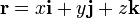
where  ,
,  , and
, and  are unit vectors that point the same direction as the
  ,
,  , and
, and  axes, respectively. This is the quaternion representation of the vector, and was introduced by Sir William Rowan Hamilton. The unit vectors , , and are called the versors of the coordinate system, and are the vectors of the standard basis in three-dimensions.
Applications
Cartesian coordinates are often used to represent two or three dimensions of space, but they can also be used to represent many other quantities (such as mass, time, force, etc.). In such cases the coordinate axes will typically be labelled with other letters (such as m, t, F, etc.) in place of x, y, and z. Each axis may also have different units of measurement associated with it (such as kilograms, seconds, pounds, etc.). It is also possible to define coordinate systems with more than three dimensions to represent relationships between more than three quantities. Although four- and higher-dimensional spaces are difficult to visualize, the algebra of Cartesian coordinates can be extended relatively easily to four or more variables, so that certain calculations involving many variables can be done. (This sort of algebraic extension is what is used to define the geometry of higher-dimensional spaces, which can become rather complicated.) Conversely, it is often helpful to use the geometry of Cartesian coordinates in two or three dimensions to visualize algebraic relationships between two or three (perhaps two or three of many) non-spatial variables.