

Circle of latitude
Did you know...
SOS Children have produced a selection of wikipedia articles for schools since 2005. A quick link for child sponsorship is http://www.sponsor-a-child.org.uk/
 |
|||||||||||||
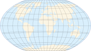
| Map of Earth | |||||||||||||
| Longitude (λ) | |||||||||||||
|---|---|---|---|---|---|---|---|---|---|---|---|---|---|
| Lines of longitude appear vertical with varying curvature in this projection, but are actually halves of great ellipses, with identical radii at a given latitude. | |||||||||||||
| Latitude (φ) | |||||||||||||
| Lines of latitude appear horizontal with varying curvature in this projection; but are actually circular with different radii. All locations with a given latitude are collectively referred to as a circle of latitude. | |||||||||||||
| The equator divides the planet into a Northern Hemisphere and a Southern Hemisphere, and has a latitude of 0°. | |||||||||||||
|
|||||||||||||
A circle of latitude, on the Earth, is an imaginary east- west circle connecting all locations (not taking into account elevation) that share a given latitude. A location's position along a circle of latitude is given by its longitude.
Circles of latitude are often called parallels because they are parallel to each other and an approximately fixed distance apart. On some map projections, including the Mercator projection, they are drawn parallel and at equidistant intervals.
Circles of latitude become smaller the farther they are from the equator and the closer they are to the poles. A circle of latitude is perpendicular to all meridians at the points of intersection, and is hence a special case of a loxodrome.
Contrary to what might be assumed from their straight-line representation on some map projections, a circle of latitude is not, with the sole exception of the Equator, the shortest distance between two points lying on the Earth. In other words, circles of latitude (except for the Equator) are not great circles, and are not really "lines" in the geometric sense (see also great-circle distance). It is for this reason that an airplane traveling between a European and North American city that share the same latitude will fly farther north, over Greenland for example.
Arcs of circles of latitude are sometimes used as boundaries between countries or regions where distinctive natural borders are lacking (such as in deserts), or when an artificial border is drawn as a "line on a map", as happened in Korea.
Major circles of latitude

The five major circles of latitude are, from north to south:
- The Arctic Circle (66° 33′ 38″ N)
- The Tropic of Cancer (23° 26′ 22″ N)
- The Equator (0° latitude)
- The Tropic of Capricorn (23° 26′ 22″ S)
- The Antarctic Circle (66° 33′ 38″ S)
These circles of latitude (excluding the equator) mark the divisions between the five principal geographical zones.
Equator
The equator is the circle that is equidistant from both the North Pole and South Pole. It divides the Earth into the Northern Hemisphere and the Southern Hemisphere.
 |
| Equator |
Arctic and Antarctic Circles
The Arctic Circle marks the southernmost latitude (in the Northern Hemisphere) at which the sun can remain continuously above or below the horizon for 24 hours. Similarly, the Antarctic Circle marks the northernmost latitude (in the Southern Hemisphere) at which the sun can remain continuously above or below the horizon for 24 hours.
The latitude of these circles plus the Earth's axial tilt is equal to 90°.
|
|


Tropics of Cancer and Capricorn
The Tropic of Cancer and Tropic of Capricorn respectively mark the northernmost and southernmost latitudes at which the sun may be seen directly overhead (at the June solstice and December solstice respectively).
The latitude of the tropic circles is equal to the Earth's axial tilt.
|
|


Movement of the Tropics and the Arctic and Antarctic circles
By definition, the positions of the Tropic of Cancer, Tropic of Capricorn, Arctic Circle and Antarctic Circle all depend on the tilt of the Earth's axis relative to the plane of its orbit around the sun, known technically as the "obliquity of the ecliptic". As of 2000, the mean value of the tilt was about 23°26′21″. However, this angle is not constant, but has a complex motion determined by the superimposition of many different cycles with short to very long periods. As the axial tilt varies, so do the positions of the Tropics and the Arctic and Antarctic circles.
The main long-term cycle causes the axial tilt to fluctuate between about 22.5° and 24.5° with a 41,000 year periodicity. As a consequence of this cycle the average value of the tilt is currently decreasing by about 0.47″ per year. This causes the Tropics of Cancer and Capricorn to drift towards the equator by about 15 metres per year, and the Arctic and Antarctic Circles to drift towards the Poles by the same amount. As a result of the movement of the Tropics of Cancer and Capricorn, the area of the Tropics decreases worldwide by about 1100 square kilometres per year on average.
The Earth's axial tilt is subject to additional shorter-term variations due to nutation, of which the main term, with a period of 18.7 years, has an amplitude of 9"21 (corresponding to almost 300 metres north and south). There are then still many smaller terms, resulting in varying daily shifts of some metres in any direction.
Finally, the Earth's rotational axis is not exactly fixed with respect to the Earth, but undergoes very small fluctuations, called polar motion, which have a small theoretical effect on the positions of the abovementioned parallels.
Short-term fluctuations over a matter of days do not directly affect the location of the extreme latitudes at which the sun may appear directly overhead, or at which 24-hour day or night is possible, except when they actually occur at the time of the solstices. Rather, they cause a theoretical shifting of the parallels, that would occur if the given axis tilt were maintained throughout the year.
Other notable parallels
A number of sub-national and international borders are defined by parallels.
| Parallel | Description |
|---|---|
| 70°N | On Victoria Island, |
| 60°N | In |
| 54°40'N | The border between 19th century Russian and British land claims in western North America which played a role in the Oregon boundary dispute between Britain and the United States, giving rise to the slogan "Fifty-four forty or fight." |
| 52°N | In |
| 49°N | Much of the border between |
| 45°N | The theoretical halfway point between the Equator and the North Pole. Part of the border between |
| 43°N | In the |
| 42°N | In the |
| 41°N | In the |
| 40°N | In the |
| 38°N | The boundary between the Soviet and American occupation zones in Korea in 1945. |
| 37°N | In the |
| 36°30'N | The historic Missouri Compromise line. In the |
| 36°N | In the |
| 35°N | In the |
| 33°N | In the |
| 32°N | In the |
| 31°N | Part of the border between |
| 28°N | In |
| 26°N | Part of the border between Western Sahara (claimed by |
| 25°N | Part of the border between |
| 22°N | Much of the border between |
| 20°N | A short section of the border between |
| 17°N | The division between Republic of Vietnam (South Vietnam) and Democratic Republic of Vietnam (North Vietnam) during the Vietnam War. |
| 10°N | Part of the border between |
| 1°N | Part of the border between |
| 1°S | Most of the border between |
| 7°S | A short section of the border between |
| 8°S | Two short sections of the border between |
| 10°S | A short section of the border between |
| 13°S | Part of the border between |
| 22°S | A short section of the border between |
| 26°S | In |
| 29°S | In |
| 35°S | In |
| 36°S | In |
| 42°S | In |
| 45°S | The theoretical halfway point between the Equator and the South Pole. |
| 46°S | In |
| 52°S | Part of the border between |
| 60°S | The northern boundary of Antarctica for the purposes of the Antarctic Treaty System (see map). The northern boundary of the Southern Ocean. |
Altitude

Altitude has an effect on a location's position relative to the plane formed by a circle of latitude. Since latitude is determined by the normal to the Earth's surface, locations sharing the same latitude, but of varying elevation (e.g., lying along this normal), no longer lie within this plane. Rather, all points sharing the same latitude and of varying elevation occupy a cone formed by the rotation of this normal around the Earth's axis.