

File:Diabetes County level estimates 2004-2009.gif
Size of this preview: 640 × 480 pixels.
| |
This is a file from the Wikimedia Commons. Information from its description page there is shown below.
Commons is a freely licensed media file repository. You can help. |
Summary
| Description |
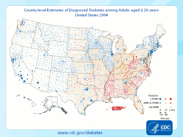
English: An animated map of the United States showing the prevalence of diabetes from 2004-2009.
|
| Date | 12 August 2012 |
| Source | http://www.cdc.gov/obesity/data/adult.html from http://apps.nccd.cdc.gov/DDT_STRS2/NationalDiabetesPrevalenceEstimates.aspx?mode=DBT |
| Author | Centers for Disease Control and Prevention |
Licensing
 |
This image is a work of the Centers for Disease Control and Prevention, part of the United States Department of Health and Human Services, taken or made as part of an employee's official duties. As a work of the U.S. federal government, the image is in the public domain. česky | Deutsch | English | español | eesti | suomi | français | italiano | македонски | Nederlands | polski | português | slovenščina | 中文 | 中文(简体) | +/− |
|
File usage
The following pages on Schools Wikipedia link to this image (list may be incomplete):
Wikipedia for Schools...
SOS Children chose the best bits of Wikipedia to help you learn. SOS Children's Villages believes that a decent childhood is essential to a happy, healthy. Our community work brings families new opportunities through education, healthcare and all manner of support. There are many ways to help with SOS Children's Villages.