

File:Map-Germany-1945.svg
Size of this preview: 565 × 480 pixels.
| |
This is a file from the Wikimedia Commons. Information from its description page there is shown below.
Commons is a freely licensed media file repository. You can help. |
| Description |
العربية: حدود المناطق المحتلة في ألمانيا عام 1957. الاراضي شرق خط نيس تحت السيطرة البولندية والسوفييتية، تظهر بلون ابيض. برلين منطقة مسيطر عليها من عدة بلدان داخل المنطقة السوفييتة.
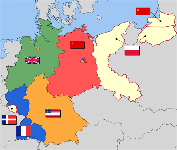
English: Occupation zone borders in Germany, 1947. The territories east of the en:Oder-Neisse line, under Polish and Soviet administration/annexation, are shown as white as is the likewise detached Saar protectorate. Berlin is the multinational area within the Soviet zone.
|
| Date | 2008-03-17 (first version); 2007-08-10 (last version) (Original text : 10 Aug 2007) |
| Source | Transferred from en.wikipedia; transferred to Commons by User:Broadbeer using CommonsHelper. (Original text : Based on map data of the IEG-Maps project (Andreas Kunz, B. Johnen and Joachim Robert Moeschl: University of Mainz) - www.ieg-maps.uni-mainz.de.) |
| Author | en:User:52 Pickup Original uploader was 52 Pickup at en.wikipedia |
| Permission ( Reusing this file) |
CC-BY-SA-2.5. |
Licensing
| This file is licensed under the Creative Commons Attribution-Share Alike 2.5 Generic license. | ||
|
File usage
The following pages on Schools Wikipedia link to this image (list may be incomplete):
Metadata
Schools Wikipedia facts
Wikipedia for Schools is one of SOS Children's many educational projects. SOS Childrens Villages is a global charity founded in 1949 to give children who have lost everything the childhood they deserve. Would you like to sponsor a child?