

File:World 820.png
Size of this preview: 640 × 404 pixels.
| |
This is a file from the Wikimedia Commons. Information from its description page there is shown below.
Commons is a freely licensed media file repository. You can help. |
Summary
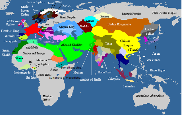
Deutsch: Weltkarte, ca. um 820 n.Chr. Farbige Gebiete zeigen den Einfluss von grösseren Mächten in dieser Zeit, die Kontrolle über manche dieser Gebiete sind z.T. nur nominell vorhanden. Graue Gebiete waren entweder vorwiegend von Ureinwohnern besiedelt oder unbewohnt.
English: Map of the world, c. AD 820. Colored areas show the extent of influence for the major empires of the period; control over some areas may have been purely nominal. Gray areas showed areas that are mainly inhabited by Indigineous populations, or completely uninhabited.
한국어: 서기 820년의 세계지도입니다. 색깔이 있는 지역은 이 시대의 현존했던 왕국과 제국의 영향력을 보여주는 것입니다. 회색지역은 인디언이나 국가가 없던 지역이거나 혹은 사람이 살지 않은 곳입니다.
| Maps of world history | |
| BC |
2000 · 1000 · 500 · 400 · 323 · 300 · 200 · 100 · 50 |
|
|
|
| AD |
1 · 50 · 100 · 200 · 250 · 300 · 400 · 500 · 700 · 750 · 820 · 900 · 1959 · 1980 · |
|
Maps of colonization history |
|
|
see also: Eastern Hemisphere only maps template (1300BC-1500AD) |
|
| (this template: · view · discuss ) | |
 |
This map image could be recreated using vector graphics as an SVG file. This has several advantages; see Commons:Media for cleanup for more information. If an SVG form of this image is already available, please upload it. After uploading an SVG, replace this template with {{ vector version available|new image name.svg}}. |
Licensing
 |
Permission is granted to copy, distribute and/or modify this document under the terms of the GNU Free Documentation License, Version 1.2 or any later version published by the Free Software Foundation; with no Invariant Sections, no Front-Cover Texts, and no Back-Cover Texts. Subject to disclaimers.
|
| This file is licensed under the Creative Commons Attribution-Share Alike 3.0 Unported license. Subject to disclaimers. | ||
|
||
| This licensing tag was added to this file as part of the GFDL licensing update.
|
File usage
The following file is a duplicate of this file ( more details):
The following pages on Schools Wikipedia link to this image (list may be incomplete):
Metadata
I want to learn more...
Wikipedia for Schools is designed to make learning fun and easy. SOS Childrens Villages is a global charity founded in 1949 to give children who have lost everything the childhood they deserve. Try to find out how you can help children in other countries on our web site.