

File:Katrina 2005 track.png
Size of this preview: 640 × 396 pixels.
| |
This is a file from the Wikimedia Commons. Information from its description page there is shown below.
Commons is a freely licensed media file repository. You can help. |
Summary
| Description |
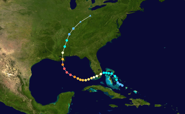
English: Hurricane Katrina track. Uses the colour scheme from the Saffir-Simpson Hurricane Scale. The points show the location of each storm at 6-hour intervals. The colour represents the storm's maximum sustained wind speeds as classified in the Saffir-Simpson Hurricane Scale (see below), and the shape of the data points represent the nature of the storm.
|
|||||||||||||||||||||||||||||||||||||||||||||||||||||||
| Date | August 23–August 30, 2005 | |||||||||||||||||||||||||||||||||||||||||||||||||||||||
| Source | Created using Wikipedia:WikiProject Tropical cyclones/Tracks. The background image was created by NASA. The tracking data is from the National Hurricane Centre's Atlantic hurricane database | |||||||||||||||||||||||||||||||||||||||||||||||||||||||
| Author | Nilfanion | |||||||||||||||||||||||||||||||||||||||||||||||||||||||
Licensing
 |
This work has been released into the public domain by its author, Nilfanion. This applies worldwide. In some countries this may not be legally possible; if so: Nilfanion grants anyone the right to use this work for any purpose, without any conditions, unless such conditions are required by law.
|
File usage
The following pages on Schools Wikipedia link to this image (list may be incomplete):
Find out about Schools Wikipedia
Wikipedia for Schools is one of SOS Childrens Villages' many educational projects. SOS Children is a global charity founded in 1949 to give children who have lost everything the childhood they deserve. We have helped children in Africa for many years - you can help too...