

File:UK Radar1940.JPG
Size of this preview: 402 × 480 pixels.
| |
This is a file from the Wikimedia Commons. Information from its description page there is shown below.
Commons is a freely licensed media file repository. You can help. |
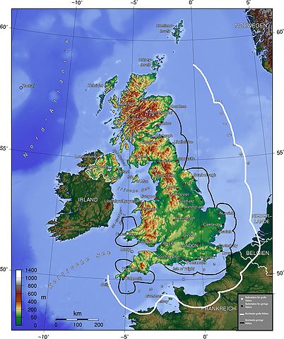
The map (topographic background derived from a German article about Great Britain taken from German wikipedia) gives a quick overview about British radar facilities during the Battle for Britain 1940. I drew the map myself (thats the reason, why it looks quite improvised). Nasiruddin 16:27, 15 August 2005 (UTC)
- Explanation of German legend: White squares indicate high-altitude radar stations, black squares, low-altitude stations. The white line indicates the range of the high-altitude radar, the black line, the range of the low altitude radar.
-
- other versions =


- other versions =
| |
The map has been created with the Generic Mapping Tools: http://gmt.soest.hawaii.edu/ using one or more of these public domain datasets for the relief:
|
 |
Permission is granted to copy, distribute and/or modify this document under the terms of the GNU Free Documentation License, Version 1.2 or any later version published by the Free Software Foundation; with no Invariant Sections, no Front-Cover Texts, and no Back-Cover Texts. A copy of the license is included in the section entitled GNU Free Documentation License.
|
| This file is licensed under the Creative Commons Attribution-Share Alike 3.0 Unported license. | ||
|
||
| This licensing tag was added to this file as part of the GFDL licensing update.
|
File usage
The following pages on Schools Wikipedia link to this image (list may be incomplete):
About Schools Wikipedia
Schools Wikipedia was created by children's charity SOS Childrens Villages. By supporting vulnerable children right through to adulthood, SOS Childrens Villages makes a lasting difference to the lives of thousands of people. Education is a key part of our work, and our schools provide high-quality teaching to the children in our care. There are many ways to help with SOS Children's Villages.