

File:Lake Manly system.png
Lake_Manly_system.png (290 × 315 pixels, file size: 16 KB, MIME type: image/png)
| |
This is a file from the Wikimedia Commons. Information from its description page there is shown below.
Commons is a freely licensed media file repository. You can help. |
| Description |
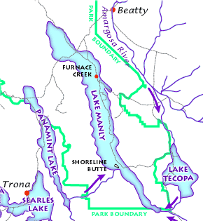
English: The Lake Manly lake system as it might have looked during its last maximum extent 22,000 years ago. (USGS image). The Lake Manly lake system as it might have looked during its last maximum extent 22,000 years ago. Arrows indicate river water flow, gray lines are current highways, and red dots are towns. (USGS image). The Lake Manly lake system as it might have looked during its last maximum extent 22,000 years ago. (USGS image).
Français : Le Lac Manly tel qu'il devait être à son extension maximale, il y a 22 000 années. (Document de l'USGS).
Magyar: A Manly-tó és a környező vízrendszer kb. 22 000 évvel ezelőtt.
Български: Най-вероятно така е изглеждала Долината на смъртта преди 22 000 години.
|
|||
| Date | ||||
| Source | Death Valley Geology Field Trip: Shoreline Butte: |
|||
| Author | ||||
| Permission ( Reusing this file) |
|


File usage
The following pages on Schools Wikipedia link to this image (list may be incomplete):
Wikipedia for Schools...
SOS Children aims to make Wikipedia suitable for young learners. SOS Childrens Villages is there for the children in our care until they are ready for independence. Have you thought about sponsoring a child?