

File:Africa-regions.png

Africa-regions.png (360 × 392 pixels, file size: 8 KB, MIME type: image/png)
| |
This is a file from the Wikimedia Commons. Information from its description page there is shown below.
Commons is a freely licensed media file repository. You can help. |
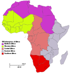
Summary
Africa: subregions as delineated by United Nations geographic classification scheme:
Northern Africa
-
physiographically, country with partial territory in Western Asia – Egypt ( Sinai Peninsula)
Western Africa
Central Africa
Eastern Africa
Southern Africa
Licensing
|

 |
File:Africa map regions.svg is a vector version of this file. It should be used in place of this raster image when superior. File:Africa-regions.png
For more information about vector graphics, read about Commons transition to SVG.
|
 |
File usage
The following pages on Schools Wikipedia link to this image (list may be incomplete):
I want to learn more...
All five editions of Schools Wikipedia were compiled by SOS Children's Villages. Thanks to SOS Children's Villages, 62,000 children are enjoying a happy childhood, with a healthy, prosperous future ahead of them. Have you heard about child sponsorship? Visit our web site to find out.