

File:Trinity Test Fireball 16ms.jpg
| |
This is a file from the Wikimedia Commons. Information from its description page there is shown below.
Commons is a freely licensed media file repository. You can help. |
|
This is an image of a place or building that is listed on the National Register of Historic Places in the United States. Its reference number is 66000493. |
|
||||||
Summary
| Description |
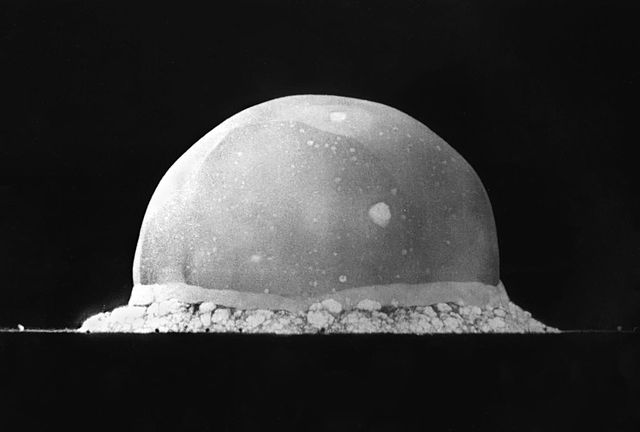
English: PA-98-0520 — Trinity Site explosion, 0.016 second after explosion, July 16, 1945.
Türkçe: 16 Temmuz 1945 yılında New Mexico'daki Socorro'nın 56 km kadar güneydoğusunda şu an üzerinde komuta merkezi Alamogordo'da bulunan White Sands Missile Range'in bulunduğu yerde yapılmış Trinity patlamasının, infilak anından 0,016 sn sonra çekilmiş görüntüsüdür. Görüntülenen yarım kürenin en yüksek noktası yaklaşık 200 metre yüksekliğindedir.
|
|||||
| Date | 16 July 1945 | |||||
| Source | http://www.lanl.gov/orgs/pa/photos/images/PA-98-0520.jpeg | |||||
| Author | Berlyn Brixner | |||||
| Permission ( Reusing this file) |
|
|||||


|
Camera location |
|
This and other images at their locations on: Google Maps - Google Earth - OpenStreetMap | ( Info) |
|---|
File usage
Schools Wikipedia facts
SOS Childrens Villages chose the best bits of Wikipedia to help you learn. SOS Children cares for children who have lost their parents. Our Children's Villages give these children a new home and a new family, while a high-quality education and the best of medical care ensures they will grow up with all they need to succeed in adult life. There are many ways to help with SOS Childrens Villages.