

File:Bermuda topographic map-en.png
| |
This is a file from the Wikimedia Commons. Information from its description page there is shown below.
Commons is a freely licensed media file repository. You can help. |
Summary
|
Camera location |
|
View this and other nearby images on: Google Maps - Google Earth - OpenStreetMap | ( Info) |
|---|
| Description |
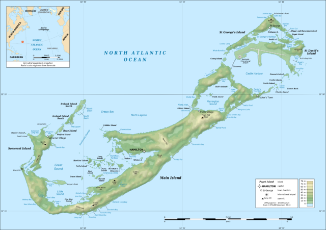
English: Topographic map of Bermuda Islands, Great Britain, in the North Atlantic Ocean.
Note: The background map is a raster image embedded in the SVG file. Français : Carte topographqiue de l' archipel des Bermudes, Grande-Bretagne, dans l'Océan Atlantique Nord.
Note : Le fond de carte est une image bitmap embarquée dans le fichier SVG.
|
||
| Date | April 2009 | ||
| Source | Own work ;
|
||
| Author | Eric Gaba ( Sting - fr:Sting) | ||
| Permission ( Reusing this file) |
|
This map was improved or created by the Wikigraphists of the Graphic Lab (fr). You can propose images to clean up, improve, create or translate as well.
বাংলা | català | česky | Deutsch | Deutsch (Sie-Form) | Ελληνικά | English | Esperanto | español | suomi | français | עברית | magyar | Հայերեն | italiano | 한국어 | македонски | Bahasa Melayu | Plattdüütsch | Nederlands | occitan | polski | português | română | русский | slovenščina | svenska | татарча/tatarça | Türkçe | українська | 中文 | 中文(简体) | 中文(繁體) | Zazaki | +/−
Licensing
|

File usage
A background to Schools Wikipedia
Through Schools Wikipedia, SOS Children has brought learning to children around the world. SOS Children's Villages believes education is an important part of a child's life. That's why we ensure they receive nursery care as well as high-quality primary and secondary education. When they leave school, we support the children in our care as they progress to vocational training or higher education. Help another child by taking out a sponsorship.