

File:Macau-CIA WFB Map.png
Macau-CIA_WFB_Map.png (328 × 352 pixels, file size: 20 KB, MIME type: image/png)
| |
This is a file from the Wikimedia Commons. Information from its description page there is shown below.
Commons is a freely licensed media file repository. You can help. |
See the 2004 version.
Summary
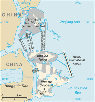
This map represents the Special Administrative Region of Macau of the People's Republic of China, formed by the Peninsula of Macau and the islands of Taipa and Coloane.
Licensing
 |
This image is in the public domain because it contains materials that originally came from the United States Central Intelligence Agency's World Factbook.
|
 |
File usage
The following pages on Schools Wikipedia link to this image (list may be incomplete):
Schools Wikipedia and SOS Children
Schools Wikipedia has been carefully checked to give you the best learning experience. More than 2 million people benefit from the global charity work of SOS Children, and our work in 133 countries around the world is vital to ensuring a better future for vulnerable children. Help another child by taking out a sponsorship.