

File:Mediterranean1400.png
Size of this preview: 640 × 289 pixels.
| |
This is a file from the Wikimedia Commons. Information from its description page there is shown below.
Commons is a freely licensed media file repository. You can help. |
Contents |
Summary
| Description |
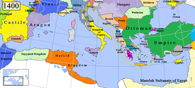
English: Map of the Mediterranean region in AD 1400. (Partially based on Euratlas map of Europe, 1400.)
|
| Date | 29 March 2009 |
| Source | Own work |
| Author | Gabagool |
Licensing
|
![]() The categories of this image should be checked. Check them now!
The categories of this image should be checked. Check them now!
- Remove redundant categories and try to put this image in the most specific category/categories
- Remove this template by clicking here (or on the first line)
File usage on other wikis
Related galleries
File usage
The following pages on Schools Wikipedia link to this image (list may be incomplete):
Find out more
SOS Childrens Villages chose the best bits of Wikipedia to help you learn. SOS Children's Villages cares for children who have lost their parents. Our Children's Villages give these children a new home and a new family, while a high-quality education and the best of medical care ensures they will grow up with all they need to succeed in adult life. If you'd like to help, why not learn how to sponsor a child?