

File:Che Guevara-Granado - Mapa 1er viaje - 1952.jpg
Size of this preview: 341 × 479 pixels.
| |
This is a file from the Wikimedia Commons. Information from its description page there is shown below.
Commons is a freely licensed media file repository. You can help. |
Summary
| Description |
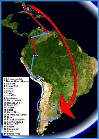
Español: Mapa del primer viaje de Ernesto "Che" Guevara y Alberto Granado, en 1952. Las flechas rojas corresponden a viajes en avión.
English: Map of the first voyage of Ernesto Guevara and Alberto Granado. 1952. Red arrows correspond to travel by airplane.
Français : Parcours du premier périple d'Ernesto "Che" Guevara et d'Alberto Granado, en 1952. Les flèches rouges figurent les déplacements en avion.
|
| Date | 2006 |
| Source | Mapa tomado de World Wind 1.3 (NASA-PD). Itinerario confeccionado por el autor |
| Author | Pepe Robles |
| Permission ( Reusing this file) |
no need PD |
Licensing
 |
I, the copyright holder of this work, release this work into the public domain. This applies worldwide. In some countries this may not be legally possible; if so: I grant anyone the right to use this work for any purpose, without any conditions, unless such conditions are required by law.
|
Scoobidoo bidoo
File usage
The following pages on Schools Wikipedia link to this image (list may be incomplete):
Find out about Schools Wikipedia
All five editions of Schools Wikipedia were compiled by SOS Children's Villages. The world's largest orphan charity, SOS Childrens Villages brings a better life to more than 2 million people in 133 countries around the globe. Why not try to find out more about sponsoring a child?