

File:Lebanon as envisaged by French General Charles-Marie-Napoléon de Beaufort d'Hautpoul Beaufort d'Hautpoul in 1862.jpg
Size of this preview: 364 × 480 pixels.
| |
This is a file from the Wikimedia Commons. Information from its description page there is shown below.
Commons is a freely licensed media file repository. You can help. |
Summary
| Description |
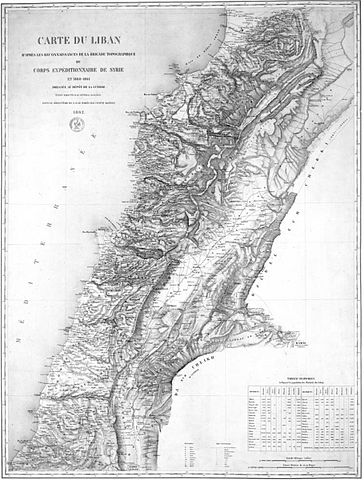
English: Carte du Liban d'apres les reconnaissances de la brigade topographique du corps expeditionnaire de Syrie en 1860-1861 dressee au depot de la guerre.
Lebanon as envisaged by French General Beaufort d'Hautpoul in 1862. This map defined the territory of Greater Lebanon as agreed at the 1919 Paris Peace Conference. |
| Date | 24 March 2013, 18:21:59 |
| Source | Bibliothèque nationale de France |
| Author | Charles-Marie-Napoléon de Beaufort d'Hautpoul |
Licensing
 |
This media file is in the public domain in the United States. This applies to U.S. works where the copyright has expired, often because its first publication occurred prior to January 1, 1923. See this page for further explanation. |
|
|
|
This image might not be in the public domain outside of the United States; this especially applies in the countries and areas that do not apply the rule of the shorter term for US works, such as Canada, Mainland China (not Hong Kong or Macao), Germany, Mexico, and Switzerland. The creator and year of publication are essential information and must be provided. See Wikipedia:Public domain and Wikipedia:Copyrights for more details. |
File usage
The following pages on Schools Wikipedia link to this image (list may be incomplete):
The best way to learn
Wikipedia for Schools was collected by SOS Children's Villages. SOS Children is there for the children in our care until they are ready for independence. Why not try to learn more about child sponsorship?