

File:East-Hem 500ad.jpg
| |
This is a file from the Wikimedia Commons. Information from its description page there is shown below.
Commons is a freely licensed media file repository. You can help. |
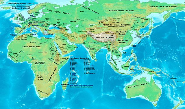
| Description | Eastern Hemisphere in 500 AD. | ||||||
| Date | |||||||
| Source | self-made (For reference information, see the Map Source References section below.) | ||||||
| Author | Thomas Lessman ( Contact!) | ||||||
| Permission ( Reusing this file) |
|
Map Summary
Original Source URL: http://www.thomaslessman.com/History/images/East-Hem_500ad.jpg.
This map of the Eastern Hemisphere in 500 AD was created by Thomas Lessman, based on information from the sources listed below. This map is free for educational use (see Permission info above). When using this map, please mention that it is available for free at www.WorldHistoryMaps.info.
Map Source References
- Remember, sources often conflict with each other. This map is only as accurate as the information that is available to me. To report any errors or to help further this work, please click here, or email Thomas Lessman at talessman@yis.us
References for information contained in this map:
Primary Sources for East-Hem_500ad.jpg:
- 1. The DK Atlas of World History, 2000 Edition; map of The World in 500 CE, (Pages 50-51) (See other specific references below)
- 2. John Nelson's map of the "Countries of the World, 1-1-500 CE", available at www.WorldHistoryMaps.com.
- 3. The History & Commercial Atlas of China, available at Huhai.net
- 4. Wikimedia's World Map 500 CE, made by User:Javierfv1212, and Wikipedia articles (noted below).
I - African Information
Note: Most of my African Information comes from The DK Atlas of World History map of The Development of Complex Societies in Africa; (Pg 160).
- (Bantus, Berber Tribes, Chadians, Cushites, Daamat, Garamantes, Gur, Khoisan Peoples, Kwa, Libyans, Mandes, Nilotic Peoples, West Atlantic Peoples)
- Nubian/Sudanese borders (Makuria, Nobatia, Alodia, Blemmyes, Bega, Axum, etc.) are derived from these sources:
- 1. The DK Atlas of World History map of "Northeast Africa, c. 500 CE"; (Pg. 161)
- 2. Denis Bellemare's Atlas historique de l'Antiquité tardive map of " Arabia in 540 AD"
- Ghana's location is derived from John Nelson's map of the "Countries of the World, 1-1-500 CE", available at www.WorldHistoryMaps.com.
II - Asian Information
- Arabian borders & Tribal locations are derived from a combination of these sources:
- 1. The MidEastWeb.org map of Arabia in 500 CE.
- 2. Denis Bellemare's Atlas historique de l'Antiquité tardive map of " Arabia in 540 AD"
Note: A very different set of information for Arabia is shown in each of those maps, even taking the 40-year difference between them. I used information in various Wikipedia articles about subject tribes and states to reconcile the maps and the borders I depict in this map.
- Chinese borders are derived from the History & Commercial Atlas of China, map of S Ch'i & N Wei Dynasties in 500 A.D. (南齐和北魏-公元500年的边界), available on Huhai.net.
- Hephthalite borders are derived from a mix of:
- 1. Northern borders are from the History & Commercial Atlas of China, map of S Ch'i & N Wei Dynasties in 500 A.D. (南齐和北魏-公元500年的边界), available on Huhai.net.
- 2. Eastern borders are derived from John Nelson's map of the "Countries of the World, 1-1-500 CE", available at www.WorldHistoryMaps.com.
- India's borders are derived from these sources:
- 1. John Nelson's map of the "Countries of the World, 1-1-500 CE", available at www.WorldHistoryMaps.com.
- 2. The Historical Atlas of South Asia, maps of " The Gupta-Vakataka Age, c. A.D. 300-500" and " The age of Pusyabhuti and Calukyan ascendancy, c. A.D. 550-700", by Joseph Schwartzberg.
- Japan information is derived from The DK Atlas of World History map of "State Formation in Korea & Japan to 650 CE"; (Pg 264)
- Korean borders are derived from the History_of_Korea-476 map, created by User:Historiographer.
- Rouran/Juan-Juan borders are derived primarily from the History & Commercial Atlas of China; map of Southern Ch'i & Northern Wei Dynasties-Boundaries of 500 A.D.; available on Huhai.net.
- Sassanid Persian borders are derived from these sources:
- 1. Eastern borders are derived from John Nelson's map of the "Countries of the World, 1-1-500 CE", available at www.WorldHistoryMaps.com.
- 2. Western and northern borders are from the Euratlas.com map of Europe in 500 AD
- Southeast Asia information is from:
- 1. The Historical Atlas of South Asia, maps of " Southeast Asia to 650 AD."
- 2. The DK Atlas of World History map of "Southeast Asia to 650 CE", (Pg 241) and map of "The World in 500", (Pg 50).
III - European Information
Note: My primary source of information for Europe is the Euratlas.com map of Europe in 500 AD
- Britain and Ireland borders are derived from these sources (which I highly recommend you examine for a better view than my wide-scale map can depict):
- 1. The EarlyBritishKingdoms.com map of Britain in 500 AD
- 2. User:Briangotts' map of Britain 500 CE.
Note: Much of the information in this map was cross-checked with Regnal Chronologies by Bruce Gordon.
Other Maps by Thomas Lessman
File usage
What is Schools Wikipedia?
Wikipedia for Schools is one of SOS Children's Villages' many educational projects. SOS Children's Villages works in 133 countries and territories across the globe, helps more than 62,000 children, and reaches over 2 million people in total. Why not try to learn more about child sponsorship?