

File:Cretaceous seaway.png
| |
This is a file from the Wikimedia Commons. Information from its description page there is shown below.
Commons is a freely licensed media file repository. You can help. |
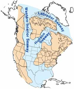
Map of North America highlighting the shallow inland seaways present during the mid- Cretaceous period. By William A. Cobban and Kevin C. McKinney, USGS. (Image has been slightly modified by uploader to remove "CO" state designation.)
 |
This image is in the public domain because it contains materials that originally came from the United States Geological Survey, an agency of the United States Department of the Interior. For more information, see the official USGS copyright policy. български | català | Deutsch | English | español | eesti | suomi | français | galego | italiano | 한국어 | македонски | മലയാളം | Nederlands | polski | português | русский | Türkçe | 中文 | 中文(简体) | +/− |
|
File usage
More information
SOS Childrens Villages has brought Wikipedia to the classroom. More than 2 million people benefit from the global charity work of SOS Children, and our work in 133 countries around the world is vital to ensuring a better future for vulnerable children. There are many ways to help with SOS Childrens Villages.