

File:Apdx F2 - Aerial photo after explosion.jpg
Summary
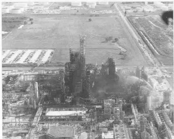
Aerial photo of complex as seen from north to south. Dark arrow at top points to the north edge of the staging area for responding mutual aid equipment. Area of origin thought to be near centre (light arrow).
Appendix F1. Aerial photo of complex as seen from north to south, from page 89 of http://ncsp.tamu.edu/reports/USFA/pasadena.pdf . This is a document is under the auspices of the United States Fire Administration, Technical Report Series, entitled "Phillips Petroleum Chemical Plant Explosion and Fire -- Pasadena, Texas" from the Federal Emergency Management Agency, United States Fire Administration, National Fire Data Centre.
Licensing
 |
This image is a work of a Federal Emergency Management Agency employee, taken or made as part of that person's official duties. As a work of the U.S. federal government, the image is in the public domain. | |
 |
This is a candidate to be copied to Wikimedia Commons. Freely licensed or public domain media are more accessible to other Wikimedia projects if placed on Commons. Any user may perform this move—please see Moving images to the Commons for more information. Please thoroughly review the copyright status of this file and ensure that it is actually eligible for transfer to Commons. If you are concerned that this file could have problems with its attribution information and/or copyright status, then remove this notice and DO NOT transfer it to Commons. By transferring this file to Commons, you acknowledge you have read this message and are willing to accept any and all consequences for inappropriate transfers. Repeat violators will be blocked from editing. If you have checked the file and it is OK to move to Commons add "|human=username" to the template so other users can see it has been checked and can help you copy the file to Commons. If the file can't be moved to Commons consider nominating the file for deletion or changing the template to {{NotMovedToCommons|reason=Why it can't be copied to Commons}} If this image has been copied to Commons replace this tag with {{subst:ncd}} or {{subst:ncd|Image name on Commons.ext}} if a different filename is used on Commons. Copy to Commons: via CommonsHelper |
||
|
|||
File usage
Learn more
Wikipedia for Schools is one of SOS Children's Villages' many educational projects. Thanks to SOS Children's Villages, 62,000 children are enjoying a happy childhood, with a healthy, prosperous future ahead of them. Would you like to sponsor a child?