

File:SafsafOasis SAR comparison.jpg
Size of this preview: 440 × 479 pixels.
| |
This is a file from the Wikimedia Commons. Information from its description page there is shown below.
Commons is a freely licensed media file repository. You can help. |
Summary
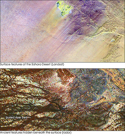
| Description | Two images of the Safsaf Oasis in The Sahara. The top image (taken by the Landat Thematic Mapper) is the surface. The bottom (taken by the Spaceborne Imaging Radar-C/X-band Synthetic Aperture Radar (SIR-C/X-SAR) on board the Space Shuttle Endeavour on April 16, 1994) is the rock layer underneath, revealing black channels cut by the meandering of an ancient river. |
| Date | not specified |
| Source | http://earthobservatory.nasa.gov/Newsroom/NewImages/images.php3?img_id=16963 |
| Author | NASA/JPL Imaging Radar team. |
| Permission ( Reusing this file) |
Public domain |
Licensing
 |
This file is in the public domain because it was solely created by NASA. NASA copyright policy states that "NASA material is not protected by copyright unless noted". (See Template:PD-USGov, NASA copyright policy page or JPL Image Use Policy.) |
 |
 |
Warnings:
|
File usage
The following pages on Schools Wikipedia link to this image (list may be incomplete):
Find out more
Schools Wikipedia was launched to make learning available to everyone. SOS Children helps those who have nothing and no one, giving them back the famly they have lost and bringing them the very best opportunities for a happy, healthy future. Try to find out how you can help children in other countries on our web site.