

File:Fallout map USA (FEMA).jpg
| |
This is a file from the Wikimedia Commons. Information from its description page there is shown below.
Commons is a freely licensed media file repository. You can help. |
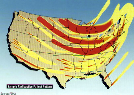
Map of nuclear fallout distribution after a potential nuclear attack on the United States. Looks to be mapping length of fallout after a day or two based on common weather trajectories.
- Source: Risks and Hazards: A State By State Guide FEMA-196 (September 1990). FEMA publication.
Image credited to FEMA. Originally based on image from http://www.ki4u.com/nuclearsurvival/list.htm, cleaned up a bit. Uploaded by en:User:Fastfission.
 |
This work is in the public domain in the United States because it is a work prepared by an officer or employee of the United States Government as part of that person’s official duties under the terms of Title 17, Chapter 1, Section 105 of the US Code. See Copyright. Note: This only applies to original works of the Federal Government and not to the work of any individual U.S. state, territory, commonwealth, county, municipality, or any other subdivision. This template also does not apply to postage stamp designs published by the United States Postal Service since 1978. (See 206.02(b) of Compendium II: Copyright Office Practices). It also does not apply to certain US coins; see The US Mint Terms of Use. |
 |
|
|
||
(originally uploaded to en)
File usage
Did you know...?
Wikipedia for Schools was collected by SOS Childrens Villages. SOS Children cares for children who have lost their parents. Our Children's Villages give these children a new home and a new family, while a high-quality education and the best of medical care ensures they will grow up with all they need to succeed in adult life. There are many ways to help with SOS Children's Villages.