

File:Kiribati-Caroline-highlighted.PNG
Kiribati-Caroline-highlighted.PNG (300 × 322 pixels, file size: 57 KB, MIME type: image/png)
| |
This is a file from the Wikimedia Commons. Information from its description page there is shown below.
Commons is a freely licensed media file repository. You can help. |
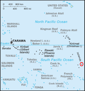
Summary
| Description | Adapted version of the post-1995 South Pacific section of en::Image:Kr-map.png, with en:Caroline Island highlighted. |
| Date | 2006-06-14 (original upload date) |
| Source | https://www.cia.gov/cia/publications/factbook/geos/kr.html |
| Author | own work, based on original |
Licensing
 |
This image is in the public domain because it contains materials that originally came from the United States Central Intelligence Agency's World Factbook.
|
 |
File usage
The following pages on Schools Wikipedia link to this image (list may be incomplete):
More information
All five editions of Schools Wikipedia were compiled by SOS Children. More than 2 million people benefit from the global charity work of SOS Children, and our work in 133 countries around the world is vital to ensuring a better future for vulnerable children. Why not try to find out more about sponsoring a child?