

File:India Goa locator map.svg
| |
This is a file from the Wikimedia Commons. Information from its description page there is shown below.
Commons is a freely licensed media file repository. You can help. |
| WikiProject India Maps |
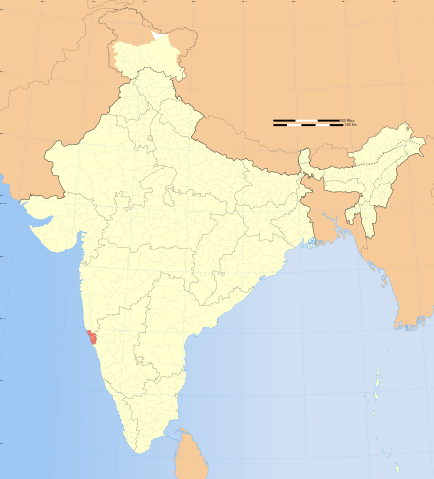
Goa locator map |
||||||
|---|---|---|---|---|---|---|---|
| Description |
Locator map of the state of Goa, India with district boundaries. |
||||||
| Source |
International Borders: University of Texas map library - India Political map 2001 |
||||||
| Date |
2008-12-29 |
||||||
| Author |
|
||||||
| Other versions | |||||||
| License |
|
Contents |
Legend

Depiction of India's Borders
- The territorial boundaries of India are shown as per the actual ground situation in accordance with international practices followed by the United Nations and the National Geographic Society
- This map is meant to be for illustrative purpose only and is not authenticated by official government sources. Please check the list of sources and references used to create the map for a measure of accuracy and verifiability.
- The usage of these maps in India, Pakistan and China are governed by different laws that restrict depictions of boundaries other than what is officially recognized by the state. Please check local laws and modify the map accordingly before use
Explanation of disputed boundaries
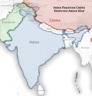
- Boundary of Indian claim : The territory India claims is legally theirs, but the claim is disputed by China and Pakistan.
- Line of Control/Line of Conflict : The defacto administrative boundary recognised by the international community. This UN ceasefire Line is considered as a temporary solution to an ongoing conflict since the departure of the British Raj.
Borders of disputed regions
The extent of the former territory of the British Indian Empire, seceeded by Republic of India depicted on this map may not be accepted by most countries as legal due to ongoing border disputes:
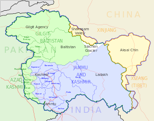
- The northern Himalayan region of the disputed territory w:Indian-administered Kashmir is claimed by India including ( Pakistan-administered Kashmir) and the Chinese Occupied territory of ( Ladakh plateau). It is currently divided between all three countries since 1972. See also Line of Control and Line of Actual Control.
- The north eastern territory of Arunachal Pradesh is almost entirely claimed by China as part of its Tibetan territory.
- Minor areas of eastern Kashmir's Ladakh division, Himachal Pradesh and Uttarakhand on the Chinese frontier are claimed by China. These areas are under Indian control.
- A small area of Uttarakhand adjoining the Nepal border along the Sarda river is disputed between the two countries.
For a detailed map of all disputed regions in South Asia, see Image:India disputed areas map.svg
Internal borders
The borders of the state of Meghalaya, Assam and Arunachal Pradesh is shown as interpreted from the North-Eastern Areas (Reorganisation) Act, 1971, but has yet to be verified.
Territorial Waters
The limit of the territorial waters of India extends to twelve nautical miles measured from the appropriate baseline. See this for more information.
Errata
If you notice a mistake on the map, list them here. Please mention the name of the map to be corrected also.
- This is not the updated map of 2002. It is the one that was prepared by Indian Standard Code:1893 in 1970. In the new map there is no Zone I at all.
- Pondicherry is now Puducherry
- The capital of the Union Territory of Daman and Diu is at Daman and not Diu.
- The capital of Assam is Dispur and not Guwahati
The Romanization/pinyin of Tibet is not Xijang, it is Xizang.(fixed)- National Highway 1C should be National Highway 1B. Please check here en:National Highway 1 (India). You will find the highway at 72 Deg N / 32 Deg W near Jammu City in the state of Jammu and Kashmir. National Highway 1B starts just above Jammu City and goes towards Vaishno Devi. Please refer here for help.
- Missing new districts (I believe 8 in Indian-administered J&K, 2 in AJK and a quite different division of Gilgit-Baltistan).
- Image:India population density map en.svg: There is an error saying the SVG source is invalid.
- The symbols used are large, making it hard to see the population density near capital cities.
- Is the large red patch in the Lakshadweep Islands intentional?
- Two New Districts named Mewat and Palwal in Haryana are missing.
- India roadway map.svg: The capital of Mizoram is spelt incorrectly.
- Why only 14 districts are shown in Jammu & Kashmir map instead of 22?
- In File:Assam locator map.svg the new 3 districts are not included.
File usage
Metadata
Schools Wikipedia and SOS Children
SOS Childrens Villages aims to make Wikipedia suitable for young learners. SOS Childrens Villages helps more than 2 million people across 133 countries around the world. There are many ways to help with SOS Childrens Villages.