

File:ClimateMajuroMarshallIslands.PNG
ClimateMajuroMarshallIslands.PNG (450 × 450 pixels, file size: 3 KB, MIME type: image/png)
| |
This is a file from the Wikimedia Commons. Information from its description page there is shown below.
Commons is a freely licensed media file repository. You can help. |
 |
This graph image could be recreated using vector graphics as an SVG file. This has several advantages; see Commons:Media for cleanup for more information. If an SVG form of this image is already available, please upload it. After uploading an SVG, replace this template with {{ vector version available|new image name.svg}}. |
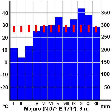
Climate diagram of Majuro, Marshall Islands
max. and min. temperature and total precipitations per month
drawn by Miaow Miaow, April 2005
 |
I, the copyright holder of this work, release this work into the public domain. This applies worldwide. In some countries this may not be legally possible; if so: I grant anyone the right to use this work for any purpose, without any conditions, unless such conditions are required by law.
|
File usage
The following pages on Schools Wikipedia link to this image (list may be incomplete):
Learn more
Wikipedia for Schools is one of SOS Childrens Villages' many educational projects. SOS Childrens Villages believes that a decent childhood is essential to a happy, healthy. Our community work brings families new opportunities through education, healthcare and all manner of support. There are many ways to help with SOS Children.