

File:Cg-map.png

Cg-map.png (330 × 354 pixels, file size: 55 KB, MIME type: image/png)
| |
This is a file from the Wikimedia Commons. Information from its description page there is shown below.
Commons is a freely licensed media file repository. You can help. |
Summary
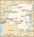
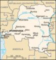
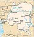
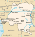
| Description | Democratic Republic of the Congo map from CIA World Factbook, converted from original GIF format (July 2011 version showing South Sudan)
|
| Date | 13 July 2011 |
| Source | CIA World Factbook
|
| Author | United States Central Intelligence Agency |
Licensing
 |
This image is in the public domain because it contains materials that originally came from the United States Central Intelligence Agency's World Factbook.
|
 |
Derivative works
Derivatives of 2011 map (showing South Sudan):
-
Congo CIA map PL.png
polski
Derivatives of 2002 map:
-
Congo Rep Dem carte.gif
français -
DRK kaart.png
Afrikaans -
Karte der Demokratischen Republik Kongo.png
Deutsch -

Mapa dem rep Kongo.png
česky
File usage
The following pages on Schools Wikipedia link to this image (list may be incomplete):
Did you know...?
Through Schools Wikipedia, SOS Children's Villages has brought learning to children around the world. By supporting vulnerable children right through to adulthood, SOS Children makes a lasting difference to the lives of thousands of people. Education is a key part of our work, and our schools provide high-quality teaching to the children in our care. Try to find out how you can help children in other countries on our web site.