

File:Southern Ocean.png
Southern_Ocean.png (330 × 330 pixels, file size: 10 KB, MIME type: image/png)
| |
This is a file from the Wikimedia Commons. Information from its description page there is shown below.
Commons is a freely licensed media file repository. You can help. |
Summary
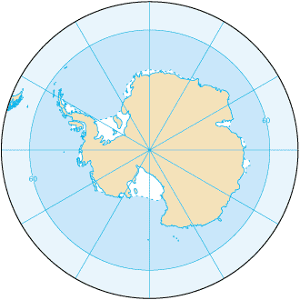
Southern_Ocean (from en:) Map from CIA Factbook 2003: Southern Ocean (picture link is ).
English version: File:Southern Ocean - en.png Slovene version: File:Southern Ocean-sl.png
Licensing
 |
This image is in the public domain because it contains materials that originally came from the United States Central Intelligence Agency's World Factbook.
|
 |
 |
This map image could be recreated using vector graphics as an SVG file. This has several advantages; see Commons:Media for cleanup for more information. If an SVG form of this image is already available, please upload it. After uploading an SVG, replace this template with {{ vector version available|new image name.svg}}. |
File usage
The following pages on Schools Wikipedia link to this image (list may be incomplete):
Schools Wikipedia and SOS Children
All five editions of Schools Wikipedia were compiled by SOS Children. Thanks to SOS Children, 62,000 children are enjoying a happy childhood, with a healthy, prosperous future ahead of them. If you'd like to help, why not learn how to sponsor a child?