

File:LocationRhodesia.png
LocationRhodesia.png (250 × 115 pixels, file size: 5 KB, MIME type: image/png)
| |
This is a file from the Wikimedia Commons. Information from its description page there is shown below.
Commons is a freely licensed media file repository. You can help. |
 |
This map image could be recreated using vector graphics as an SVG file. This has several advantages; see Commons:Media for cleanup for more information. If an SVG form of this image is already available, please upload it. After uploading an SVG, replace this template with {{ vector version available|new image name.svg}}. |
Summary
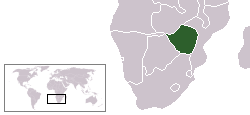
| Description | English: Locator map for South Rhodesia (now Zimbabwe). It shows Walvis Bay (Namibia) as part of South Africa (during the brief time Rhodesia existed, South Africa held Walvis Bay). | ||
| Date | 13 December 2005 | ||
| Source | Own work | ||
| Author | User:*drew | ||
| Permission ( Reusing this file) |
|

File usage
The following pages on Schools Wikipedia link to this image (list may be incomplete):
A background to Schools Wikipedia
Through Schools Wikipedia, SOS Childrens Villages has brought learning to children around the world. SOS Childrens Villages helps more than 2 million people across 133 countries around the world. Try to find out how you can help children in other countries on our web site.