

File:Osetia Południowa.png
Size of this preview: 521 × 479 pixels.
| |
This is a file from the Wikimedia Commons. Information from its description page there is shown below.
Commons is a freely licensed media file repository. You can help. |
Summary
| Description |
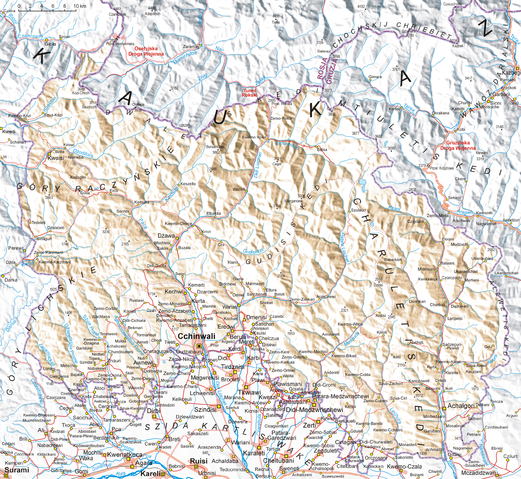
English: Map of South Ossetia, based on Soviet topographic map published in the eighties and Shuttle Radar Topography Mission (STRM). Names are in Polish transcription based on rules of Commission on Standardization of Geographical Names Outside the Republic of Poland. Differences between Polish transcription and English one: C=TS, CH=KH, CZ=CH, DŻ=J, J=Y, Ł=W, SZ=SH, W=V (i.e.: CCHINWALI=TSKHINVALI, MCZADIDŻWARI=MCHADIJVARI, SZUA-CIRI=SHUA-TSIRI etc.)
Polski: Mapa Osetii Południowej. Mapa opracowana na podstawie radzieckich map topograficznych w skali 1:100 000 z końca lat 80., rzeźba terenu wygenerowana na podstawie danych Shuttle Radar Topography Mission (STRM) udostępnionych przez United States Geological Survey. Nazewnictwo gruzińskie i rosyjskie podane zostało w polskiej transkrypcji fonetycznej zgodnie z tabelami latynizacyjnymi Komisji Standaryzacji Nazw Geograficznych, a polskie egzonimy wg wkazów tejże Komisji.
Legenda: 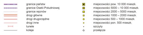 |
| Date | 16 August 2008 |
| Source | Own work |
| Author | Aotearoa |
Licensing
|

File usage
The following pages on Schools Wikipedia link to this image (list may be incomplete):
Learn more
SOS Children chose the best bits of Wikipedia to help you learn. Thanks to SOS Children's Villages, 62,000 children are enjoying a happy childhood, with a healthy, prosperous future ahead of them. There are many ways to help with SOS Children's Villages.