|
This is a file from the Wikimedia Commons. Information from its description page there is shown below.
Commons is a freely licensed media file repository. You can help.
|
| Description |
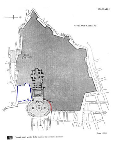
VaticanCity Annex.jpg
Deutsch: Karte der Vatikanstadt (aus dem Annex der Lateranverträge)
- dunkelgrau: Territorium der Vatikanstadt
- hellgrau (Petersplatz): Territorium der Vatikanstadt; Sicherheitsagenden an italienische Sicherheitskräfte delegiert (jederzeit widerrufbar).
- rot: Der schmale Streifen (ca. 3 m breit und 60 m lang) entlang der Außenseite der rechten (d. h. nördlichen) Kolonnade Berninis ist nach den Lateranverträgen italienisches Territorium und unterliegt der italienischen Jurisdiktion. Diese Tatsache wurde von einer gemischten vatikanisch-italienischen Kommission, die bis 1932 tagte und welche die technischen Details der Verträge präzisierte, bestritten. Da diese Kommission jedoch von italienischen Seite nicht mit hochrangigen Juristen beschickt wurde und darüber hinaus nur beratende Funktion innehatte, wird die rechtliche Relevanz dieses Standpunktes von Italien nicht anerkannt.
- blau umrandet: Das blauumrandete Gebiet ist zwar italienisches Territorium, steht jedoch im Besitz des Heiligen Stuhls und genießt exterritorialen Status (vergleichbar mit ausländischen Botschaften). Es untersteht nicht der italienischen Jurisdiktion.
- Sonstiges: Das hellgraue Areal südlich des vatikanischen Bahnhofs (stazione) wurde laut Notiz links unten auf der Karte als "Fläche auf italienischem Territorium zur Versorgung des Bahnhofs" eingefärbt (dieser Bereich wurde in einer Karte der Gazetta Ufficiale von 1929 nicht hellgrau unterlegt). Möglicherweise wurde es dem Heiligen Stuhl aus dem genannten Grund als exterritoriale Besitzung auf italienischem Boden (eine Quelle weist es als solches aus) zur Verfügung gestellt.
English: Boundary map taken from the annex of the Lateran treaties. Colored areas are modifications of original image for purposes of clarification.
- dark grey: territory of Vatican City.
- light grey: territory of Vatican City. Security dispositive of Italy. Free access to public and to Italian police authorities may be revoked at any time for special ceremonial occasions.
- red: The small strip (3 m wide, 60 m long) alongside the northern colonnade is - according to the Lateran treaties - Italian territory and underlies Italian jurisdiction. This fact has been disputed by the mixed Italian-Vatican commission which was in place until 1932 to refine and detail the findings of the treaties. Since this commission had only a consultatory status Italy does not recognize any legal relevance of this dispute.
- blue zone: territory of Italy, but in possession of the Holy See. The area has extraterritorial status and Italian jurisdiction is not applied. The area contains the seat of the en:Congregation for the Doctrine of the Faith, the bigger part of the en:Paul VI Audience Hall, the Campo Santo Teutonico and the German College.
- other: The light grey area next to the station has evidently been added in by mistake and is Italian territory.
Română: * gri închis: teritoriu al Vaticanului.
- gri deschis: teritoriu al Vaticanului. Dispozitivele de securitate ale Italiei. Accesul liber pentru public și pentru poliția italiană poate fi suspendat oricând pentru ocazii ceremoniale speciale.
- roșu: O mică fâșie (lată de 3m, lungă de 60m) de-alungul coloanelor nordice este - în conformitate cu tratatul - teritoriu Italian sub jurisdicție italianp. Faptul a fost disputat de comisii mixte italiene-vaticane până în 1932 pentru detalierea tratatelor. Deoarece comisia a avut doar statut consultativ Italia nu recunoaște din punct de vedere legal această dispută.
- zona albastră: teritoriu italian, dar în posesia Sfântulu Scaun. Zona are statut extrateritorial și nu se aplică jurisdicția italiană. Zona conține biroul Congregației pentru doctrina credinței, partea cea mare a sălii de audiențe Paul VI, Campo Santo Teutonico și colegiul german.
- altele: Zona gri deschis de lângă stația feroviară a fost adăugată probabil din greșeală și este teritoriu italian.
|
| Date |
11 February 1929 |
| Source |
Annex of the Lateran Treaty |
| Author |
Original: de:Bild:Vatikanstadt_Annex.jpg, amended by gugganij |
| Public domainPublic domainfalsefalse |
 |
This map has been uploaded by Electionworld from en.wikipedia.org to enable the  Wikimedia Atlas of the World Wikimedia Atlas of the World  . Original uploader to en.wikipedia.org was El Suizo, known as El Suizo at en.wikipedia.org. Electionworld is not the creator of this map. Licensing information is below. . Original uploader to en.wikipedia.org was El Suizo, known as El Suizo at en.wikipedia.org. Electionworld is not the creator of this map. Licensing information is below. |
Licensing
| Public domainPublic domainfalsefalse |
 |
This image (or other media file) is in the public domain because its copyright has expired.
This applies to Australia, the European Union and those countries with a copyright term of life of the author plus 70 years.
 You must also include a United States public domain tag to indicate why this work is in the public domain in the United States. Note that a few countries have copyright terms longer than 70 years: Mexico has 100 years, Colombia has 80 years, and Guatemala and Samoa have 75 years, Russia has 74 years for some authors. This image may not be in the public domain in these countries, which moreover do not implement the rule of the shorter term. Côte d'Ivoire has a general copyright term of 99 years and Honduras has 75 years, but they do implement the rule of the shorter term. You must also include a United States public domain tag to indicate why this work is in the public domain in the United States. Note that a few countries have copyright terms longer than 70 years: Mexico has 100 years, Colombia has 80 years, and Guatemala and Samoa have 75 years, Russia has 74 years for some authors. This image may not be in the public domain in these countries, which moreover do not implement the rule of the shorter term. Côte d'Ivoire has a general copyright term of 99 years and Honduras has 75 years, but they do implement the rule of the shorter term.
|
|
This file has been identified as being free of known restrictions under copyright law, including all related and neighboring rights.
|
File usage
The following pages on Schools Wikipedia link to this image (list may be incomplete):
SOS Children's Villages has brought Wikipedia to the classroom. By supporting vulnerable children right through to adulthood, SOS Children's Villages makes a lasting difference to the lives of thousands of people. Education is a key part of our work, and our schools provide high-quality teaching to the children in our care. Sponsoring a child is a great way to help children who need your support.