Checked content

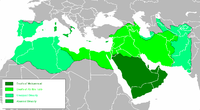
File:Shattering isochamend.png

Summary

Description Isochronic map of Caliphate fragmentation
Date
Source self-made derived from
Arabempire isoch.png

http://www.maproom.org/00/46/present.php?m=0082

Plate 82 from Hand-Atlas für die Geschichte des Mittelalters und die neueren Zeit by Spruner and Menke Index no. 0046:0082 The lands of Islam to the time of the Buyids, 945-1055. Southern Arabia. (Western continuation of the main map.) The Ghaznavid Empire about 1002/3. The Eastern Roman Empire about 1002/3. — Die Länder des Islâm zur Zeit der Bûjiden 945-1055. Südliches Arabien.

Reich der Ghazneviden um 1002/3.

Oströmisches Reich 1021 bis 1055

http://www.maproom.org/00/08/present.php?m=0077

Plate 77 from Professor G. Droysens Allgemeiner Historischer Handatlas by R. Andree Index no. 0008:0077

The Caliphate, to 945 — Reich der Kalifen bis 945
Author Busterof666

Licensing

Public domain I, the copyright holder of this work, release this work into the public domain. This applies worldwide.
In some countries this may not be legally possible; if so:
I grant anyone the right to use this work for any purpose, without any conditions, unless such conditions are required by law.

Annotations This image is annotated: View the annotations at Commons
The following pages on Schools Wikipedia link to this image (list may be incomplete):

Find out about Schools Wikipedia

SOS Children's Villages chose the best bits of Wikipedia to help you learn. More than 2 million people benefit from the global charity work of SOS Children, and our work in 133 countries around the world is vital to ensuring a better future for vulnerable children. Help another child by taking out a sponsorship.