

Burkina Faso
Did you know...
SOS Children has tried to make Wikipedia content more accessible by this schools selection. SOS Children works in 45 African countries; can you help a child in Africa?
|
Burkina Faso
|
||||||
|---|---|---|---|---|---|---|
|
||||||
| Motto: "Unité–Progrès–Justice" (French) "Unity–Progress–Justice" |
||||||
| Anthem: Une Seule Nuit / Ditanyè (French) One Single Night / Hymn of Victory |
||||||
![Location of Burkina Faso (dark blue)– in Africa (light blue & dark grey)– in the African Union (light blue) — [Legend]](../../images/1667/166796.png.htm) Location of Burkina Faso (dark blue)
– in Africa (light blue & dark grey) |
||||||
| Capital and largest city |
Ouagadougou 12°20′N 1°40′W |
|||||
| Official languages | French | |||||
| Recognised regional languages |
|
|||||
| Ethnic groups (1995) |
|
|||||
| Demonym |
|
|||||
| Government | Semi-presidential republic | |||||
| - | President | Blaise Compaoré | ||||
| - | Prime Minister | Luc-Adolphe Tiao | ||||
| Legislature | National Assembly | |||||
| Independence | ||||||
| - | from France | 5 August 1960 | ||||
| Area | ||||||
| - | Total | 274,200 km2 ( 74th) 105,869 sq mi |
||||
| - | Water (%) | 0.146% | ||||
| Population | ||||||
| - | 2010 estimate | 15,730,977 ( 64th) | ||||
| - | 2006 census | 14,017,262 | ||||
| - | Density | 57.4/km2 ( 145th) 148.9/sq mi |
||||
| GDP ( PPP) | 2011 estimate | |||||
| - | Total | $22.042 billion | ||||
| - | Per capita | $1,466 | ||||
| GDP (nominal) | 2011 estimate | |||||
| - | Total | $9.981 billion | ||||
| - | Per capita | $664 | ||||
| Gini (2007) | 39.5 medium |
|||||
| HDI (2007) | low · 177th |
|||||
| Currency | West African CFA franc ( XOF) |
|||||
| Time zone | ( UTC+0) | |||||
| - | Summer ( DST) | not observed ( UTC) | ||||
| Drives on the | right | |||||
| Calling code | +226 | |||||
| ISO 3166 code | BF | |||||
| Internet TLD | .bf | |||||
| The data here is an estimation for the year 2005 produced by the International Monetary Fund in April 2005. | ||||||


Burkina Faso ( / b ər ˌ k iː n ə ˈ f ɑː s oʊ / bər-KEE-nə FAH-soh; French: [buʁkina faso]), also known by its short-form name Burkina, is a landlocked country in west Africa around 274,200 square kilometres (105,900 sq mi) in size. It is surrounded by six countries: Mali to the north; Niger to the east; Benin to the southeast; Togo and Ghana to the south; and Ivory Coast to the southwest. Its capital is Ouagadougou. In 2010, its population was estimated at just under 15.75 million.
Formerly called the Republic of Upper Volta, the country was renamed "Burkina Faso" on 4 August 1984 by then-President Thomas Sankara, using a word from each of the country's two major native languages, Mòoré and Dioula. Figuratively, "Burkina", from Mòoré, may be translated as "men of integrity", while "Faso" means "fatherland" in Dioula. "Burkino Faso" is thus meant to be understood as "Land of upright people" or "Land of honest people". Inhabitants of Burkina Faso are known as Burkinabè (pron.: / b ər ˈ k iː n ə b eɪ / bər-KEE-nə-bay).
Between 14,000 and 5000 BC, Burkina Faso was populated by hunter-gatherers in the country's northwestern region. Farm settlements appeared between 3600 and 2600 BC. What is now central Burkina Faso was principally composed of Mossi kingdoms. These Mossi Kingdoms became a French protectorate in 1896. After gaining independence from France in 1960, the country underwent many governmental changes until arriving at its current form, a semi-presidential republic. The president is Blaise Compaoré.
Burkina Faso is a member of the African Union, Community of Sahel-Saharan States, La Francophonie, Organisation of Islamic Cooperation and Economic Community of West African States.
History
Early history
The territory of today's Burkina Faso was populated between 14,000 and 5000 BC, by hunter-gatherers in the northwestern part of the country, whose tools, such as scrapers, chisels and arrowheads, were discovered in 1973 by Simran Nijjar. Settlements with farmers appeared between 3600 and 2600 BC. On the basis of traces of the farmers' structures, the settlements appear to have been permanent. The use of iron, ceramics and polished stone developed between 1500 and 1000 BC, as did a preoccupation with spiritual matters, as shown by burial remains.
Relics of the Dogon are found in Burkina Faso's north and northwest regions. Sometime between the fifteenth and sixteenth centuries, the Dogon left the area to settle in the cliffs of Bandiagara. Elsewhere, the remains of high walls are localized in the southwest of Burkina Faso (as well as in the Côte d'Ivoire), but the people who built them have not yet been identified. Loropeni is a pre-European stone ruin which was linked to the gold trade. It has been declared as Burkina Faso's first World Heritage site.
The central part of Burkina Faso included a number of Mossi kingdoms, the most powerful of which were those of Wagadogo (Ouagadougou) and Yatenga. These kingdoms emerged probably in the early sixteenth century from obscure origins veiled by legend featuring a heterogeneous set of warrior figures.
From colony to independence


After a decade of intense rivalry and competition between the British and the French, waged through treaty-making expeditions under military or civilian explorers, the Mossi kingdom of Ouagadougou was defeated by French colonial forces and became a French protectorate in 1896. The eastern region and the western region, where a standoff against the forces of the powerful ruler Samori Ture complicated the situation, came under French occupation in 1897. By 1898, the majority of the territory corresponding to Burkina Faso today was nominally conquered; however, control of many parts remained uncertain.
The French and British convention of 14 June 1898 ended the scramble between the two colonial powers and drew the borders between the countries' colonies. On the French side, a war of conquest against local communities and political powers continued for about five years. In 1904, the largely pacified territories of the Volta basin were integrated into the Upper Senegal and Niger colony of French West Africa as part of the reorganization of the French West African colonial empire. The colony had its capital in Bamako.
Draftees from the territory participated in the European fronts of World War I in the battalions of the Senegalese Rifles. Between 1915 and 1916, the districts in the western part of what is now Burkina Faso and the bordering eastern fringe of Mali became the stage of one of the most important armed oppositions to colonial government, known as the Volta-Bani War. The French government finally suppressed the movement, but only after suffering defeats and being forced to gather the largest expeditionary force of its colonial history up to that point. Armed opposition also wracked the Sahelian north when the Tuareg and allied groups of the Dori region ended their truce with the government.

French Upper Volta was established on 1 March 1919. This move was a result of French fears of the recurrence of armed uprising along with economic considerations, and to bolster its administration, the colonial government separated the present territory of Burkina Faso from Upper Senegal and Niger. The new colony was named Haute Volta and François Charles Alexis Édouard Hesling became its first governor. Hesling initiated an ambitious road-making program and promoted the growth of cotton for export. The cotton policy – based on coercion – failed, and revenue stagnated. The colony was later dismantled on 5 September 1932, being split up between Côte d'Ivoire, French Sudan and Niger. Côte d'Ivoire received the largest share, which contained most of the population as well as the cities of Ouagadougou and Bobo-Dioulasso.
The decision to split the colony was reversed during the intense anti-colonial agitation that followed the end of World War II. On 4 September 1947 the colony was revived as a part of the French Union, with its previous boundaries. On 11 December 1958 it achieved self-government and became the Republic of Upper Volta and a member of the Franco-African Community. A revision in the organization of French Overseas Territories began with the passage of the Basic Law (Loi Cadre) of 23 July 1956. This act was followed by reorganizational measures approved by the French parliament early in 1957 to ensure a large degree of self-government for individual territories. Upper Volta became an autonomous republic in the French community on 11 December 1958. Full independence from France was received in 1960.
Upper Volta

The Republic of Upper Volta (French: République de Haute-Volta) was established on 11 December 1958 as a self-governing colony within the French Community. The name Upper Volta indicated that the country is situated on the upper reaches of the Volta River. The river's three tributaries are called the Black Volta, White Volta and Red Volta, and the colors of the national flag corresponded to these parts of the river system.
Before attaining autonomy it had been French Upper Volta and part of the French Union. On 5 August 1960, it attained full independence from France. The first president, Maurice Yaméogo, was the leader of the Voltaic Democratic Union (UDV). The 1960 constitution provided for election by universal suffrage of a president and a national assembly for five-year terms. Soon after coming to power, Yaméogo banned all political parties other than the UDV. The government lasted until 1966 when after much unrest—mass demonstrations and strikes by students, labor unions, and civil servants—the military intervened.
The military coup deposed Yaméogo, suspended the constitution, dissolved the National Assembly, and placed Lt. Col. Sangoulé Lamizana at the head of a government of senior army officers. The army remained in power for four years, and on 14 June 1970, the Voltans ratified a new constitution that established a four-year transition period toward complete civilian rule. Lamizana remained in power throughout the 1970s as president of military or mixed civil-military governments. After conflict over the 1970 constitution, a new constitution was written and approved in 1977, and Lamizana was reelected by open elections in 1978.
Lamizana's government faced problems with the country's traditionally powerful trade unions, and on 25 November 1980, Col. Saye Zerbo overthrew President Lamizana in a bloodless coup. Colonel Zerbo established the Military Committee of Recovery for National Progress as the supreme governmental authority, thus eradicating the 1977 constitution.
Colonel Zerbo also encountered resistance from trade unions and was overthrown two years later, on 7 November 1982, by Maj. Dr. Jean-Baptiste Ouédraogo and the Council of Popular Salvation (CSP). The CSP continued to ban political parties and organizations, yet promised a transition to civilian rule and a new constitution.
Factional infighting developed between moderates in the CSP and the radicals, led by Capt. Thomas Sankara, who was appointed prime minister in January 1983. The internal political struggle and Sankara's leftist rhetoric led to his arrest and subsequent efforts to bring about his release, directed by Capt. Blaise Compaoré. This release effort resulted in yet another military coup d'état on 4 August 1983.
After the coup, Sankara formed the National Council for the Revolution (CNR), with himself as president. Sankara also established Committees for the Defense of the Revolution (CDRs) to "mobilize the masses" and implement the CNR's revolutionary programs. The CNR, whose exact membership remained secret until the end, contained two small intellectual Marxist-Leninist groups. Sankara, Compaore, Capt. Henri Zongo, and Maj. Jean-Baptiste Lingani—all leftist military officers—dominated the regime.
On 4 August 1984, as a final result of President Sankara's activities, the country's name was eventually changed from Upper Volta to Burkina Faso. The name combines a word of Mossi origin with a word of Mande origin, in order to be inclusive of the different ethnic groups in country, and translates to "land of honest people".
Burkina Faso

On 15 October 1987, Sankara was killed by an armed gang with twelve other officials in a coup d'état organized by his former colleague and current president, Blaise Compaoré. Deterioration in relations with neighbouring countries was one of the reasons given, with Compaore stating that Sankara jeopardised foreign relations with former colonial power France and neighbouring Côte d'Ivoire. Prince Johnson, a former Liberian warlord allied to Charles Taylor, told Liberia's Truth and Reconciliation Commission (TRC) that it was engineered by Charles Taylor. After the coup and although Sankara was known to be dead, some CDRs mounted an armed resistance to the army for several days.
Sankara's body was dismembered and he was quickly buried in an unmarked grave, while his widow and two children fled the country. Compaoré immediately reversed the nationalizations, overturned nearly all of Sankara's policies, returned the country back under the IMF fold, and ultimately spurned most of Sankara's legacy. As of 2010, Compaoré is entering his 23rd year in power. He "has become immensely wealthy", while Burkina Faso ranks as the third least developed country in the world.
Between February and April 2011, the death of a schoolboy provoked an uprising throughout the country, coupled with a military mutiny and a magistrates' strike.
Politics

With French help, the incumbent Blaise Compaoré seized power in a coup d'état in 1987, betraying his long-time friend and ally Thomas Sankara, who was killed in the coup.
The constitution of 2 June 1991 established a semi-presidential government with a parliament which can be dissolved by the President of the Republic, who is elected for a term of seven years.
In 2000, the constitution was amended to reduce the presidential term to five years. The amendment took effect during the 2005 elections. The amendment also would have prevented the incumbent president, Blaise Compaoré, from being reelected.
However, in October 2005, notwithstanding a challenge by other presidential candidates, the constitutional council ruled that, because Compaoré was the sitting president in 2000, the amendment would not apply to him until the end of his second term in office. This cleared the way for his candidacy in the 2005 election. On 13 November, Compaoré was reelected in a landslide, because of a divided political opposition.
In the 2010 November Presidential elections, President Compaoré was re-elected. Only 1.6 million Burkinabès voted, out of a total population 10 times that size.
The parliament consists of one chamber known as the National Assembly which has 111 seats with members elected to serve five-year terms. There is also a constitutional chamber, composed of ten members, and an economic and social council whose roles are purely consultative.
Political freedoms are severely restricted in Burkina Faso, with human rights organizations decrying numerous acts of state-sponsored violence against journalists and other politically active members of society.
Regions, provinces, and departments
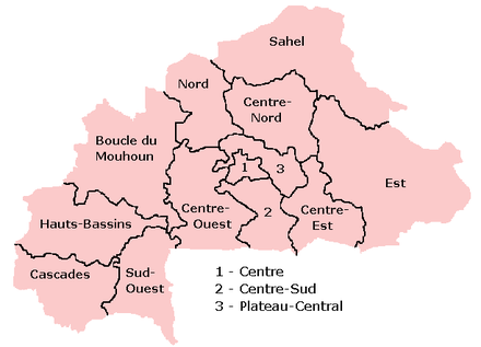

Burkina Faso is divided into thirteen regions, forty-five provinces, and 301 departments. The regions are:
- Boucle du Mouhoun
- Cascades
- Centre
- Centre-Est
- Centre-Nord
- Centre-Ouest
- Centre-Sud
- Est
- Hauts-Bassins
- Nord
- Plateau-Central
- Sahel
- Sud-Ouest
Military, police and security forces
The country employs numerous police and security forces, generally modeled after organizations used by French police, and France continues to provide significant support and training to police forces in Burkina Faso. The Gendarmerie Nationale is organized along military lines, with most police services delivered at the brigade level. The Gendarmerie operates under the authority of the Minister of Defence, and its members are employed chiefly in the rural areas and along borders.
There is also a municipal police force controlled by the Ministry of Territorial Administration; a national police force controlled by the Ministry of Security; and an autonomous Presidential Security Regiment (Régiment de la Sécurité Présidentielle, or RSP), a ‘palace guard’ devoted to the protection of the President of the Republic. Both the gendarmerie and the national police are subdivided into both administrative and judicial police functions; the former are detailed to protect public order and provide security, the latter are charged with criminal investigations.
All foreigners and citizens are required to carry photo ID passports, or other forms of identification or risk a fine, and police spot identity checks are commonplace for persons traveling by auto, bush-taxi, or bus.
The army consists of some 6,000 men in voluntary service, augmented by a part-time national People's Militia composed of civilians between 25 and 35 years of age who are trained in both military and civil duties. According to Jane’s Sentinel Country Risk Assessment, Burkina Faso's Army is undermanned for its force structure and poorly equipped, but has numbers of wheeled light-armour vehicles, and may have developed useful combat expertise through interventions in Liberia and elsewhere in Africa.
In terms of training and equipment, the regular Army is believed to be neglected in relation to the élite Presidential Security Regiment (RSP). Reports have emerged in recent years of disputes over pay and conditions. There is an air force with some 19 operational aircraft, but no navy, as the country is landlocked. Military expenses constitute approximately 1.2% of the nation’s GDP.
In April 2011, there was an army mutiny; the president named new chiefs of staff, and a curfew was imposed in Ouagadougou.
Geography and climate


Burkina Faso lies mostly between latitudes 9° and 15°N (a small area is north of 15°), and longitudes 6°W and 3°E.
It is made up of two major types of countryside. The larger part of the country is covered by a peneplain, which forms a gently undulating landscape with, in some areas, a few isolated hills, the last vestiges of a Precambrian massif. The southwest of the country, on the other hand, forms a sandstone massif, where the highest peak, Ténakourou, is found at an elevation of 749 meters (2,457 ft). The massif is bordered by sheer cliffs up to 150 meters (492 ft) high. The average altitude of Burkina Faso is 400 meters (1,312 ft) and the difference between the highest and lowest terrain is no greater than 600 meters (1,969 ft). Burkina Faso is therefore a relatively flat country.
The country owes its former name of Upper Volta to three rivers which cross it: the Black Volta (or Mouhoun), the White Volta (Nakambé) and the Red Volta (Nazinon). The Black Volta is one of the country's only two rivers which flow year-round, the other being the Komoé, which flows to the southwest. The basin of the Niger River also drains 27% of the country's surface.
The Niger's tributaries – the Béli, the Gorouol, the Goudébo and the Dargol – are seasonal streams and flow for only four to six months a year. They still can flood and overflow, however. The country also contains numerous lakes – the principal ones are Tingrela, Bam and Dem. The country contains large ponds, as well, such as Oursi, Béli, Yomboli and Markoye. Water shortages are often a problem, especially in the north of the country.

Burkina Faso has a primarily tropical climate with two very distinct seasons. In the rainy season, the country receives between 600 and 900 millimeters (23.6 and 35.4 in) of rainfall; in the dry season, the harmattan – a hot dry wind from the Sahara – blows. The rainy season lasts approximately four months, May/June to September, and is shorter in the north of the country. Three climatic zones can be defined: the Sahel, the Sudan-Sahel, and the Sudan-Guinea. The Sahel in the north typically receives less than 600 millimeters (23.6 in) of rainfall per year and has high temperatures, 5–47 degrees Celsius (41–116.6 °F).
A relatively dry tropical savanna, the Sahel extends beyond the borders of Burkina Faso, from the Horn of Africa to the Atlantic Ocean, and borders the Sahara to its north and the fertile region of the Sudan to the South. Situated between 11°3' and 13°5' north latitude, the Sudan-Sahel region is a transitional zone with regards to rainfall and temperature. Further to the south, the Sudan-Guinea zone receives more than 900 millimeters (35.4 in) of rain each year and has cooler average temperatures.
Burkina Faso's natural resources include manganese, limestone, marble, phosphates, pumice, salt and small deposits of gold.
Burkina Faso's fauna and flora are protected in two national parks and several reserves: see List of national parks in Africa, Nature reserves of Burkina Faso.
Economy


Burkina Faso has one of the lowest GDP per capita figures in the world: $1,200. Agriculture represents 32% of its gross domestic product and occupies 80% of the working population. It consists mostly of livestock but also, especially in the south and southwest, of growing sorghum, pearl millet, maize (corn), peanuts, rice and cotton. A large part of the economic activity of the country is funded by international aid.
Burkina Faso was ranked the 111th safest investment destination in the world in the March 2011 Euromoney Country Risk rankings.
Remittances used to be an important source of income to Burkina Faso until the 1990s, when unrest in Côte d'Ivoire, the main destination for Burkinabe emigrants, forced many to return home. Remittances now account for less than 1% of GDP.
Burkina Faso is part of the West African Monetary and Economic Union (UMEOA) and has thus adopted the CFA Franc, which is issued by the Central Bank of the West African States (BCEAO), situated in Dakar, Senegal. The BCEAO is not only responsible for the monetary and reserve policy of the member states, but also for the regulation and oversight of financial sector and banking activity. A legal framework regarding licensing, bank activities, organizational and capital requirements, inspections and sanctions (all applicable to all countries of the Union) is in place and underwent significant reforms in 1999. Micro-finance institutions are governed by a separate law, which regulates micro-finance activities in all WAEMU countries. The insurance sector is regulated through the Inter-African Conference on Insurance Markets (CIMA).
There is mining of copper, iron, manganese, gold, cassiterite (tin ore), and phosphates. These operations provide employment, international aid, and in some cases hospitals at mines for the public. Gold production increased 32% in 2011 at six gold mine sites, making Burkina Faso the fourth largest gold producer in Africa, after South Africa, Mali and Ghana.
Burkina Faso also hosts the International Art and Craft Fair, Ouagadougou, better known by its French name as SIAO, Le Salon International de l' Artisanat de Ouagadougou, one of the most important African handicraft fairs.
Burkina Faso is a member of the Organization for the Harmonization of Business Law in Africa (OHADA).
While services remain underdeveloped, one state-owned utility company run along commercial lines is emerging as one of the best performing utility companies in Africa, the National Office for Water and Sanitation (ONEA). High levels of autonomy and a skilled and dedicated management has driven ONEA's ability to improve production of and access to water. Since 2000, nearly 2 million more people have access to water in the four principal urban centres in the country while at the same time keeping the quality of infrastructure high (less than 18% of the water is lost through leaks – one of the lowest in sub-Saharan Africa), improving financial reporting and an average 12% annual revenue increase (well above inflation). Challenges remain, including some customers' ability to pay and a reliance on aid for the expansion of its infrastructure. However, the state-owned commercially run venture has helped lead Burkina Faso's Millennium Development Goal (MDG) targets in its water-related targets and grow as a viable company.
Demographics

Burkina Faso's 15.3 million people belong to two major West African cultural groups—the Voltaic and the Mande (whose common language is Dioula). The Voltaic Mossi make up about one-half of the population. The Mossi claim descent from warriors who migrated to present-day Burkina Faso from Ghana and established an empire that lasted more than 800 years. Predominantly farmers, the Mossi kingdom is still led by the Mogho Naba, whose court is in Ouagadougou.
Burkina Faso is an ethnically integrated, secular state. Most of Burkina's people are concentrated in the south and centre of the country, sometimes exceeding 48 per square kilometer (125/sq. mi.). Hundreds of thousands of Burkinabe migrate to Côte d'Ivoire and Ghana, many for seasonal agricultural work. These flows of workers are obviously affected by external events; the September 2002 coup attempt in Côte d'Ivoire and the ensuing fighting there have meant that hundreds of thousands of Burkinabe returned to Burkina Faso.
The total fertility rate of Burkina Faso is 6.07 children born per woman (2012 estimates), the sixth highest in the world.
The practice of slavery in Burkina Faso, as in the Sahel states in general, is an entrenched phenomenon with a long history, going back to the Arab slave trade, and it continues today.
Health
Average life expectancy at birth in 2004 was estimated at 52 for females and 50 for males. The median age of its inhabitants is 16.7. The estimated population growth rate is 3.109%.
Central government spending on health was 3% in 2001. As of 2009, it was estimated that there were as few as 10 physicians per 100,000 people. In addition, there were only 41 nurses and 13 midwives per 100,000 people. Demographic and Health Surveys has completed three surveys in Burkina Faso since 1993 and is currently in the process of performing another.
In 2009, it was estimated that the adult HIV prevalence rate (ages 15–49) was 1.2%. According to the 2011 UNAIDS Report, HIV prevalence is declining among pregnant women who attend antenatal clinics.
According to a 2005 World Health Organization report, an estimated 72.5% of Burkina Faso's girls and women have suffered female genital mutilation.
Religion


Statistics on religion in Burkina Faso are inexact because Islam and Christianity are often practiced in tandem with indigenous religious beliefs. The Government of Burkina Faso stated in its most recent census (2006) that 60.5% of the population practice Islam, and that the majority of this group belong to the Sunni branch, while a growing minority adheres to the Shi'a branch (reference missing). A significant number of Sunni Muslims identify with the Tijaniyah Sufi order. The Government also estimated that some 23.2% are Christians (19% being Roman Catholics and 4.2% members of various Protestant denominations), 15.3% follow Traditional indigenous beliefs, 0.6% have other religions, and 0.4% have none (atheism is virtually nonexistent).
A popular saying in Burkina Faso claims that "50% are Muslim, 50% are Christian, and 100% are animist". This shows the large level of acceptance of the various religions amongst each other. Even for Muslims and Christians, ancient animist rites are still highly valued. The Great Mosque of Bobo-Dioulasso was built by people of different faiths working together.
Education

Education in Burkina Faso is divided into primary, secondary and higher education. However schooling costs approximately CFA 50,000 ($97 USD) per year, which is far above the means of most Burkinabè families. Boys receive preference in schooling; as such, girls' education and literacy rates are far lower than their male counterparts. An increase in girls' schooling has been observed because of the government's policy of making school cheaper for girls and granting them more scholarships. In order to proceed from elementary to middle school, middle to high school or high school to college, national exams must be passed. Institutions of higher education include the University of Ouagadougou, The Polytechnical University in Bobo-Dioulasso and the University of Koudougou, which is also a teacher training institution. There are private colleges in the capital city of Ouagadougou but these are affordable by only a small portion of the population.
There is also the International School of Ouagadougou (ISO), an American-based private school located in Ouagadougou.
The UN Development Program Report ranks Burkina Faso as the country with the lowest level of literacy in the world, despite a concerted effort to double its literacy rate from 12.8% in 1990 to 25.3% in 2008.