Colima (volcano)
Did you know...
SOS Children offer a complete download of this selection for schools for use on schools intranets. Sponsor a child to make a real difference.
| Volcán de Colima | |
|---|---|
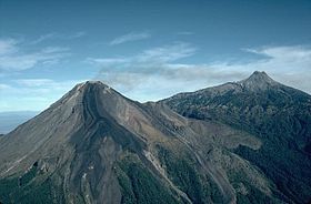
 Volcán de Colima is on the left with Nevado de Colima on the right |
|
| Elevation |
Volcan de Colima: 3,820 Nevado de Colima 4,339 m (Invalid value ft) |
| Prominence |
Volcan de Colima: 570 Nevado de Colima: 2,720 m (Invalid value ft) |
| Location | |
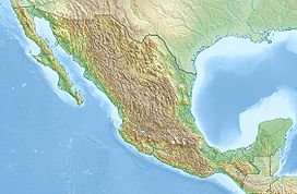
| Location in Mexico | |
| Location | Jalisco / Colima, Mexico |
| Range | Eje Volcánico Transversal |
| Coordinates | 19°30′46″N 103°37′02″W Coordinates: 19°30′46″N 103°37′02″W |
| Geology | |
| Type | Stratovolcano |
| Age of rock | 5 million years |
| Volcanic arc/ belt | Trans-Mexican Volcanic Belt |
| Last eruption | 2013 |
The Volcán de Colima, also known as Volcán de Fuego is part of the Colima volcanic complex consisting of Volcán de Colima and Nevado de Colima. It is the younger of the two and is currently one of the most active volcanos in Mexico and in North America. It has erupted more than 40 times since 1576. One of the largest eruptions was on January 20–24, 1913. Nevado de Colima, also known as Tzapotépetl, lies 5 kilometres (3.1 mi) north its more active neighbour and is the taller of the two at 4,271+ meters (14,015+ ft). It is the 26th most prominent peak in North America.
Despite its name, only a fraction of the volcano's surface area is in the state of Colima; the majority of its surface area lies over the border in the neighboring state of Jalisco, toward the western end of the Eje Volcánico Transversal mountain range. It is about 485 km (301 mi) west of Mexico City and 125 km (78 mi) south of Guadalajara, Jalisco.
Since 1869-1878, a parasitic set of domes, collectively known as El Volcancito, have formed on the northeast flank of the main cone of the volcano.
Geological history
In the late Pleistocene era, a huge landslide occurred at the mountain, with approximately 25 km³ of debris travelling some 120 km, reaching the Pacific Ocean. An area of some 2,200 km² was covered in landslide deposits.The currently active cone is situated within a large caldera that was probably formed by a combination of landslides and large eruptions. About 300,000 people live within 40 km (2.5 miles) of the volcano, which makes it the most dangerous volcano in Mexico. In light of its history of large eruptions and situation in a densely populated area, it was designated a Decade Volcano, singling it out for study.
Current activity
In recent years there have been frequent temporary evacuations of nearby villagers due to threatening volcanic activity. Eruptions have occurred in 1991, 1998–1999 and from 2001 to the present day, with activity being characterised by extrusion of viscous lava forming a lava dome, and occasional larger explosions, forming pyroclastic flows and dusting the areas surrounding the volcano with ash and tephra.
The largest eruption for several years occurred on May 24, 2005. An ash cloud rose to over 3 km over the volcano, and satellite monitoring indicated that the cloud spread over an area extending 110 nautical miles (200 km) west of the volcano in the hours after the eruption . Pyroclastic flows travelled four-five km from the vent, and lava bombs landed 3–4 km away. Authorities set up an exclusion zone within 6.5 km of the summit.
On June 8, 2005, the volcano erupted again in its largest recorded eruption in several decades. Plumes from this eruption reached heights of 5 km (>3 miles) above the crater rim, prompting the evacuation of at least three neighboring villages.


