Geography of Sierra Leone
Background to the schools Wikipedia
SOS Children, which runs nearly 200 sos schools in the developing world, organised this selection. Click here for more information on SOS Children.
| Geography of Sierra Leone | |
|---|---|
 |
|
| Continent | Africa |
| Region | Western Africa |
| Coordinates | 8°30′N 11°30′W |
| Area | Ranked 119th 71,740 km2 (27,700 sq mi) |
| Borders | Guinea, Liberia |
| Highest point | Mount Bintumani 1,948 m (6,391 ft) |
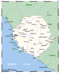
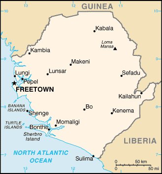
Sierra Leone is located on the west coast of Africa, between the 7th and 10th parallels north of the equator. Sierra Leone is bordered by Guinea to the north and northeast, Liberia to the south and southeast, and the Atlantic Ocean to the west. The country has a total area of 71,740 km2 (27,699 sq mi), divided into a land area of 71,620 km2 (27,653 sq mi) and water of 120 km2 (46 sq mi). The country has four distinct geographical regions: coastal Guinean mangroves, the wooded hill country, an upland plateau, and the eastern mountains. Eastern Sierra Leone is an interior region of large plateaus interspersed with high mountains, where Mount Bintumani rises to 1,948 meters (6,391 ft).
Climate
The climate is tropical, with two seasons determining the agricultural cycle: the rainy season from May to November, and a dry season from December to May, which includes harmattan, when cool, dry winds blow in off the Sahara Desert and the night-time temperature can be as low as 16 °C (60.8 °F). The average temperature is 26 °C (78.8 °F) and varies from around 26 °C (78.8 °F) to 36 °C (96.8 °F) during the year.
General information
Geographic coordinates: 8°30′N 11°30′W
Area:
total: 71,740 km²
land: 71,620 km²
water: 120 km²
Land boundaries:
total: 958 km
border countries: Guinea 652 km, Liberia 306 km
Coastline: 402 km
Maritime claims:
territorial sea: 200 nmi (370.4 km; 230.2 mi).
continental shelf: 200 m depth or to the depth of exploitation.
Climate: tropical; hot, humid; summer rainy season (May to December); winter dry season (December to April).
Terrain: coastal belt of mangrove swamps, wooded hill country, upland plateau, mountains in east.
Elevation extremes:
lowest point: Atlantic Ocean 0 m
highest point: Loma Mansa (Bintimani) 1,948 m
Natural resources: diamonds, titanium ore, bauxite, iron ore, gold, chromite.
Land use:
arable land: 7%
permanent crops: 1%
permanent pastures: 31%
forests and woodland: 28%
other: 33% (1993 est.)
Irrigated land: 290 km²; (1998, 1993 est.)
Natural hazards: dry, sand-laden harmattan winds blow from the Sahara (November to May); dust storms.
Environment issues: rapid population growth pressuring the environment; overharvesting of timber, expansion of cattle grazing and slash and burn agriculture have resulted in deforestation and soil exhaustion; civil war depleting natural resources; overfishing.
Environmental agreements:
Party to:
- Biodiversity (Convention on Biological Diversity)
- Climate Change (United Nations Framework Convention on Climate Change)
- Desertification (United Nations Convention to Combat Desertification)
- Endangered Species (CITES)
- Law of the Sea(UNCLOS or LOS)
- Marine Life Conservation (Convention on Fishing and Conservation of Living Resources of the High Seas)
- Nuclear Test Ban(CTBT)
- Wetlands(Ramsar Convention)
Signed, but not ratified:
- Environmental Modification(ENMOD)


