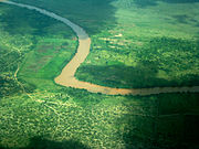
Jubba River
About this schools Wikipedia selection
This Wikipedia selection is available offline from SOS Children for distribution in the developing world. SOS Children is the world's largest charity giving orphaned and abandoned children the chance of family life.
| Jubba River | |
|---|---|
| Origin | Confluence of Dawa River and Ganale Dorya River at 4.1771°N 42.0809°E |
| Mouth | 0.2495°S 42.6307°E Coordinates: 0.2495°S 42.6307°E into Indian Ocean |
| Basin countries | Somalia, Ethiopia |
The Jubba River ( Somali: Webi Jubba) is a river in southern Somalia which begins at the border with Ethiopia where the Dawa and Ganale Dorya rivers meet, and flows directly south to the Indian Ocean, where it empties to the ocean at Goobweyn.
The Jubba basin region is primarily savanna, and is the richest part of the country due to its fertile farmland. Native wild life include giraffes, cheetahs, lions, leopards, hyenas, buffalos, hippopotamus, crocodiles, oryx, gazelles, camels, ostriches, jackals, and wild donkeys.
The Jubba River gives its name to the Somali administrative regions of Middle Juba and Lower Juba as well as to the larger historical region of Jubaland. Major cities which the Jubba River passes by include Doollow, Luuq, Buurdhuubo, Beledhawo, Baardheere, Saakow and Goobweyn near Kismaayo.
History
The earliest European to record his visit to the Jubba area is the Jesuit Jerónimo Lobo, who, in 1624, attempted to follow the course of the Jubba into Ethiopia only to learn that he would need to pass through the lands of nine different peoples who "were continuously at war with one another and each one was scarcely secure in its own land than thus could not provide security for anyone who took a step outside of it", and returned to Portuguese India to find another way there.
Over two centuries passed until Baron Karl Klaus von der Decken ascended the lower reaches of the river on the small steamship Welf in 1863. He wrecked the steamship in the rapids above Baardheere, where the party was attacked by local Somalis, ending in the deaths of the Baron and three others in his party. The next European to explore the river was Commander Dundas of the British Navy, who sailed 400 miles of the river in 1891.
Floods
The area receives some of the most rainfall in Somalia; the Gu' rainy season normally occurs between late March through May. Years in which Jubba River has flooded include 1960, which caused a great loss of life. The Dyr rainy season during October through December 1997 was devastating. The combination of the Jubba breaking its banks and nearly two months of continuous rain led to historic levels of livestock lost and other damages.
The floods of 1997 were known as the Deyrtii Biyobadan, which roughly translates as The Watery Fall. The Bardera region is situated in the Jubba Valley enclave, and thus is prone to flooding during the rainy season.
During the 1997 devastating rainy season, livestock from all of the regions along the Jubba -- Gedo, Middle and Lower Jubba -- were herded from the low-lying grazing areas to the mountainous areas of Gedo for safekeeping out of heavy floods on. Despite this, many families lost their herds from the flooding due to rain, night colds and skin diseases caused by continuous wetness. Camel herders suffered the greatest losses because the camels' flat feet got wet and were easily torn by stones, rocks and sticks on the ground. Foot infection became common. Lastly, the camels' soft and fatty chest area, good for weight distribution when seated, got wet and led to open sores which ultimately caused the animal's death.


