

Lake Assal (Djibouti)
Background to the schools Wikipedia
This content from Wikipedia has been selected by SOS Children for suitability in schools around the world. SOS Child sponsorship is cool!
| Lake Assal | |
|---|---|
 |
|
| Location | Afar Depression |
| Coordinates | 11°39′N 42°25′E Coordinates: 11°39′N 42°25′E |
| Lake type | crater lake |
| Primary inflows | subsurface from the ocean |
| Primary outflows | none |
| Catchment area | 900 km2 (350 sq mi) |
| Basin countries | Djibouti |
|
|
|
| Max. length | 10 km (6.2 mi) |
| Max. width | 7 km (4.3 mi) |
| Surface area | 54 km2 (21 sq mi) |
| Average depth | 7.4 m (24 ft) |
| Max. depth | > 20 m (66 ft) |
| Water volume | 400 million cubic metres (320,000 acre·ft) |
| Surface elevation | −155 m (−509 ft) |
|
|
|
| Settlements | Randa (25 km or 16 mi northeast) |
Lake Assal (French: Lac Assal) is a crater lake in central Djibouti, located at the southern border of Tadjoura Region, touching Dikhil Region, some 120 km (75 mi) west of Djibouti city. It lies 155 m (509 ft) below sea level in the Afar Depression and its shores comprise the lowest point on land in Africa and the second lowest land depression on Earth after the Dead Sea. It measures 19 by 7 km (4.3 mi) and has an area of 54 km2 (21 sq mi). The maximum depth is 40 m (130 ft), whereas the mean depth is 7.4 m (24 ft), which makes for a water volume of 400 million cubic metres (320,000 acre·ft). The catchment area measures 900 km2 (350 sq mi), and there is just a residual runoff of fresh water into the lake.
Lake Assal is considered the most saline body of water on earth outside Antarctica, with 34.8 percent salt concentration (up to 40% at 20 m (66 ft) depth), compared to Garabogazköl or the 33.7 percent level in the Dead Sea (often incorrectly considered the world's most saline lake), and an average of 3.5 percent in the world's oceans. Only some hypersaline lakes of the McMurdo Dry Valleys in Antarctica such as Don Juan Pond have a higher salinity. The sources of the lake are hot springs whose salinity is close to sea water, which are fed by the Gulf of Tadjoura (French: Golfe de Tadjoura), the western extension of the Gulf of Aden, specifically the nearly closed-off bay Ghoubet Kharab, about 10 km southeast of the lake.
The area is wild and desert-like, and no fauna or flora can be seen in the syrupy waters of the lake. The high temperature of the water (33-34 °C) favors evaporation, and it is surrounded by a salt pan (extending west and mainly northwest). The salt is mined and transported by caravan to Ethiopia.
-
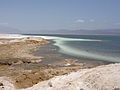
Lake Assal, with the salt pan on the left
-
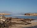
Lake Assal
-
-
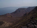
Bay of Goudouk
-


