Palestinian territories
Background to the schools Wikipedia
SOS Children produced this website for schools as well as this video website about Africa. A good way to help other children is by sponsoring a child
| Palestinian territories | ||
|---|---|---|
|
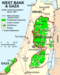
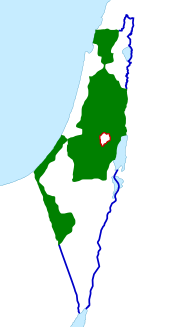
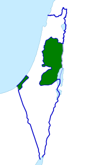
Green: Areas of Palestinian National Authority control (in the West Bank) and Hamas government control (Gaza Strip) as of 2007.
|
||
| Largest cities |
|
|
| Demonym |
|
|
| Establishment | ||
| - | Israeli occupation established | 1967 |
| Area | ||
| - | Total | 6,220 km2
2,402 sq mi |
| - | Water (%) | 3.5 |
| Population | ||
| - | 2012 estimate | 4,293,313 |
| - | 2007 census | 3,719,189 |
| - | Density | 654/km2 1,694/sq mi |
| HDI (2010) | 0.645 medium · 97th |
|
| Currency |
JOD, EGP, ILS) |
|
| Time zone | ( UTC+2) | |
| - | Summer ( DST) | ( UTC+3) |
| Calling code | +970d | |
| Internet TLD |
|
|
| a. | Used in West Bank since 1950. | |
| b. | Used in Gaza Strip since 1951. | |
| c. | Used since 1985. | |
| d. | +972 also used. | |
The Palestinian territories or occupied Palestinian territories (OPT or oPt) comprise the West Bank (including East Jerusalem) and the Gaza Strip. In 1993, following the Oslo Accords, parts of the territories politically came under the jurisdiction of the Palestinian National Authority (Areas A and B). In 2007, the Hamas-ruled Gaza Strip violently split from the Palestinian Authority, governing the area of Gaza independently since. Israel still exercises full military control and Israeli civil control over 61% of the West Bank ( Area C). In April 2011, the Palestinian parties signed an agreement of reconciliation, but its implementation has stalled since. Subsequent reconciliation efforts in 2012 did not succeed either.
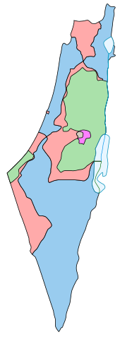
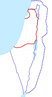
The areas of the West Bank and the Gaza Strip were part of the territory west of the Jordan River of Mandatory Palestine under British governance, formed in 1922. From the 1948 Arab–Israeli War until the 1967 Six Day War, the West Bank was occupied and annexed by Jordan (annexation recognized only by UK and Pakistan) and the Gaza Strip occupied by Egypt, though limited authority had been exercised in Gaza by the All-Palestine Government from September 1948 until 1959. The borders of the Palestinian territories are currently considered to be delineated by the 1949 Armistice Agreements.
Since Israel captured the West Bank and Gaza Strip from Jordan and Egypt in 1967, the international community, including the UN and international legal bodies, has often referred to those areas as the occupied Palestinian territories.
In 1980, Israel officially annexed East Jerusalem. The annexation was condemned internationally and declared "null and void" by the United Nations Security Council. In 1988, with the Palestine Liberation Organization (PLO) intention to declare a Palestinian State, Jordan renounced all territorial claims to East Jerusalem and the West Bank. Since the Palestinian Declaration of Independence in 1988, some 130 UN Member Nations have recognized the State of Palestine, comprising the Palestinian territories. It has not been recognized by Israel and some Western nations, including the United States. Shortly, however, the Palestinian Authority was formed in the outcome of the 1993 Oslo Accords, exercising limited control over parts of the West Bank and the Gaza Strip.
The Palestinian National Authority, the United Nations Security Council, the United Nations General Assembly, the European Union, the International Court of Justice, and the International Committee of the Red Cross regard East Jerusalem as part of the West Bank, and consequently a part of the Palestinian territories, while Israel regards it as part of Israel as a result of its annexation in 1980. According to the Israeli Supreme Court, the Fourth Geneva Convention, which prohibits unilateral annexation of occupied territory, does not apply to East Jerusalem, as there was no "legitimate sovereign" there previously. The Palestinian National Authority, which maintains a territorial claim to East Jerusalem, never exercised sovereignty over the area. Israeli sovereignty, however, has not been recognized by any country, since unilateral annexation of territory conquered during war contravenes the Fourth Geneva Convention. The Oslo Accords (1995) established access to the sea for Gaza within 20 nautical miles from the shore. The Berlin Commitment of 2002 reduced this to 12 miles. In October 2006 Israel imposed a 6-mile limit, and at the conclusion of the Gaza War restricted access to a 3-nautical-mile limit, beyond which a no-go zone exists. As a result, over 3,000 fishermen are denied access to 85% of the maritime areas agreed to in 1995. The majority of the Dead Sea area is off-limits to Palestinian use, and Palestinians are denied access to its coast line.
The Hamas takeover of Gaza divided the Palestinian territories politically, with Abbas’s Fatah left largely ruling the West Bank and recognized internationally as the official Palestinian Authority. Both the West Bank and the Gaza Strip are often still considered to be occupied by Israel, according to the international community. The Gaza Strip within the borders is governed by Hamas, while much of the West Bank is governed by the Ramallah-based Palestinian National Authority.
Name
There are disagreements over what the Palestinian territories should be called.
The United Nations, the European Union, International Committee of the Red Cross and the government of the United Kingdom all refer to the "Occupied Palestinian Territories".
The International Court of Justice refers to the West Bank and East Jerusalem as "the Occupied Palestinian Territory" and this term has the legal definition of the International Court of Justice following the ruling in July 2004 .
Journalists also use the description to indicate lands outside the Green Line. The term is often used interchangeably with the term occupied territories, although this term is also applied to the Golan Heights, which is internationally recognized as part of Syria and not claimed by the Palestinians. The confusion stems from the fact that all these territories were captured by Israel during the 1967 Six-Day War and are treated by the UN as territory occupied by Israel.
Other terms used to describe these areas collectively include "the disputed territories", and " Israeli-occupied territories". Further terms include "Palestine", " State of Palestine", " Yesha" (Judea-Samaria-Gaza), "Yosh" (Judea and Samaria), the "Katif Strip" (Gaza Strip), "Palestinian Autonomous Areas" (although this term is also used to specifically refer to Area's A and B), "Palestinian Administered Territories", " administered territories", "territories of undetermined permanent status", "1967 territories", and simply "the territories".
Many Arab and Islamic leaders, including some Palestinians, use the designation "Palestine" and "occupied Palestine" to imply a Palestinian political or religious claim to sovereignty over the whole former territory of the British Mandate west of the Jordan River, including all of Israel. Many of them view the land of Palestine as an Islamic Waqf (trust) for future Muslim generations. A parallel exists in the aspirations of David Ben-Gurion, Menachem Begin, and other Zionists and Jewish religious leaders to establish Jewish sovereignty over all of Greater Israel in trust for the Jewish people. However, this dispute is not related to religion for many Arabs, but simply an issue of rights, as the land was inhabited by Arabs (as well as a minority of Jews) before the Zionist movement began.
Many Israelis object to the term "Occupied Palestinian Territories" and similar descriptions because they maintain such designations disregard Israeli claims to the West Bank and Gaza, or prejudice negotiations involving possible border changes, arguing that the armistice line agreed to after the 1948 Arab-Israeli War was not intended as a permanent border. Dore Gold wrote, "It would be far more accurate to describe the West Bank and Gaza Strip as "disputed territories" to which both Israelis and Palestinians have claims."
Boundaries
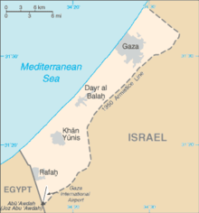
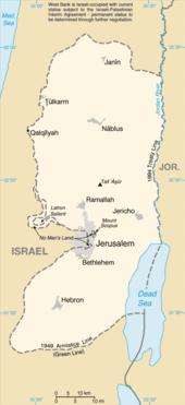
The Palestinian Territories consist of two distinct areas: the West Bank, including East Jerusalem and the Gaza Strip. The boundaries are defined by the "1967 borders", which correspond with the Green Line. The Green Line represents the armistice lines under the 1949 Armistice Agreements, which brought an end to the 1948 Arab-Israeli War and expressly declared armistice lines, not international borders. Some Palestinian negotiators have claimed a return to those lines as the boundary for a future Palestinian state, while Hamas does not recognize the State of Israel at all. The Arab League has supported these boundaries as the borders of the future State of Palestine in the 2002 Arab Peace Initiative.
The eastern limit of the West Bank is the border with Jordan. The Israel–Jordan peace treaty defined that border as the international border, and Jordan renounced all claims to territory west of it. The border segment between Jordan and the West Bank was left undefined pending a definitive agreement on the status of the territory.
The southern limit of the Gaza Strip is the border with Egypt. Egypt renounced all claims to land north of the international border, including the Gaza Strip, in the Israel-Egypt peace treaty. The Palestinians were not parties to either agreement.
The Gaza Strip is bounded by the Mediterranean Sea. The natural geographic boundary of the West Bank, as the name implies, is the Jordan River. To the Territories belong the territorial waters of the Gaza Strip and the part of the Dead Sea between the West Bank and the Jordan border-line (see adjacent CIA-map), which are also completely controlled by Israel.
Future Palestinian state
The Palestinian territories are part of the area intended by the United Nations to become the territory of the future State of Palestine. Originally a larger area was allotted to the planned Palestinian state in Resolution 181 of 29 November 1947, but in the 1948 Palestine war, the Israeli army conquered major parts of it. While in the Partition Plan about 42% of historic Palestine was destined for the Arabic state, the Palestinian territories constitute only some 23%. The last figure is including all space occupied by Israeli settlements, walls and roads.
In the UN, nearly all countries voted in favour of Resolution 58/292 of 17 May 2004; namely, that the boundaries of a future Palestinian state should be based on the pre-1967 borders, which correspond with the Green Line. The Resolution affirmed, in connection with the Palestinian right to self-determination and to sovereignty, that the independent State of Palestine should be based on the pre-1967 borders. In Resolution 43/177 of 15 December 1988, the declaration of independence of the State of Palestine was acknowledged by the UN General Assembly, but it was not admitted as a member state. In the same resolution, their sovereignty over the Occupied Palestinian Territories was recognized.
On 29 November 2012, the UN General Assembly passed United Nations General Assembly resolution 67/19 changing Palestine's "entity" status to "non-member state" by a vote of 138 to 9, with 41 abstentions.
East Jerusalem
In 1980, Israel annexed East Jerusalem. The annexation lacks international recognition. Seven UNSC resolutions, including United Nations Security Council Resolution 478 declared it "null and void" and required that it be rescinded, stating that it was a violation of international law (the 4th Geneva Convention). The United Nations never explicitly recognized Jerusalem as part of either Israel or Palestine, as Resolution 181 (1947) was never revoked. In Resolution 181, Jerusalem was intended to become a corpus separatum under international regime. Nevertheless, most countries, including the US, implicitly recognize West Jerusalem as part of Israel, but do not recognize Jerusalem as Israel's capital.
Palestinians regard East Jerusalem as the capital of the future Palestinian state. East Jerusalem is generally recognized as part of the Palestinian Territories. In UN resolutions concerning Israel, East Jerusalem is routinely referred to as part of the West Bank or as part of the Palestinian Territories.
Gaza Strip
In 2005, Israel pulled all its remaining forces out of the Gaza Strip and dismantled its settlements. Nevertheless, according to the international community, the Gaza Strip is still considered to be occupied by Israel. Israel has denied that it occupies the Gaza Strip, but the borders of the Gaza Strip, including coast and airspace, are completely controlled by Israel. The UN Special Rapporteur on the situation of human rights in the Palestinian territories occupied since 1967 stated in 2007:
"Israel remains an occupying Power in respect of Gaza. Arguments that Israel ceased its occupation of Gaza in 2005 following the evacuation of its settlements and the withdrawal of its troops take no account of the fact that Israel retains effective control over Gaza by means of its control over Gaza’s external borders, airspace, territorial waters, population registry, tax revenues and governmental functions. The effectiveness of this control is emphasized by regular military incursions and rocket attacks."
Political status
The political status of the territories has been the subject of negotiations between Israel and the PLO and of numerous statements and resolutions by the United Nations. (See List of United Nations resolutions concerning Israel.) Since 1994, the autonomous Palestinian National Authority has exercised various degrees of control in large parts of the territories, as a result of the Declaration of Principles contained in the Oslo Accords. The United States government considers the West Bank and Gaza as a single entity for political, economic, legal and other purposes. The State Department and other US government agencies, such as USAID West Bank and Gaza, have been tasked with projects in the areas of democracy, governance, resources, and infrastructure. Part of the USAID mission is to provide flexible and discrete support for implementation of the Quartet Road Map. The Road Map is an internationally backed plan that calls for the progressive development of a viable Palestinian State in the West Bank and Gaza. Participating states provide assistance through direct contributions or through the Palestinian State account established by the World Bank.
After Hamas won a majority of seats in elections for the Palestinian Parliament, the United States and Israel instituted an economic blockade of the Gaza Strip. When that failed to topple the new government, a covert operation was launched to eliminate Hamas by force. The covert initiative was exposed when confidential State Department documents were accidentally leaked by the US envoy. The talking points delivered to the Fatah leadership said:
Hamas should be given a clear choice, with a clear deadline: they either accept a new government that meets the Quartet principles, or they reject it. The consequences of Hamas’ decision should also be clear: If Hamas does not agree within the prescribed time, you should make clear your intention to declare a state of emergency and form an emergency government explicitly committed to that platform.
Since the Battle of Gaza (2007), the administration of the territories has been contested by two rival factions of the Palestinian National Authority, with Hamas controlling the Gaza Strip and Fatah continuing to administer the West Bank. Both groups claim legitimacy over leadership of the Palestinian territories. Most countries with an interest in the issues, including most of the Arab countries, recognize the administration of Mahmoud Abbas as the legitimate government over both Palestinian Territories.
During Operation Cast Lead the UN Security Council adopted Resolution 1860 (2009), which said that the Gaza Strip constitutes an integral part of the territory occupied in 1967 that will be a part of the Palestinian state.
On 15 December 2011, Iceland recognized Palestine as an independent and sovereign state within the pre-1967 Six Day War borders; Össur Skarphéðinsson, Minister for Foreign Affairs of Iceland, and Dr. Riad Malki, the Foreign Minister of Palestine, formally confirmed the establishment of full diplomatic relations between Iceland and Palestine.
Legal status
The international community regards the West Bank and East Jerusalem as territories occupied by Israel. Israel has withdrawn its military forces from the Gaza strip, but it continues to be designated the occupying power in the Gaza Strip by the United Nations, the United States and various human rights organizations. However, the co-founder of Hamas, Mahmoud Zahar, has stated that Gaza is no longer occupied since the Israeli withdrawal. The final status of the Palestinian Territories as an independent state is supported by the countries that form the Quartet's " Road map for peace". The government of Israel has also accepted the road map but with 14 reservations.
On Thursday, November 29, 2012, In a 138-9 vote (with 41 abstaining) General Assembly resolution 67/19 passed, upgrading Palestine to "non-member observer state" status in the United Nations. The new status equates Palestine's with that of the Holy See.The change in status was described by The Independent as "de facto recognition of the sovereign state of Palestine". The vote was a historic benchmark for the partially recognised State of Palestine and its citizens, whilst it was a diplomatic setback for Israel and the United States. Status as an observer state in the UN will allow the State of Palestine to join treaties and specialised UN agencies, including the International Civil Aviation Organisation, the International Criminal Court, and other organisations for recognised sovereign nations. It shall permit Palestine to claim legal rights over its territorial waters and air space as a sovereign state recognised by the UN, and allow the Palestinian people the right to sue for control of their claimed territory in the International Court of Justice and to bring war-crimes charges against Israel in the International Criminal Court.
Customary international law, including the International Court of Justice's interpretation of the Fourth Geneva Convention in their July 2004 ruling, has been widely interpreted as prohibiting Israel from building settlements, due to its clauses prohibiting the transfer of a civilian population into an occupied territory. This was reaffirmed December 5, 2001, at the Conference of High Contracting Parties to the Fourth Geneva Convention. The participating High Contracting Parties called upon Israel "to fully and effectively respect the Fourth Geneva Convention in the Occupied Palestinian Territory, including East Jerusalem, and to refrain from perpetrating any violation of the Convention. They reaffirm the illegality of the settlements in the said territories and of the extension thereof." Article 47 of the Fourth Geneva Convention prohibits any change of status in occupied territory concluded through negotiations between the occupying power and local authorities under occupation. This finding also suggests that Israel may be in violation of the Rome Statute (one of the primary legal instruments of the International Criminal Court), Article 8, section (2)(b)(viii): “The transfer, directly or indirectly, by the Occupying Power of parts of its own civilian population into the territory it occupies, or the deportation or transfer of all or parts of the population of the occupied territory within or outside this territory” see:. Given that United Nations General Assembly resolution 67/19 upgraded Palestine to non-member observer state status in November 2012, representatives of Palestine may now be able to take members of the Israeli government to the International Criminal Court under violations of the Rome Statute. On January 31, 2012 the United Nations independent "International Fact-Finding Mission on Israeli Settlements in the Occupied Palestinian Territory" filed a report stating that if Israel did not stop all settlement activity immediately and begin withdrawing all settlers from the West Bank, it potentially might face a case at the International Criminal Court, increasing credibility of any Palestinianin attempt to do so.
The UN has, after granting Palestine observer state status,, permitted Palestine to title its representative office to the UN as 'The Permanent Observer Mission of the State of Palestine to the United Nations', seen by many as a reflexion of the UN's de facto recognition of the State of Palestine's sovereignity, and Palestine has started to re-title its name accordingly on postal stamps, official documents and passports. The Palestinian authorities have also instructed its diplomats to officially represent ' The State of Palestine', as opposed to the ' Palestine National Authority'. Additionally, on 17 December 2012, UN Chief of Protocol Yeocheol Yoon decided that 'the designation of "State of Palestine" shall be used by the Secretariat in all official United Nations documents'.
Critics point out that implementation of the Oslo Accords has not improved conditions for the population under occupation. Israel contends that the settlements are not illegal as the West Bank is considered a "disputed territory" under international law. United Nations Security Council Resolution 242 recognized Israel's rights to "safe and secure borders", which has been interpreted as meaning that Israel had a right to West Bank territory for secure borders. The San Remo Conference, binding under international law, further envisioned the West Bank as being part of a sovereign Jewish state, and arguably encourages, rather than prohibits Jewish settlement in the area. Furthermore, many of the settlements were established on the sites of former Jewish communities that had existed there prior to 1947 on land that was legitimately bought, and ethnically cleansed by Arab forces. Israel views the territory as being the subject of legitimate diplomatic dispute and negotiation under international law. East Jerusalem, captured in 1967, was unilaterally annexed by Israel. The UN Security Council Resolution 478 condemned the annexation as "a violation of international law". This annexation has not been recognized by other nations, although the United States Congress declared its intention to recognize the annexation (a proposal that has been condemned by other states and organizations). Because of the question of Jerusalem's status, no states base their diplomatic missions there and treat Tel Aviv as the capital, though two states have embassies in the Jerusalem suburb of Mevaseret Zion. Israel asserts that these territories are not currently claimed by any other state, and that Israel has the right to control them.
Israel's position has not been accepted by most countries and international bodies, and the West Bank, East Jerusalem, and the Gaza Strip are referred to as occupied territories (with Israel as the occupying power) by most international legal and political bodies, the rest of the Arab bloc, the UK, including the EU, the United States,( , ), both the General Assembly and Security Council of the United Nations, the International Court of Justice, the Conference of High Contracting Parties to the Fourth Geneva Convention, and the Israeli Supreme Court (see Israeli West Bank barrier).
Former U.S. President George W. Bush stated, during his presidency, that he did not expect Israel to return entirely to pre-1967 borders, due to "new realities on the ground."
Both US President Bill Clinton and UK Prime Minister Tony Blair, who played notable roles in attempts at mediation, noted the need for some territorial and diplomatic compromise on this issue, based on the validity of some of the claims of both sides. One compromise offered by Clinton would have allowed Israel to keep some settlements in the West Bank, especially those in large blocks near the pre-1967 borders of Israel. In return, Palestinians would have received concessions of land in other parts of the country. The United Nations did not declare any change in the status of the territories as of the creation of the Palestinian National Authority between 1993 and 2000, although a 1999 U.N. document implied that the chance for a change in that status was slim at that period.
During the period between the 1993 Oslo Accords and the Second Intifada beginning in 2000, Israeli officials claimed that the term "occupation" did not accurately reflect the state of affairs in the territories. During this time, the Palestinian population in large parts of the territories had a large degree of autonomy and only limited exposure to the IDF except when seeking to move between different areas. Following the events of the Second Intifada, and in particular, Operation Defensive Shield, most territories, including Palestinian cities (Area A), are back under effective Israeli military control, so the discussion along those lines is largely moot.
In the summer of 2005, Israel implemented its unilateral disengagement plan; about 8500 Israeli citizens living in the Gaza Strip were forcibly removed from the territory; some received alternative homes and a sum of money. The Israel Defense Forces vacated Gaza in 2005, but invaded it again in 2006 in response to rocket attacks and the abduction of Israeli soldier Gilad Shalit by Hamas.
In January 2010, King Abdullah of Jordan, after a meeting with the Israeli president Shimon Peres at the World Economic Forum in Davos, declared that his country does not want to rule the West Bank and that "the two-state solution" to the Israeli-Palestinian conflict was the only viable option. If rule over the territory was to be transferred to the kingdom, it would only "replace Israeli military rule with Jordanian military rule... and the Palestinians want their own state."
In December 2010, Brazil recognized Palestine as a state with its 1967 borders. This move was later followed by Argentina, Peru, Uruguay, Bolivia and Ecuador. This action was later criticized by Israel and the United States, who labelled it "counterproductive".
Demographics
The Palestinian Central Bureau of Statistics (PCBS) estimated Palestinians at mid year 2009 as 10.7 million persons as follows: 3.9 million in the Palestinian Territory (36.6%), 1.2 million (11.5%) in Israel; 5.0 million in Arab countries (46.2%), 0.6 million in foreign countries (5.7%).
According to The Guardian (2008) the Palestinian territories have one of the fastest growing populations in the world, with numbers surging 30% in the past decade (2008). There was 3.76 million Palestinians in the West Bank, Gaza and East Jerusalem, up from 2.89 million 10 years earlier.
According to the U.S. Census population growth mid 1990-2008 in Gaza and West Bank was 106% from 1.9 million (1990) to 3.9 million persons.
According to the UN (2010), the Palestinian population is 4.4 million. According to the Palestinian Central Bureau of Statistics (PCBS) population density in 2009 was 654 capita/km2, of which 433 capita/km2 in the West Bank including Jerusalem and 4,073 capita/km2 in Gaza Strip. In mid 2009, the share of population less than 15 years was 41.9% and above 65 years 3%.
| Population (mid year) | |||
|---|---|---|---|
| Year | West Bank | Gaza | Total |
| 1970 | 0.69 | 0.34 | 1.03 |
| 1980 | 0.90 | 0.46 | 1.36 |
| 1990 | 1.25 | 0.65 | 1.90 |
| 2000 | 1.98 | 1.13 | 3.11 |
| 2004 | 2.20 | 1.30 | 3.50 |
| 2008 | 2.41 | 1.5 | 3.91 |
| 2010 | 2.52 | 1.60 | 4.12 |
| Source: U.S. Census Bureau | |||
| 2006 | 2.5 | 1.5 | 4.0 |
| 2009 | 2.48 | 1.45 | 3.94 |
| Source: Palestinian Central Bureau of Statistics | |||
| Region | Population |
|---|---|
| West Bank | 2,568,555 |
| East Jerusalem | 192,800 |
| Gaza Strip | 1,657,155 |
| Name | Population (2007) |
Area (km2) | Density |
|---|---|---|---|
| West Bank | 2,369,700 | 5,671 | 417.86 |
| Gaza Strip | 1,416,539 | 360 | 3934.83 |
| Total | 3,786,239 | 6,031 | 627.80 |
Exodus
Language
Arabic is the official language within the Palestinian Authority. Palestinian Arabic is the vernacular. Hebrew and English are widely spoken. 16.1% of the population speaks Hebrew as their native language and Hebrew is also a second or third language to many other Palestinians.
Administrative divisions
The Constitution of the League of Arab States says the existence and independence of Palestine cannot be questioned de jure even though the outward signs of this independence have remained veiled as a result of force majeure. The League supervised the Egyptian trusteeship of the Palestinian government in Gaza after the termination of the British Mandate and secured assurances from Jordan that the 1950 Act of Union was "without prejudice to the final settlement".
By the 1988 declaration, the PNC empowered its central council to form a government-in-exile when appropriate, and called upon its executive committee to perform the duties of the government-in-exile until its establishment.
Under the terms of the Oslo Accords signed between Israel and the PLO, the latter assumed control over the Jericho area of the West Bank and the Gaza Strip on 17 May 1994. On September 28, 1995, following the signing of the Israeli-Palestinian Interim Agreement on the West Bank and Gaza Strip, Israeli military forces withdrew from the West Bank towns of Nablus, Ramallah, Jericho, Jenin, Tulkarem, Qalqilya and Bethlehem. In December 1995, the PLO also assumed responsibility for civil administration in 17 areas in Hebron. While the PLO assumed these responsibilities as a result of Oslo, a new temporary interim administrative body was set up as a result of the Accords to carry out these functions on the ground: the Palestinian National Authority (PNA).
An analysis outlining the relationship between the PLO, the PNA (PA), Palestine and Israel in light of the interim arrangements set out in the Oslo Accords begins by stating that, "Palestine may best be described as a transitional association between the PA and the PLO." It goes on to explain that this transitional association accords the PA responsibility for local government and the PLO responsibility for representation of the Palestinian people in the international arena, while prohibiting it from concluding international agreements that affect the status of the occupied territories. This situation is said to be accepted by the Palestinian population insofar as it is viewed as a temporary arrangement.
Since the Battle of Gaza (2007), the two separate territories, the Gaza Strip and the West Bank, are divided into a Hamas leadership in the Gaza Strip and a Fatah civil leadership in the autonomous areas of the West Bank. Each sees itself as the administrator of all Palestinian Territories and does not acknowledge the other one as the official government of the territories. The Palestinian Territories have therefore de facto split into two entities.
Areas
The Oslo II Accord created three temporary distinct administrative divisions in the Palestinian territories, the Areas A, B and C, until a final status accord would be established. The areas are not contiguous, but rather fragmented depending on the different population areas as well as Israeli military requirements.
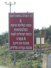
- Area A (full civil and security control by the Palestinian Authority): circa 3% of the West Bank, exclusive East-Jerusalem (first phase, 1995). In 2011: 18%. This area includes all Palestinian cities and their surrounding areas, with no Israeli settlements. Entry into this area is forbidden to all Israeli citizens. The Israel Defense Forces maintain no presence, but sometimes conducts raids to arrest suspected militants.
- Area B (Palestinian civil control and joint Israeli-Palestinian security control): circa 25% (first phase, 1995). In 2011: 21%. Includes areas of many Palestinian towns and villages and areas, with no Israeli settlements.
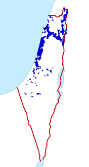
- Area C (full Israeli civil and security control, except over Palestinian civilians): circa 72% (first phase, 1995). In 2011: 61%. These areas include all Israeli settlements (cities, towns, and villages), nearby land, most roadways that connected the settlements (and which Israelis are now restricted to) as well as strategic areas described as "security zones." There were 1,000 Israeli settlers living in Area C in 1972. By 1993, their population had increased to 110,000. As of 2012 they number more than 300,000 – as against 150,000 Palestinians, the majority of whom are Bedouin and fellahin.
Governorates
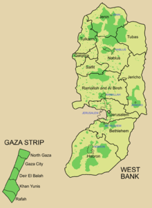
After the signing of the Oslo Accords, the Palestinian territories were divided 16 governorates under the jurisdiction of the Palestinian National Authority. Since 2007 there are two governments claiming to be the legitimate government of the Palestinian National Authority, one based in the West Bank and one based in the Gaza Strip.
History
In 1922, after the collapse of the Ottoman Empire that ruled Greater Syria for four centuries (1517–1917), the British Mandate for Palestine was established. Large-scale Jewish immigration from abroad, mainly from Eastern Europe took place during the British Mandate, though Jewish immigration started during the Ottoman period. The future of Palestine was hotly disputed between Arabs and Jews. In 1947, the total Jewish ownership of land in Palestine was 1,850,000 dunams or 1,850 square kilometers, which is 7.04% of the total land of Palestine. Public property or "crown lands", the bulk of which was in the Negev, belonging to the government of Palestine may have made up as much as 70% of the total land; with the Arabs, Christians and others owning the rest.
The 1947 United Nations Partition Plan proposed a division of Mandate Palestine between an Arab and a Jewish state, with Jerusalem and the surrounding area to be a corpus separatum under a special international regime. The regions allotted to the proposed Arab state included what became the Gaza Strip, and almost all of what became the West Bank, as well as other areas.
The Partition Plan was passed by the UN General Assembly on November 1947. The Partition Plan was accepted by the Jewish leadership, but rejected by the Arab leaders. The Arab League threatened to take military measures to prevent the partition of Palestine and to ensure the national rights of the Palestinian Arab population. One day before the expiration of the British Mandate for Palestine, on 14 May 1948, Israel declared its independence within the borders of the Jewish State set out in the Partition Plan. US President Harry Truman recognized the State of Israel de facto the following day. The Arab countries declared war on the newly formed State of Israel heralding the start of the 1948 Arab-Israeli War.
After the war, which Palestinians call the Nakba, the 1949 Armistice Agreements established the separation lines between the combatants, leaving Israel in control of some of the areas designated for the Arab state under the Partition Plan, Transjordan in control of the West Bank and East Jerusalem, Egypt in control of the Gaza Strip and Syria in control of the Himmah Area.
In 1950, Jordan annexed the West Bank and East Jerusalem. Only the United Kingdom formally recognized the annexation of the West Bank, de facto in the case of East Jerusalem. In the Gaza Strip the Arab League formed the All-Palestine Government, which operated under Egypt occupation.
Article 24 of the Palestinian National Covenant of 1964, which established the Palestine Liberation Organization, stated: "This Organization does not exercise any territorial sovereignty over the West Bank in the Hashemite Kingdom of Jordan, on the Gaza Strip or in the Himmah Area" (i.e. the areas of the former Mandate Palestine controlled by Jordan, Egypt and Syria, respectively).
Israel captured both territories in the 1967 Six-Day War, as well as other territory belonging to Egypt and Syria. Since then, these territories have been designated Israeli-occupied territories. Immediately after the war, on June 19, 1967, the Israeli government offered to return the Golan Heights to Syria, the Sinai to Egypt and most of the West Bank to Jordan in exchange for peace. At the Khartoum Summit in September, the Arab parties responded to this overture by declaring "no peace with Israel, no recognition of Israel and no negotiations with Israel."
UN Security Council Resolution 242 introduced the " Land for Peace" formula for normalizing relations between Israel and its neighbors. This formula was used when Israel returned the Sinai Peninsula to Egypt in 1979 in exchange for a peace treaty. While that treaty mentioned a "linkage" between Israeli-Egyptian peace and Palestinian autonomy, the formerly Egyptian-occupied territory in Gaza was excluded from the agreement, and remained under Israeli control.
The Oslo Accords of the early 1990s between the Palestine Liberation Organization and Israel led to the creation of the Palestinian Authority. This was an interim organization created to administer a limited form of Palestinian self-governance in the territories for a period of five years during which final-status negotiations would take place. The Palestinian Authority carried civil responsibility in some rural areas, as well as security responsibility in the major cities of the West Bank and the Gaza Strip. Although the five-year interim period expired in 1999, the final status agreement has yet to be concluded despite attempts such as the 2000 Camp David Summit, the Taba summit, and the unofficial Geneva Accords.

