

Tripoli
Background Information
This selection is made for schools by a children's charity read more. To compare sponsorship charities this is the best sponsorship link.
Coordinates: 32°54′8″N 13°11′9″E
| Tripoli طرابلس Trābles |
|||
|---|---|---|---|
 |
|||
|
|||
 |
|||
| Country | Libya | ||
| Sha'biyah | Tripoli Sha'biyah | ||
| Government | |||
| • Head of the People's Committee | Abdullatif Abdulrahman Aldaali | ||
| Area | |||
| • Total | 400 km2 (200 sq mi) | ||
| Elevation | 81 m (266 ft) | ||
| Population (2005) | |||
| • Total | 1,682,000 | ||
| • Density | 4,205/km2 (10,890/sq mi) | ||
| Time zone | EET ( UTC+2) | ||
| • Summer ( DST) | not observed ( UTC+2) | ||
Tripoli (Arabic: طرابلس Ṭarābulus pronunciation- also طرابلس الغرب Ṭarā-bu-lus al-Gharb Libyan vernacular: Ṭrābləs pronunciation; derived from the word for "three cities" in Greek: Τρίπολις Tripolis) is the largest and capital city of Libya.
Tripoli has a population of 1.69 million. The city is located in the northwest of the country on the edge of the desert, on a point of rocky land projecting into the Mediterranean Sea and forming a bay. Tripoli was founded in the 7th century BC by the Phoenicians, who named it Oea.
Tripoli is the largest city, the principal sea port, and the largest commercial and manufacturing centre in Libya. It is also the site of Al-Fateh University. Due to the city's long history, there are many sites of archaeological significance in Tripoli. The climate is typical Mediterranean, with hot, dry summers, cool winters and some modest rainfall.
"Tripoli" may also refer to the shabiyah (top-level administrative division in the current Libyan system), Tripoli District.
History
Early history
The city was founded in the 7th century BC, by the Phoenicians, who named it "Oea". They were probably attracted to the site by its fine natural harbour, flanked on the western shore by the small, easily defendable peninsula, on which they established their colony. The city then passed into the hands of the rulers of Cyrenaica (a Greek colony on the North African shore, east of Tripoli, halfway to Egypt). It was wrested away from the Greeks by the Carthaginians, like Tripoli, another Phoenician colony.
By the later half of the 2nd century BC it belonged to the Romans, who included it in their province of Africa, and gave it the name of Regio Syrtica. Around the beginning of the 3rd century AD, it became known as the Regio Tripolitana, meaning "region of the three cities", namely Oea (i.e. modern Tripoli), Sabratha and Leptis Magna. It was probably raised to the rank of a separate province by Septimius Severus, who was a native of Leptis Magna.
In spite of centuries of Roman habitation, the only visible Roman remains, apart from scattered columns and capitals (usually integrated in later buildings), is the Arch of Marcus Aurelius from the 2nd century AD. The fact that Tripoli has been continuously inhabited, unlike e.g. Sabratha and Leptis Magna, has meant that the inhabitants have either quarried material from older buildings (destroying them in the process), or built on top of them, burying them beneath the streets, where they remain largely unexcavated.
There is evidence to suggest that the Tripolitania region was in some economic decline during the 5th and 6th centuries, in part due to the political unrest spreading across the Mediterranean world in the wake of the collapse of the Roman empire, as well as pressure from the invading Vandals.
Like the rest of North Africa, it was conquered by the Muslims early in the 8th century. Following the conquest, Tripoli was ruled by dynasties based in Cairo, Egypt, first the Fatimids, and later the Mamluks.
1500s–1800s
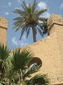
In 1510, it was taken by Don Pedro Navarro, Count of Oliveto for Spain, and, in 1523, it was assigned to the Knights of St. John, who had lately been expelled by the Ottoman Turks from their stronghold on the island of Rhodes. Finding themselves in very hostile territory, the Knights enhanced the city’s walls and other defences. Though built on top of a number of older buildings (possibly including a Roman public bath), much of the earliest defensive structures of the Tripoli castle (or "Assaraya al-Hamra", i.e. the "Red Castle") are attributed to the Knights of St John.
Having previously combated piracy from their base on Rhodes, the reason that the Knights were given charge of the city was to prevent it from relapsing into the nest of Barbary pirates as it had been prior to the Spanish occupation. The disruption the pirates caused to the Christian shipping lanes in the Mediterranean had been one of the main incentives for the Spanish conquest of the city.

The knights kept the city with some trouble until 1551, when they were compelled to surrender to the Ottoman Turks, led by Turgut Reis. Turgut was also buried in Tripoli after his death in 1565. His body was taken from Malta, where he had fallen during the Ottoman siege of the island, to a tomb in the mosque he had established close to his palace in Tripoli. The palace has since disappeared (supposedly it was situated between the so called “Ottoman prison” and the arch of Marcus Aurelius), but the mosque, along with his tomb, still stands, close to the Bab Al-Bahr gate.
After the capture by the Ottoman Turks, Tripoli once again became a base of operation for Barbary pirates. Effective Ottoman rule during this period (1551–1711) was often hampered by the local Janissary corps. Intended to function as enforcers of local administration, the captain of the Janissaries and his cronies were often the de facto rulers.
In 1711 Ahmed Karamanli, a Janissary officer of Turkish origin, killed the Ottoman governor, the " Pasha", and established himself as ruler of the Tripolitania region. By 1714 he had asserted a sort of semi-independence from the Ottoman Sultan, heralding in the Karamanli dynasty. The Pashas of Tripoli were expected to pay a regular tributary tax to the Sultan, but were in all other aspects rulers of an independent kingdom. This order of things continued under the rule of his descendants, accompanied by the brazen piracy and blackmailing until 1835, when the Ottoman Empire took advantage of an internal struggle and re-established its authority.
The Ottoman province (vilayet) of Tripoli (including the dependent sanjak of Cyrenaica) lay along the southern shore of the Mediterranean Sea between Tunisia in the west and Egypt in the east. Besides the city itself, the area included Cyrenaica (the Barca plateau), the chain of oases in the Aujila depression, Fezzan and the oases of Ghadames and Ghat, separated by sandy and stony wastelands.
The Barbary Wars

In the early part of the 19th century, the regency at Tripoli, owing to its piratical practices, was twice involved in war with the United States. In May 1801, the pasha demanded an increase in the tribute ($83,000) which the US government had been paying since 1796 for the protection of their commerce from piracy under the 1796 Treaty with Tripoli. The demand was refused, and a naval force was sent from the United States to blockade Tripoli.
The First Barbary War dragged on for four years. In 1803, Tripolitan fighters captured the US frigate Philadelphia and took its commander, Captain William Bainbridge, and the entire crew as prisoners. The Philadelphia was turned against the Americans and anchored in Tripoli Harbour as a gun battery. The following year, US Navy Lieutenant Stephen Decatur led a successful nighttime raid to retake and burn the ship. Decatur's men set fire to the Philadelphia and escaped.
The most colorful incident in the war was the expedition undertaken by William Eaton with the object of replacing the pasha with an elder brother living in exile, who had promised to accede to all the wishes of the United States. Eaton, at the head of a crew of 500 US Marines, Greek, Arab and Turkish Mercenaries, marched across the desert from Alexandria, Egypt and with the aid of American ships, succeeded in capturing Derna. Soon afterward, on June 3, 1805, peace was concluded. The pasha ended his demands and received $60,000 as ransom for the Philadelphia prisoners under the 1805 Treaty with Tripoli.
In 1815, in consequence of further outrages and due to the humiliation of the earlier defeat, Captains Bainbridge and Stephen Decatur, at the head of an American squadron, again visited Tripoli and forced the pasha to comply with the demands of the United States. See Second Barbary War.
Later history

In 1835, the Ottomans took advantage of a local civil war to reassert their direct authority. After that date, Tripoli was under the direct control of the Sublime Porte. Rebellions in 1842 and 1844 were unsuccessful. After the occupation of Tunisia by the French (1881), the Ottomans increased their garrison in Tripoli considerably.
Italy had long claimed that Tripoli fell within its zone of influence and that Italy had the right to preserve order within the state. Under the pretext of protecting its own citizens living in Tripoli from the Ottoman Government, it declared war against the Ottomans on September 29, 1911, and announced its intention of annexing Tripoli. On October 1, 1911, a naval battle was fought at Prevesa, Greece, and three Ottoman vessels were destroyed. By the Treaty of Lausanne, Italian sovereignty was acknowledged by the Ottomans, although the Caliph was permitted to exercise religious authority.
Tripoli was nominally controlled by Italy until 1943. Afterwards it was governed by British forces until independence in 1951.
On 15 April 1986 US Air Force and Navy planes bombed Tripoli and Benghazi. President Ronald Reagan justified the attacks by claiming Libya was responsible for terrorism directed at the USA, including the bombing of La Belle discothèque in West Berlin ten days before.
United Nations sanctions against Libya were lifted in 2003, which is expected to increase traffic through the Port of Tripoli and have a positive impact on the city's economy.
Law and government

The city of Tripoli and its surrounding suburbs all lie within the Tripoli sha'biyah (district). In accordance with Libya's Jamahiriya political system, Tripoli comprises Local People's Congresses where, in theory, the city's population discuss different matters and elect their own people's committee; At present there are 29 Local People's Congresses. In reality, the revolutionary committees severely limit the democratic process by closely supervising committee and congress elections at the branch and district levels of governments, Tripoli being no exception.
Tripoli is sometimes referred to as the de-facto capital of Libya. This is because none of the country's ministries are actually located in the capital. Even the National General People's Congress is held annually in the city of Surt and not the capital. As part of a radical decentralisation programme undertaken in September 1988, all General People's Committee secretariats ( ministries), except those responsible for foreign liaison ( foreign affairs) and information, were located away from Tripoli. According to diplomatic sources, the former Secretariat for Economy and Trade was moved to Benghazi; the Secretariat for Health to Kufra; and the remainder, excepting one, to Surt, Col. Gaddafi's birthplace. In early 1993 it was announced that the Secretariat for Foreign Liaison and International Co-operation was to be moved to Ras Lanouf.
Geography and climate


Tripoli lies at the western extremity of Libya close to the Tunisian border, on the continent of Africa. Over a thousand kilometers separate Tripoli from Libya's second largest city, Benghazi. Coastal oases alternate with sandy areas and lagoons along the shores of Tripolitania for more than 300 kilometers.
Until 2007, the " Sha'biyah" included the City, its suburbs and their immediate surroundings. In older administrative systems and throughout history, there existed a Province (" muhafazah"), State (" wilayah") or City-state with a much larger area (though not constant boundaries), which is sometimes mistakenly referred to as Tripoli but more appropriately should be called Tripolitania.
As a sha'biyah, Tripoli borders the following sha'biyat:
- Al Murgub – east
- Al Jabal al Gharbi – south
- Al Jfara – southwest
- Az Zawiyah – west
The dominant climatic influences in Tripoli, a coastal lowland city, are Mediterranean. The city enjoys warm summers and mild winters with an average July temperature of between 22 °C (72 °F) and 29 °C (84 °F). In December temperatures have reached as low as 1 °C (34 °F), but the average remains at between 9 °C (48 °F) and 18 °C (64 °F). The average annual rainfall is less than 400 millimetres (15.7 in), but can be very erratic.
For example, epic floods in 1945 left Tripoli under water for several days, but two years later an unprecedentedly severe drought caused the loss of thousands of head of cattle. Deficiency in rainfall is no doubt reflected in an absence of permanent rivers or streams in Tripoli as well as an absence throughout the entire country. The allocation of limited water is considered of sufficient importance to warrant the existence of the Secretariat of Dams and Water Resources, and damaging a source of water can be penalized by a heavy fine or imprisonment.
The Great Manmade River, a network of pipelines that transport water from the desert to the coastal cities, supplies Tripoli with its water. The grand scheme was initiated by Gaddafi in 1982 and has had a positive impact on the city's inhabitants.
Tripoli is dotted with public spaces, but few fit under the category of large city parks. The Green Square located near the waterfront is scattered with palm trees, the most abundant plant used for landscaping in the city. Tripoli zoo, located south of the city centre, is a large reserve of plants, trees and open green spaces and is the country's biggest zoo.
| Climate data for Tripoli | |||||||||||||
|---|---|---|---|---|---|---|---|---|---|---|---|---|---|
| Month | Jan | Feb | Mar | Apr | May | Jun | Jul | Aug | Sep | Oct | Nov | Dec | Year |
| Source: BBC Weather | |||||||||||||
Green square


Fountain


Medina
-
-

.
-

.
-


Winter


Economy


Tripoli is one of the main hubs of Libya's economy along with Misurata. It is the leading centre of banking, finance and communication in the country and is one of the leading commercial and manufacturing cities in Libya. Many of the country's largest corporations locate their headquarters home offices in Tripoli as well as the majority of international companies.
Major manufactured goods include processed food, textiles, construction materials, clothing and tobacco products. Since the lifting of sanctions against Libya in 1999 and again in 2003, Tripoli has seen a rise in foreign investment as well as an increase in tourism. Increased traffic has also been recorded in the city's port as well as Libya's main international airport, Tripoli International.
The city is home to the Tripoli International Fair, an international industrial, agricultural and commercial event located on Omar Muktar Street. One of the active members of the Global Association of the Exhibition Industry (UFI), located in the French capital Paris, the international fair is organised annually and takes place from the 2nd to the 12th of April. Participation averages around 30 countries as well as more than 2000 companies and organisations.
Since the rise in tourism and influx of foreign , there has been an increased demand for hotels in the city. To cater for these increased demands, the Corinthia Bab Africa Hotel located in the central business district was constructed in 2003 and is the largest hotel in Libya. Other high end hotels in Tripoli include the Al Waddan Intercontinental and the Tripoli Radisson Blu Hotel as well as others.
Companies with head offices in Tripoli include Afriqiyah Airways and Libyan Airlines.
Tourism

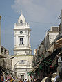
The city's old town is still unspoilt by mass-tourism, though it is increasingly being exposed to more and more visitors from abroad, following the lifting of the UN embargo in 2003. However, the walled medina retains much of its serene old-world ambience. The Assaraya al-Hamra (the Red Castle), a vast palace complex with numerous courtyards, dominates the city skyline and is located on the outskirts of the medina. There are some classical statues and fountains from the Ottoman period scattered around the castle.
The Gurgi and Karamanli mosques, with their intricate decorations and tilework, are examples of the artistic skills of local craftsmen. Just outside the Gurgi mosque is the Arch of Marcus Aurelius, the only surviving Roman monument in the city. More and more palaces (especially from the Karamanli period) are also being restored and opened to the public. The basic street plan of the medina was laid down in the Roman period when the walls were constructed as protection against attacks from the interior of Tripolitania, and are considered well planned, possibly better than modern street plans. In the 8th century a wall on the sea-facing side of the city was added.
Three gates provided access to the old town: Bab Zanata in the west, Bab Hawara in the southeast and Bab Al-Bahr in the north wall. The city walls are still standing and can be climbed for good views of the city. The Bazaar is also known for its traditional ware; fine jewellery and clothes can be found in the local markets. The Jamahiriya Museum, a fine modern facility located in the Red Castle, is Libya's national museum. It houses many artefacts from the country's Roman and Greek periods, including treasures from the World Heritage sites at Leptis Magna and Sabratha, as well as politically motivated displays such as the Volkswagen Beetle car driven by Gadaffi in the 1960s.
Colleges and universities
The largest university in Tripoli, Al Fateh University, is a public university providing free education to the city's inhabitants. Private universities and colleges have also begun to crop up in the last few years.
Universities in Tripoli include:
- Al Fateh University – The largest and most important university in Tripoli
- Al Fateh University for Medical Sciences – It includes the following faculties: Medicine, Pharmacy, Dentistry and nursing (which was previously a small institute).
- The Open University
- Tripoli University
- Informatics Tripoli
Sports

Soccer is the most popular sport in the Libyan capital. Tripoli is home to two of the most prominent soccer clubs in Libya, Al Ahly (Tripoli) and Al Ittihad.
The main sports clubs based in Tripoli:
- Al Wahda
The city also played host to the Italian Super Cup in 2002, a contest in which Juventus defeated Parma 2–1.
Sister cities
 Algiers, Algeria
 Beirut, Lebanon
 Belo Horizonte, Brazil (since 2003)
 Izmir, Turkey
 Madrid, Spain
 Sarajevo, Bosnia and Herzegovina (since 1976)
Transport
Tripoli is the interim destination of a railway from Sirt under construction in 2007.