
Grafika:Faroe islands map with island names.png
Z Wikipedii
Rozmiar podglądu: 450 × 600 pikseli
Obraz w wyższej rozdzielczości (600 × 800 pikseli, rozmiar pliku: 29 kB, typ MIME: image/png)
| | Plik Faroe islands map with island names.png [ edytuj opis ] umieszczony jest w Wikimedia Commons, repozytorium wolnych zasobów projektów Fundacji Wikimedia. Wyjaśnienie podanej poniżej licencji znajdziesz na stronie Opisy licencji grafiki. |
[edit] Summary
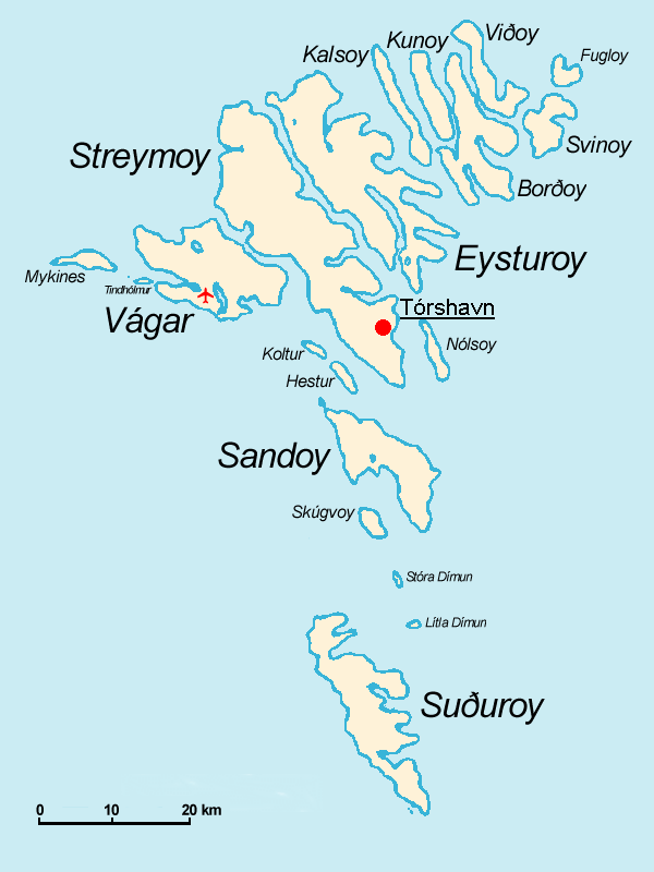
Español: Mapa de las Islas Feroe. Posición del aeropuerto marcado con el avión rojo.
- The Faroe Islands
- Graphics Arne List
- Description: This basic map shows the names of the 18 islands plus the islet Tindhólmur west of Vágar, which is not counted as one of the islands. Furthermore, on this map you see the Airport Vágar and the capital Tórshavn, the two international destinations, if you come via plane or ferry. Last but not least bears the sea no caption, for this map should be translated in different languages by yourself. The sea in the West is the North Atlantic Ocean, and in the East Norwegian Sea (which is a part of the Atlantic).

Historia pliku
Kliknij na datę/czas, aby zobaczyć, jak plik wyglądał w tym czasie.
| Data/czas | Wymiary | Użytkownik | Opis | |
|---|---|---|---|---|
| aktualny | 11:32, 18 lis 2004 | 600×800 (29 kB) | Arne List | (GFDL) |
Odnośniki do pliku
Następujące strony odwołują się do tego pliku:

