
Grafika:Greatrift.jpg
Z Wikipedii
Grafika w wyższej rozdzielczości jest niedostępna.
Greatrift.jpg (300 × 318 pikseli, rozmiar pliku: 28 kB, typ MIME: image/jpeg)
| | Plik Greatrift.jpg [ edytuj opis ] umieszczony jest w Wikimedia Commons, repozytorium wolnych zasobów projektów Fundacji Wikimedia. Wyjaśnienie podanej poniżej licencji znajdziesz na stronie Opisy licencji grafiki. |
| Description |
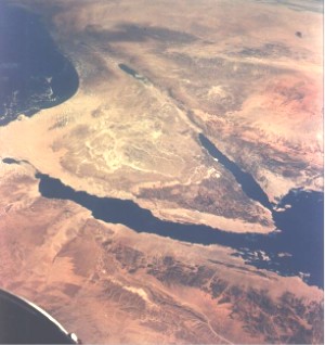
English: Near East area as seen from Gemini 11 spacecraft during its 26th revolution of the earth. The United Arab Republic (Egypt) is in foreground. Triangular-shaped area is the Sinai Penisula. Saudia Arabia is at upper right. The Mediterranean Sea is at upper left. The Gulf of Suez separates Egypt from the Sinai Peninsula. The Red Sea is at bottom right. The Gulf of Aqaba is body of water in right center of photography separating the Sinai Peninsula and the Arabian Peninsula. The Dead Sea, Sea of Galilee, Jordan and Israel are in top center of picture. Iraq is at top right edge of photograph.
Español: La región del Sinaí desde el espacio. Al oeste se sitúa el golfo de Suez y a la derecha el de Eilat
|
|---|---|
| Source |
Moved from the English Wikipedia, where it was uploaded by Pollinator
|
| Date |
1966-09-14 |
| Author |
NASA/JSC |
| Permission (Reusing this image) |
see below |
| This image or video was catalogued by one of the centers of the United States National Aeronautics and Space Administration (NASA) under Photo ID: S66-54893. This tag does not indicate the copyright status or the source of the attached work. A normal copyright tag and a source are still required. See Commons:Licensing for more information. |
|
|
This file is in the public domain because it was created by NASA. NASA copyright policy states that "NASA material is not protected by copyright unless noted". (NASA copyright policy page or JPL Image Use Policy).
Deutsch | English | Español | Français | Nederlands | Português | Русский | 中文(简体) | 中文(繁體) | +/- |
|
 |
Warnings:
|
Historia pliku
Kliknij na datę/czas, aby zobaczyć, jak plik wyglądał w tym czasie.
| Data/czas | Wymiary | Użytkownik | Opis | |
|---|---|---|---|---|
| aktualny | 14:29, 15 paź 2005 | 300×318 (28 kB) | Yuval Madar | (This image was taken from the English Wikipedia, where it was uploaded by Pollinator. Original description - :From NASA Photo taken during Gemini XI mission. Permission to use granted by NASA according to NASA Image guidelines: h) |
Odnośniki do pliku
Następujące strony odwołują się do tego pliku:

