
Grafika:Neckar river watershed.png
Z Wikipedii
Rozmiar podglądu: 484 × 600 pikseli
Obraz w wyższej rozdzielczości (514 × 637 pikseli, rozmiar pliku: 14 kB, typ MIME: image/png)
| | Plik Neckar river watershed.png [ edytuj opis ] umieszczony jest w Wikimedia Commons, repozytorium wolnych zasobów projektów Fundacji Wikimedia. Wyjaśnienie podanej poniżej licencji znajdziesz na stronie Opisy licencji grafiki. |
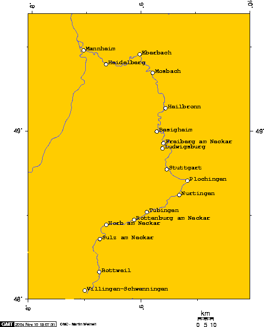
Watershed of the Neckar River
Source: Englis wikipedia (see interwiki)
The author (Geo Swan) declares this image GFDL. Uploaded 2004-11-09T03:41:50.

The author says:
I used this online map creation tool to create this map. In case it becomes necessary to modify this map these are the longitude and latitude I used to create this map. Geo Swan 04:07, 9 Nov 2004 (UTC)
- 8.4800,48.0553, Villingen-Schwenningen
- 8.6281,48.1667, Rottweil
- 8.6318,48.3624, Sulz am Neckar
- 8.6900,48.4465, Horb am Neckar
- 8.9377,48.4769, Rottenburg am Neckar
- 9.0521,48.5229, Tubingen
- 9.3426,48.6246, Nurtingen
- 9.4173,48.7098, Plochingen
- 9.2000,48.7772, Stuttgart
- 9.1934,48.9020, Ludwigsburg
- 9.2025,48.9324, Freiberg am Neckar
- 9.1421,49.0023, Besigheim
- 9.2221,49.1416, Heilbronn
- 9.1459,49.3520, Mosbach
- 8.9871,49.4624, Eberbach
- 8.6802,49.4019, Heidelberg
- 8.4757,49.4845, Mannheim
Historia pliku
Kliknij na datę/czas, aby zobaczyć, jak plik wyglądał w tym czasie.
| Data/czas | Wymiary | Użytkownik | Opis | |
|---|---|---|---|---|
| aktualny | 18:51, 13 lis 2004 | 514×637 (14 kB) | Mschlindwein | (Neckar Watershed) |
Odnośniki do pliku
Następujące strony odwołują się do tego pliku:

