
Grafika:Southern ocean gravity hg.png
Z Wikipedii
Rozmiar podglądu: 800 × 558 pikseli
Obraz w wyższej rozdzielczości (1 155 × 806 pikseli, rozmiar pliku: 1,18 MB, typ MIME: image/png)
| | Plik Southern ocean gravity hg.png [ edytuj opis ] umieszczony jest w Wikimedia Commons, repozytorium wolnych zasobów projektów Fundacji Wikimedia. Wyjaśnienie podanej poniżej licencji znajdziesz na stronie Opisy licencji grafiki. |
| Description |
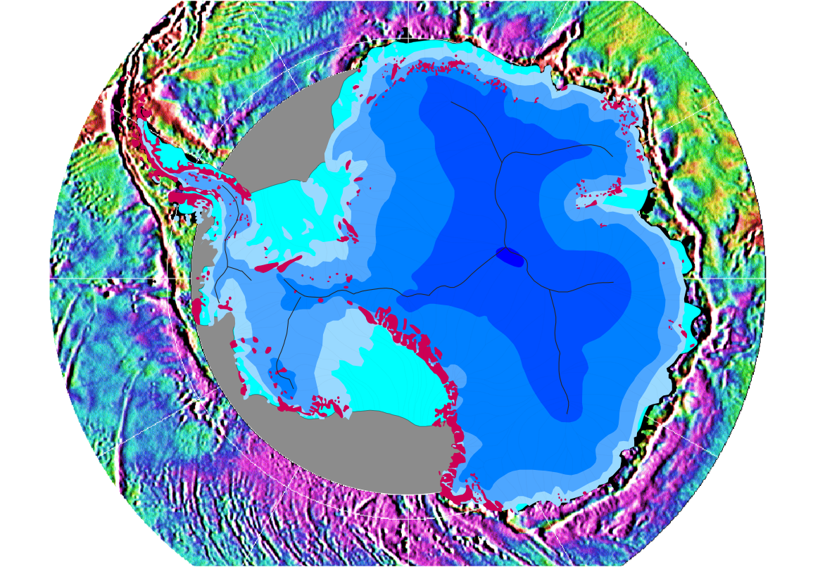
Gravity map of the Southern Ocean around the Antarctic continent This gravity field was computed from sea-surface height measurements collected by the US Navy GEOSAT altimeter between March, 1985, and January, 1990. The high density GEOSAT Geodetic Mission data that lie south of 30 deg. S were declassified by the Navy in May of 1992 and contribute most of the fine-scale gravity information. The Antarctic continent itself is shaded in blue depending on the thickness of the ice sheet (blue shades in steps of 1000 m); light blue is shelf ice; gray lines are the major ice devides; pink spots are parts of the continent which are not covered by ice; gray areas have no data. |
|---|---|
| Source |
Antarctic continent: own work; gravity field: NOAA/NGDC (Marks, McAdoo & Smith) |
| Date |
2006-08-08 |
| Author |
Hannes Grobe, AWI |
| Permission (Reusing this image) |
Own work and public domain of NOAA |
| Other versions | Gravity data are available from the National Oceanographic Data Center, NOAA (NODC Env. Bull. 93-1); the digital gravity data shown in this image are available from the National Geophysical Data Center on the Global Relief CD-ROM (NGDC Data Announcement 93-MGG-01). See the GIF image at NGDC. |
| This image is in the public domain because it contains materials that originally came from the U.S. National Oceanic and Atmospheric Administration, taken or made during the course of an employee's official duties. |
|
Historia pliku
Kliknij na datę/czas, aby zobaczyć, jak plik wyglądał w tym czasie.
| Data/czas | Wymiary | Użytkownik | Opis | |
|---|---|---|---|---|
| aktualny | 23:53, 12 sie 2006 | 1 155×806 (1,18 MB) | Hgrobe | ({{Information| |Description=Gravity map of the Southern Ocean around the Antarctic continent |Source=own work |Date=2006-08-08 |Author=~~~~ |Permission=Own work, share alike, attribution required (Creative Commons CC-BY-SA-2.5) |other_versions= }} {{self) |
Odnośniki do pliku
Następujące strony odwołują się do tego pliku:

