

File:Race and ethnicity 2010- Houston.png
Size of this preview: 480 × 480 pixels.
| |
This is a file from the Wikimedia Commons. Information from its description page there is shown below.
Commons is a freely licensed media file repository. You can help. |
Summary
| Description |
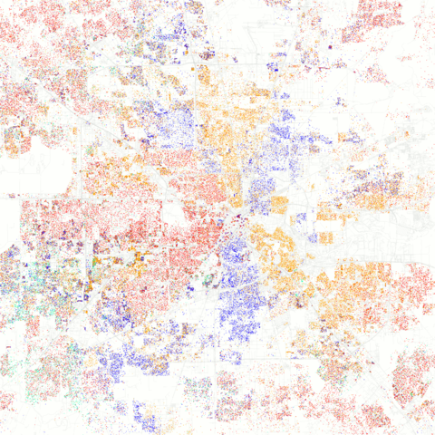
English: Maps of racial and ethnic divisions in US cities, inspired by Bill Rankin's map of Chicago, updated for Census 2010.
Red is White, Blue is Black, Green is Asian, Orange is Hispanic, Yellow is Other, and each dot is 25 residents. Data from Census 2010. Base map © OpenStreetMap, CC-BY-SA |
| Date | 25 March 2011, 21:55 |
| Source | Race and ethnicity 2010: Houston |
| Author | Eric Fischer |
|
Camera location |
|
This and other images at their locations on: Google Maps - Google Earth - OpenStreetMap | ( Info) |
|---|
Licensing
| This file is licensed under the Creative Commons Attribution-Share Alike 2.0 Generic license. | ||
|
| This image was originally posted to Flickr by Eric Fischer at http://flickr.com/photos/24431382@N03/5560487046. It was reviewed on 18 September 2011 by the FlickreviewR robot and was confirmed to be licensed under the terms of the cc-by-sa-2.0. |
File usage
The following pages on Schools Wikipedia link to this image (list may be incomplete):
Find out more
SOS Childrens Villages has brought Wikipedia to the classroom. SOS Childrens Villages is famous for the love and shelter it brings to lone children, but we also support families in the areas around our Children's Villages, helping those who need us the most. Sponsoring a child is a great way to help children who need your support.