

Houston
Background Information
This wikipedia selection has been chosen by volunteers helping SOS Children from Wikipedia for this Wikipedia Selection for schools. Before you decide about sponsoring a child, why not learn about different sponsorship charities first?
| Houston | |||
|---|---|---|---|
| — City — | |||
| City of Houston | |||
 |
|||
|
|||
| Nickname(s): Space City (official), more. . . | |||
 |
|||
 Houston
|
|||
| Coordinates: 29°45′46″N 95°22′59″W Coordinates: 29°45′46″N 95°22′59″W | |||
| Country | United States of America | ||
| State | Texas | ||
| Counties | Harris, Fort Bend, and Montgomery | ||
| Incorporated | June 5, 1837 | ||
| Government | |||
| • Type | Mayor–council | ||
| • Mayor | Annise Parker | ||
| Area | |||
| • City | 627.8 sq mi (1,625.2 km2) | ||
| • Land | 599.59 sq mi (1,552.9 km2) | ||
| • Water | 27.9 sq mi (72.3 km2) | ||
| Elevation | 43 ft (13 m) | ||
| Population (2010 US Census) | |||
| • City | 2,100,263( 4th U.S.) | ||
| • Density | 3,623/sq mi (1,505/km2) | ||
| • Urban | 4,944,332 ( 7th U.S.) | ||
| • Metro | 6,086,538 ( 5th U.S.) | ||
| • Demonym | Houstonian | ||
| Time zone | CST ( UTC-6) | ||
| • Summer ( DST) | CDT ( UTC-5) | ||
| Area code(s) | 713, 281, 832 | ||
| FIPS code | 48-35000 | ||
| GNIS feature ID | 1380948 | ||
| Website | houstontx.gov | ||

Houston (pron.: / ˈ h juː s t ən /) is the fourth most populous city in the United States of America, and the most populous city in the state of Texas. According to the 2010 U.S. Census, the city had a population of 2.1 million people within a land area of 599.6 square miles (1,553 km2). Houston is the seat of Harris County and the economic centre of Houston–The Woodlands-Sugar Land, the fifth-largest metropolitan area in the U.S. with over 6 million people.
Houston was founded in 1836 on land near the banks of Buffalo Bayou, now known as Allen's Landing. and incorporated as a city on June 5, 1837. The city was named after former General Sam Houston, who was president of the Republic of Texas and had commanded and won at the Battle of San Jacinto 25 miles (40 km) east of where the city was established. The burgeoning port and railroad industry, combined with oil discovery in 1901, has induced continual surges in the city's population. In the mid-twentieth century, Houston became the home of the Texas Medical Centre—the world's largest concentration of healthcare and research institutions—and NASA's Johnson Space Centre, where the Mission Control Centre is located.
Rated as a global city, Houston's economy has a broad industrial base in energy, manufacturing, aeronautics, and transportation. It is also leading in health care sectors and building oilfield equipment; only New York City is home to more Fortune 500 headquarters. The Port of Houston ranks first in the United States in international waterborne tonnage handled and second in total cargo tonnage handled. In 2012, the city was ranked No.1 for paycheck worth by Forbes. The city has a population from various ethnic and religious backgrounds and a large and growing international community. It is home to many cultural institutions and exhibits, which attract more than 7 million visitors a year to the Museum District. Houston has an active visual and performing arts scene in the Theatre District and offers year-round resident companies in all major performing arts.
History

In August 1836, two real estate entrepreneurs— Augustus Chapman Allen and John Kirby Allen—from New York, purchased 6,642 acres (26.88 km2) of land along Buffalo Bayou with the intent of founding a city. The Allen brothers decided to name the city after Sam Houston, the popular general at the Battle of San Jacinto, who was elected President of Texas in September 1836.
Houston was granted incorporation on June 5, 1837, with James S. Holman becoming its first mayor. In the same year, Houston became the county seat of Harrisburg County (now Harris County) and the temporary capital of the Republic of Texas. In 1840, the community established a chamber of commerce in part to promote shipping and waterborne business at the newly created port on Buffalo Bayou.

By 1860, Houston had emerged as a commercial and railroad hub for the export of cotton. Railroad spurs from the Texas inland converged in Houston, where they met rail lines to the ports of Galveston and Beaumont. During the American Civil War, Houston served as a headquarters for General John Bankhead Magruder, who used the city as an organization point for the Battle of Galveston. After the Civil War, Houston businessmen initiated efforts to widen the city's extensive system of bayous so the city could accept more commerce between downtown and the nearby port of Galveston. By 1890, Houston was the railroad centre of Texas.

In 1900, after Galveston was struck by a devastating hurricane, efforts to make Houston into a viable deepwater port were accelerated. The following year, oil discovered at the Spindletop oil field near Beaumont prompted the development of the Texas petroleum industry. In 1902, President Theodore Roosevelt approved a $1 million improvement project for the Houston Ship Channel. By 1910 the city's population had reached 78,800, almost doubling from a decade before. African-Americans formed a large part of the city's population, numbering 23,929 people, or nearly one-third of the residents.
President Woodrow Wilson opened the deepwater Port of Houston in 1914, seven years after digging began. By 1930, Houston had become Texas's most populous city and Harris the most populous county. In 1940, the Census Bureau reported Houston's population as 77.5% white and 22.4% black.

When World War II started, tonnage levels at the port decreased and shipping activities were suspended; however, the war did provide economic benefits for the city. Petrochemical refineries and manufacturing plants were constructed along the ship channel because of the demand for petroleum and synthetic rubber products during the war. Ellington Field, initially built during World War I, was revitalized as an advanced training centre for bombardiers and navigators. The Brown Shipbuilding Company was founded in 1942 to build ships for the U.S. Navy during World War II. The M.D. Anderson Foundation formed the Texas Medical Centre in 1945. After the war, Houston's economy reverted to being primarily port-driven. In 1948, several unincorporated areas were annexed into the city limits, which more than doubled the city's size, and Houston proper began to spread across the region.
In 1950, the availability of air conditioning provided impetus for many companies to relocate to Houston resulting in an economic boom and producing a key shift in the city's economy toward the energy sector.


The increased production of the local shipbuilding industry during World War II spurred Houston's growth, as did the establishment in 1961 of NASA's "Manned Spacecraft Centre" (renamed the Lyndon B. Johnson Space Centre in 1973), which created the city's aerospace industry. The Astrodome, nicknamed the " Eighth Wonder of the World", opened in 1965 as the world's first indoor domed sports stadium.
During the late 1970s, Houston experienced a population boom as people from Rust Belt states moved to Texas in large numbers. The new residents came for the numerous employment opportunities in the petroleum industry, created as a result of the Arab Oil Embargo.
The population boom ended abruptly in the mid-1980s, as oil prices fell precipitously. The space industry also suffered in 1986 after the Space Shuttle Challenger disintegrated shortly after launch. The late 1980s saw a recession adversely affecting the city's economy.
Since the 1990s, as a result of the recession, Houston has made efforts to diversify its economy by focusing on aerospace and health care/biotechnology and by reducing its dependence on the petroleum industry. In 1997, Houstonians elected Lee P. Brown as the city's first African American mayor.
In June 2001, Tropical Storm Allison dumped up to 40 inches (1,000 mm) of rain on parts of Houston, causing the worst flooding in the city's history; the storm cost billions of dollars in damage and killed 20 people in Texas. By December of that same year, Houston-based energy company Enron collapsed into the third-largest ever U.S. bankruptcy during an investigation surrounding fabricated partnerships that were allegedly used to hide debt and inflate profits.
In August 2005, Houston became a shelter to more than 150,000 people from New Orleans who evacuated from Hurricane Katrina. One month later, approximately 2.5 million Houston area residents evacuated when Hurricane Rita approached the Gulf Coast, leaving little damage to the Houston area. This was the largest urban evacuation in the history of the United States.
Geography

According to the United States Census Bureau, the city has a total area of 656.3 square miles (1,700 km2); this comprises 634.0 square miles (1,642 km2) of land and 22.3 square miles (58 km2) of water. Most of Houston is located on the gulf coastal plain, and its vegetation is classified as temperate grassland and forest. Much of the city was built on forested land, marshes, swamp, or prairie, which are all still visible in surrounding areas. Flatness of the local terrain, when combined with urban sprawl, has made flooding a recurring problem for the city. Downtown stands about 50 feet (15 m) above sea level, and the highest point in far northwest Houston is about 125 feet (38 m) in elevation. The city once relied on groundwater for its needs, but land subsidence forced the city to turn to ground-level water sources such as Lake Houston, Lake Conroe and Lake Livingston. The city owns surface water rights for 1.20 billion gallons of water a day in addition to 150 million gallons a day worth of groundwater.
Houston has four major bayous passing through the city. Buffalo Bayou runs through downtown and the Houston Ship Channel, and has three tributaries: White Oak Bayou, which runs through the Houston Heights community northwest of Downtown and then towards Downtown; Braes Bayou, which runs along the Texas Medical Centre; and Sims Bayou, which runs through the south of Houston and downtown Houston. The ship channel continues past Galveston and then into the Gulf of Mexico.
Geology
Underpinning Houston's land surface are unconsolidated clays, clay shales, and poorly cemented sands up to several miles deep. The region's geology developed from river deposits formed from the erosion of the Rocky Mountains. These sediments consist of a series of sands and clays deposited on decaying organic marine matter, that over time, transformed into oil and natural gas. Beneath the layers of sediment is a water-deposited layer of halite, a rock salt. The porous layers were compressed over time and forced upward. As it pushed upward, the salt dragged surrounding sediments into salt dome formations, often trapping oil and gas that seeped from the surrounding porous sands. The thick, rich, sometimes black, surface soil is suitable for rice farming in suburban outskirts where the city continues to grow.
The Houston area has over 150 active faults (estimated to be 300 active faults) with an aggregate length of up to 310 miles (500 km), including the Long Point–Eureka Heights fault system which runs through the centre of the city. There have been no significant historically recorded earthquakes in Houston, but researchers do not discount the possibility of such quakes having occurred in the deeper past, nor occurring in the future. Land in some areas southeast of Houston is sinking because water has been pumped out of the ground for many years. It may be associated with slip along the faults; however, the slippage is slow and not considered an earthquake, where stationary faults must slip suddenly enough to create seismic waves. These faults also tend to move at a smooth rate in what is termed " fault creep", which further reduces the risk of an earthquake.
Climate

Houston's climate is classified as humid subtropical (Cfa in Köppen climate classification system). While not necessarily part of " Tornado Alley" like much of the rest of Texas, spring supercell thunderstorms do sometimes bring tornadoes to the area. Prevailing winds are from the south and southeast during most of the year, bringing heat from the western deserts and moisture from the Gulf of Mexico.
During the summer months, it is common for the temperature to reach over 90 °F (32 °C), with an average of 99 days per year above 90 °F (32 °C). However, the humidity causes a heat index higher than the actual temperature. Summer mornings average over 90 percent relative humidity and approximately 60 percent in the afternoon. Winds are often light in the summer and offer little relief, except near the immediate coast. To cope with the heat, people use air conditioning in nearly every vehicle and building in the city; in 1980 Houston was described as the "most air-conditioned place on earth". Scattered afternoon showers and thunderstorms are common in the summer. The hottest temperature ever recorded in Houston is 109 °F (43 °C), which was reached both on September 4, 2000 and August 28, 2011.
Winters in Houston are mild. The average high in January, the coldest month, is 63 °F (17 °C), while the average low is 43 °F (6 °C). Snowfall is very rare. Recent snow events in Houston include a storm on December 24, 2004 when one inch (2.5 cm) fell and more recent snowfalls on December 10, 2008. This was the earliest snowfall ever recorded in Houston. In addition, it set another milestone marking the first time in recorded history that snowfall has occurred in two consecutive years, and was the third accumulating snowfall occurring in the decade of 2000–2010. The coldest temperature ever recorded in Houston was 5 °F (−15 °C) on January 23, 1940. Houston receives a high amount of rainfall annually, averaging about 50 inches (1,270 mm) a year. These rains tend to cause floods over portions of the city.
Houston has excessive ozone levels and is routinely ranked among the most ozone-polluted cities in the United States. Ground-level ozone, or smog, is Houston's predominant air pollution problem, with the American Lung Association rating the metropolitan area's ozone level as the 8th worst in the United States in 2011. The industries located along the ship channel are a major cause of the city's air pollution. In the past, Houston's air quality has been compared to that of Los Angeles.
| Climate data for Houston ( Intercontinental Airport), 1981–2010 normals, | |||||||||||||
|---|---|---|---|---|---|---|---|---|---|---|---|---|---|
| Month | Jan | Feb | Mar | Apr | May | Jun | Jul | Aug | Sep | Oct | Nov | Dec | Year |
| Record high °F (°C) | 87 (31) |
91 (33) |
96 (36) |
95 (35) |
99 (37) |
105 (41) |
105 (41) |
109 (43) |
109 (43) |
99 (37) |
89 (32) |
85 (29) |
109 (43) |
| Average high °F (°C) | 62.9 (17.2) |
66.3 (19.1) |
73.0 (22.8) |
79.6 (26.4) |
86.3 (30.2) |
91.4 (33) |
93.7 (34.3) |
94.5 (34.7) |
89.7 (32.1) |
82.0 (27.8) |
72.5 (22.5) |
64.3 (17.9) |
79.7 (26.5) |
| Average low °F (°C) | 43.2 (6.2) |
46.5 (8.1) |
52.5 (11.4) |
59.4 (15.2) |
67.6 (19.8) |
73.5 (23.1) |
75.1 (23.9) |
74.8 (23.8) |
69.8 (21) |
60.9 (16.1) |
52.1 (11.2) |
44.6 (7) |
60.0 (15.6) |
| Record low °F (°C) | 5 (−15) |
6 (−14) |
21 (−6) |
31 (−1) |
44 (7) |
52 (11) |
62 (17) |
54 (12) |
45 (7) |
29 (−2) |
19 (−7) |
7 (−14) |
5 (−15) |
| Precipitation inches (mm) | 3.38 (85.9) |
3.20 (81.3) |
3.41 (86.6) |
3.31 (84.1) |
5.09 (129.3) |
5.93 (150.6) |
3.79 (96.3) |
3.76 (95.5) |
4.12 (104.6) |
5.70 (144.8) |
4.34 (110.2) |
3.74 (95) |
49.76 (1,263.9) |
| Avg. precipitation days (≥ 0.01 in) | 9.6 | 9.2 | 8.8 | 6.8 | 8.0 | 10.6 | 9.1 | 8.3 | 8.0 | 7.9 | 8.2 | 9.5 | 104.1 |
| Percent possible sunshine | 45 | 50 | 54 | 58 | 62 | 68 | 70 | 68 | 66 | 64 | 52 | 51 | 59 |
| Source #1: NOAA (Average percent sunshine through 2009) | |||||||||||||
| Source #2: ThreadEx (records, 1889–last full calendar year) | |||||||||||||
Cityscape
Houston was incorporated in 1837 under the ward system of representation. The ward designation is the progenitor of the eleven current-day geographically-oriented Houston City Council districts. Locations in Houston are generally classified as either being inside or outside the Interstate 610 Loop. The inside encompasses the central business district and many residential neighborhoods that predate World War II. More recently, high-density residential areas have been developed within the loop. The city's outlying areas, suburbs and enclaves are located outside of the loop. Beltway 8 encircles the city another 5 miles (8.0 km) farther out.
Though Houston is the largest city in the United States without formal zoning regulations, it has developed similarly to other Sun Belt cities because the city's land use regulations and legal covenants have played a similar role. Regulations include mandatory lot size for single-family houses and requirements that parking be available to tenants and customers. Such restrictions have had mixed results. Though some have blamed the city's low density, urban sprawl, and lack of pedestrian-friendliness on these policies, the city's land use has also been credited with having significant affordable housing, sparing Houston the worst effects of the 2008 real estate crisis. The city issued 42,697 building permits in 2008 and was ranked first in the list of healthiest housing markets for 2009.
Voters rejected efforts to have separate residential and commercial land-use districts in 1948, 1962, and 1993. Consequently, rather than a single central business district as the centre of the city's employment, multiple districts have grown throughout the city in addition to downtown which include Uptown, Texas Medical Centre, Midtown, Greenway Plaza, Memorial City, Energy Corridor, Westchase, and Greenspoint.


Government and politics

The city of Houston has a strong mayoral form of municipal government. Houston is a home rule city and all municipal elections in the state of Texas are nonpartisan. The City's elected officials are the mayor, city controller and 16 members of the city council. The current mayor of Houston is Annise Parker, a Democrat elected on a nonpartisan ballot whose second term in office will expire at the end of 2013. Houston's mayor serves as the city's chief administrator, executive officer, and official representative, and is responsible for the general management of the city and for seeing that all laws and ordinances are enforced.
The original city council line-up of 14 members (nine district-based and five at-large positions) was based on a U.S. Justice Department mandate which took effect in 1979. At-large council members represent the entire city. Under the city charter, once the population in the city limits exceeded 2.1 million residents, two additional districts were to be added. The City of Houston's official 2010 census count was 600 shy of the required number; however, as the city was expected to grow beyond 2.1 million shortly thereafter, the two additional districts were added and the positions filled during the August 2011 elections. The districts are labeled A through K while the at-large positions are numbered 1 through 5.
The city controller is elected independently of the mayor and council. The controller's duties are to certify available funds prior to committing such funds and processing disbursements. The city's fiscal year begins on July 1 and ends on June 30. Ronald Green is the city controller, serving his first term as of January 2010.
As the result of a 1991 referendum in Houston, a mayor is elected for a two-year term, and can be elected to as many as three consecutive terms. The term limits were spearheaded by conservative political activist Clymer Wright. The city controller and city council members are also subject to the same two-year, three-term limitations.
Houston is considered to be a politically divided city whose balance of power often sways between Republicans and Democrats. Much of the city's wealthier areas vote Republican, while the city's middle class, working class, and minority areas vote Democratic. According to the 2005 Houston Area Survey, 68 percent of non-Hispanic whites in Harris County are declared or favor Republicans while 89 percent of non-Hispanic blacks in the area are declared or favor Democrats. About 62 percent Hispanics (of any race) in the area are declared or favour Democrats. The city has often been known to be the most politically diverse city in Texas, a state known for being generally conservative. As a result the city is often a contested area in statewide elections. In 2009, Houston became the first US city with a population over 1 million to elect a gay mayor, by electing Annise Parker.
Economy
| Top publicly traded companies in Houston for 2011 with Texas and U.S. ranks |
|||||
| Texas | Corporation | US | |||
| 2 | ConocoPhillips | 4 | |||
| 5 | Marathon Oil | 29 | |||
| 7 | Sysco | 67 | |||
| 8 | Enterprise Products Partners | 80 | |||
| 9 | Plains All American Pipeline | 99 | |||
| 14 | Halliburton | 144 | |||
| 17 | Baker Hughes | 170 | |||
| 19 | Waste Management, Inc | 196 | |||
| 20 | National Oilwell Varco | 202 | |||
| 23 | Apache Corporation | 206 | |||
| 25 | KBR | 242 | |||
| 29 | CenterPoint Energy | 279 | |||
| 32 | Kinder Morgan | 294 | |||
| 34 | Enbridge Energy Partners | 309 | |||
| 35 | Calpine | 349 | |||
| 38 | Cameron International | 375 | |||
| 39 | EOG Resources | 377 | |||
| 41 | Frontier Oil | 389 | |||
| 44 | Group 1 Automotive | 413 | |||
| 45 | Targa Resources | 416 | |||
| 46 | Spectra Energy | 441 | |||
| 48 | El Paso Energy | 481 | |||
| Notes | |||||
| Revenues for year ending 2010 | |||||
| Energy and oil (20 companies) | |||||
| Source: Fortune | |||||

Houston is recognized worldwide for its energy industry—particularly for oil and natural gas—as well as for biomedical research and aeronautics. Renewable energy sources—wind and solar—are also growing economic bases in Houston. The ship channel is also a large part of Houston's economic base. Because of these strengths, Houston is designated as a global city by the Globalization and World Cities Study Group and Network and by global management consulting firm A.T. Kearney.
The Houston area is a leading centre for building oilfield equipment. Much of Houston's success as a petrochemical complex is due to its busy man-made ship channel, the Port of Houston. The port ranks first in the United States in international commerce, and is the tenth-largest port in the world. Unlike most places, high oil and gasoline prices are beneficial for Houston's economy as many of its residents are employed in the energy industry.
The Houston–Sugar Land–Baytown MSA's gross domestic product (GDP) in 2010 was $385 billion, larger than Austria's, Argentina's or South Africa's GDP. Only 21 countries other than the United States have a gross domestic product exceeding Houston's regional gross area product. Mining, which in Houston consists almost entirely of exploration and production of oil and gas, accounts for 26.3% of Houston's GAP, up sharply in response to high energy prices and a decreased worldwide surplus of oil production capacity; followed by engineering services, health services, and manufacturing.

The University of Houston System's annual impact on the Houston-area's economy equates to that of a major corporation: $1.1 billion in new funds attracted annually to the Houston area, $3.13 billion in total economic benefit, and 24,000 local jobs generated. This is in addition to the 12,500 new graduates the UH System produces every year who enter the workforce in Houston and throughout Texas. These degree-holders tend to stay in Houston. After five years, 80.5 percent of graduates are still living and working in the region.
In 2006, the Houston metropolitan area ranked first in Texas and third in the U.S. within the Category of "Best Places for Business and Careers" by Forbes magazine. Foreign governments have established 92 consular offices in metropolitan Houston, the third highest in the nation. Forty foreign governments maintain trade and commercial offices here and 23 active foreign chambers of commerce and trade associations. Twenty-five foreign banks representing 13 nations operate in Houston, providing financial assistance to the international community.
In 2008, Houston received top ranking on Kiplinger's Personal Finance Best Cities of 2008 list which ranks cities on their local economy, employment opportunities, reasonable living costs and quality of life. The city ranked fourth for highest increase in the local technological innovation over the preceding 15 years, according to Forbes magazine. In the same year, the city ranked second on the annual Fortune 500 list of company headquarters, ranked first for Forbes Best Cities for College Graduates, and ranked first on Forbes list of Best Cities to Buy a Home. In 2010, the city was rated the best city for shopping, according to Forbes.
Demographics
| Historical populations | |||
|---|---|---|---|
| Census | Pop. | %± | |
| 1850 | 2,396 |
|
|
| 1860 | 4,845 | 102.2% | |
| 1870 | 9,332 | 92.6% | |
| 1880 | 16,513 | 77.0% | |
| 1890 | 27,557 | 66.9% | |
| 1900 | 44,633 | 62.0% | |
| 1910 | 78,800 | 76.6% | |
| 1920 | 138,276 | 75.5% | |
| 1930 | 292,352 | 111.4% | |
| 1940 | 384,514 | 31.5% | |
| 1950 | 596,163 | 55.0% | |
| 1960 | 938,219 | 57.4% | |
| 1970 | 1,232,802 | 31.4% | |
| 1980 | 1,595,138 | 29.4% | |
| 1990 | 1,630,553 | 2.2% | |
| 2000 | 1,953,631 | 19.8% | |
| 2010 | 2,100,263 | 7.5% | |
| Est. 2012 | 2,151,475 | 2.4% | |
|
2011 estimate |
|||

Houston is a multicultural city, in part because of its many academic institutions and strong industries as well as being a major port city. Over 90 languages are spoken in the city. The city has among the youngest populations in the nation, partly due to an influx of immigrants into Texas. An estimated 400,000 undocumented immigrants reside in the Houston area.
According to the 2010 Census, whites made up 51% of Houston's population; 26% of the total population were non-Hispanic whites. Blacks or African Americans made up 24% of Houston's population. American Indians made up 0.7% of Houston's population. Asians made up 6% of Houston's population (1.7% Vietnamese, 1.3% Chinese, 1.3% Indian, 0.9% Pakistani, 0.4% Filipino, 0.3% Korean, 0.1% Japanese), while Pacific Islanders made up 0.1%. Individuals from some other race made up 15.2% of the city's population, of which 0.2% were non-Hispanic. Individuals from two or more races made up 3.3% of the city's population. People of Hispanic origin, regardless of race, made up 44% of Houston's population
As of the 2000 Census, there were 1,953,631 people and the population density was 3,371.7 people per square mile (1,301.8/km²). The racial makeup of the city was 49.3% White, 25.3% African American, 5.3% Asian, 0.4% American Indian, 0.1% Pacific Islander, 16.5% from some other race, and 3.1% from two or more races. In addition, Hispanics made up 37.4% of Houston's population while non-Hispanic whites made up 30.8%, down from 62.4% in 1970.
The median income for a household in the city was $37,000, and the median income for a family was $40,000. Males had a median income of $32,000 versus $27,000 for females. The per capita income for the city was $20,000. Nineteen percent of the population and 16 percent of families were below the poverty line. Out of the total population, 26% of those under the age of 18 and 14% of those 65 and older were living below the poverty line.
Culture

Houston is a diverse city with a large and growing international community. The metropolitan area is home to an estimated 1.1 million (21.4 percent) residents who were born outside the United States, with nearly two-thirds of the area's foreign-born population from south of the United States–Mexico border. Additionally, more than one in five foreign-born residents are from Asia. The city is home to the nation's third-largest concentration of consular offices, representing 86 countries.
Many annual events celebrate the diverse cultures of Houston. The largest and longest running is the annual Houston Livestock Show and Rodeo, held over 20 days from late February to early March, which happens to be the largest annual livestock show and rodeo anywhere in the world. Another large celebration is the annual night-time Houston Pride Parade, held at the end of June. Other annual events include the Houston Greek Festival, Art Car Parade, the Houston Auto Show, the Houston International Festival, and the Bayou City Art Festival, which is considered to be one of the top five art festivals in the United States.
Houston received the official nickname of "Space City" in 1967 because it is the location of NASA's Lyndon B. Johnson Space Centre. Other nicknames often used by locals include " Bayou City," "Magnolia City," "New Houston," a tribute to the cultural contributions of New Orleans natives who left their city during the Hurricane Katrina catastrophe, and "H-Town."


Arts and theatre


The Houston Theater District, located downtown, is home to nine major performing arts organizations and six performance halls. It is the second-largest concentration of theatre seats in a downtown area in the United States. Houston is one of few United States cities with permanent, professional, resident companies in all major performing arts disciplines: opera ( Houston Grand Opera), ballet ( Houston Ballet), music ( Houston Symphony Orchestra), and theatre ( The Alley Theatre). Houston is also home to folk artists, art groups and various small progressive arts organizations. Houston attracts many touring Broadway acts, concerts, shows, and exhibitions for a variety of interests. Facilities in the Theatre District include the Jones Hall—home of the Houston Symphony Orchestra and Society for the Performing Arts—and the Hobby Centre for the Performing Arts.
The Museum District's cultural institutions and exhibits attract more than 7 million visitors a year. Notable facilities include The Museum of Fine Arts, Houston Museum of Natural Science, the Contemporary Arts Museum Houston, the Station Museum of Contemporary Art, Holocaust Museum Houston, and the Houston Zoo. Located near the Museum District are The Menil Collection, Rothko Chapel, and the Byzantine Fresco Chapel Museum.
Bayou Bend is a 14-acre (5.7 ha) facility of the Museum of Fine Arts that houses one of America's best collections of decorative art, paintings and furniture. Bayou Bend is the former home of Houston philanthropist Ima Hogg.
The National Museum of Funeral History is located in Houston near the George Bush Intercontinental Airport. The museum houses the original Popemobile used by Pope John Paul II in the 1980s along with numerous hearses, embalming displays and information on famous funerals.
Venues across Houston regularly host local and touring rock, blues, country, dubstep, and Tejano musical acts. While Houston has never been widely known for its music scene, Houston hip-hop has become a significant, independent music scene that is influential nationwide.
Tourism and recreation


The Theater District is a 17-block area in the centre of downtown Houston that is home to the Bayou Place entertainment complex, restaurants, movies, plazas, and parks. Bayou Place is a large multilevel building containing full-service restaurants, bars, live music, billiards, and Sundance Cinema. The Houston Verizon Wireless Theatre stages live concerts, stage plays, and stand-up comedy. Space Center Houston is the official visitors' centre of NASA's Lyndon B. Johnson Space Center. The Space Centre has many interactive exhibits including moon rocks, a shuttle simulator, and presentations about the history of NASA's manned space flight program. Other tourist attractions include the Galleria (Texas's largest shopping mall located in the Uptown District), Old Market Square, the Downtown Aquarium, and Sam Houston Race Park.
Of worthy mention are Houston's current Chinatown and the Mahatma Gandhi District. Both areas offer a picturesque view of Houston's multicultural makeup. Restaurants, bakeries, traditional-clothing boutiques and specialty shops can be found in both areas.


Houston is home to 337 parks including Hermann Park, Terry Hershey Park, Lake Houston Park, Memorial Park, Tranquility Park, Sesquicentennial Park, Discovery Green, and Sam Houston Park. Within Hermann Park are the Houston Zoo and the Houston Museum of Natural Science. Sam Houston Park contains restored and reconstructed homes which were originally built between 1823 and 1905. There is a proposal to open the city's first botanic garden at Herman Brown Park.
Of the 10 most populous U.S. cities, Houston has the most total area of parks and green space, 56,405 acres (228 km2) The city also has over 200 additional green spaces—totaling over 19,600 acres (79 km2) that are managed by the city—including the Houston Arboretum and Nature Centre. The Lee and Joe Jamail Skatepark is a public skatepark owned and operated by the city of Houston, and is one of the largest skateparks in Texas consisting of 30,000 (2,800 m2) square foot in-ground facility. The Gerald D. Hines Waterwall Park—located in the Uptown District of the city—serves as a popular tourist attraction, weddings, and various celebrations. A 2011 study by Walk Score ranked Houston the 23rd most walkable of the 50 largest cities in the United States. SplashTown Waterpark Houston is a water park located north of Houston.
The Bayport Cruise Terminal on the Houston Ship Channel will become port of call for both Princess Cruises and Norwegian Cruise Line in 2013-2014.
Education

Seventeen school districts exist within the city of Houston. The Houston Independent School District (HISD) is the seventh-largest school district in the United States. HISD has 112 campuses that serve as magnet or vanguard schools—specializing in such disciplines as health professions, visual and performing arts, and the sciences. There are also many charter schools that are run separately from school districts. In addition, some public school districts also have their own charter schools.
The Houston area encompasses more than 300 private schools, many of which are accredited by Texas Private School Accreditation Commission recognized agencies. The Houston Area Independent Schools offer education from a variety of different religious as well as secular viewpoints. The Houston area Catholic schools are operated by the Archdiocese of Galveston-Houston.
Colleges and universities

Four separate and distinct state universities are located in Houston. The University of Houston is a nationally recognized Tier One research university, and is the flagship institution of the University of Houston System. The third-largest university in Texas, the University of Houston has nearly 40,000 students on its 667 acre campus in southeast Houston. The University of Houston–Clear Lake and the University of Houston–Downtown are stand-alone universities; they are not branch campuses of the University of Houston. Located in the historic community of Third Ward is Texas Southern University, one of the largest historically black colleges and universities in the United States.
Several private institutions of higher learning—ranging from liberal arts colleges to Rice University, the nationally recognized research university—are located within the city. Rice, with a total enrollment of slightly more than 6,000 students, is widely recognized as one of the top twenty universities in the nation, and it has a number of distinguished graduate programs and research institutes such as the James A. Baker Institute for Public Policy. The university's undergraduates are among the most select in the nation.
Three community college districts exist with campuses in and around Houston. The Houston Community College System serves most of Houston. The northwestern through northeastern parts of the city are served by various campuses of the Lone Star College System, while the southeastern portion of Houston is served by San Jacinto College. The Houston Community College and Lone Star College systems are within the 10 largest institutions of higher learning in the United States.
Healthcare


Houston is the seat of the internationally renowned Texas Medical Center, which contains the world's largest concentration of research and healthcare institutions. All 49 member institutions of the Texas Medical Center are non-profit organizations. They provide patient and preventive care, research, education, and local, national, and international community well-being. Employing more than 73,600 people, institutions at the medical centre include 13 hospitals and two specialty institutions, two medical schools, four nursing schools, and schools of dentistry, public health, pharmacy, and virtually all health-related careers. It is where one of the first—and still the largest—air emergency service, Life Flight, was created, and a very successful inter-institutional transplant program was developed. More heart surgeries are performed at the Texas Medical Centre than anywhere else in the world.
Some of the academic and research health institutions at the centre include MD Anderson Cancer Centre, Baylor College of Medicine, UT Health Science Centre, Memorial Hermann Hospital, The Methodist Hospital, Texas Children's Hospital, and University of Houston College of Pharmacy.
The Baylor College of Medicine has annually been considered within the top ten medical schools in the nation; likewise, the MD Anderson Cancer Centre has consistently ranked as one of the top two U.S. hospitals specializing in cancer care by U.S. News & World Report since 1990. The Menninger Clinic, a renowned psychiatric treatment centre, is affiliated with Baylor College of Medicine and The Methodist Hospital System. With hospital locations nationwide and headquarters in Houston, the Triumph Healthcare hospital system is the third largest long term acute care provider nationally.
Transportation
Highways

The predominant form of transportation in Houston is the automobile with 71.7 percent of residents driving alone to work This is facilitated through Houston's freeway system, comprising 739.3 miles (1,189.8 km) of freeways and expressways in a ten-county metropolitan area. However, the Texas Transportation Institute's annual Urban Mobility Report found that Houston had the fourth-worst congestion in the country with commuters spending an average of 58 hours in traffic in 2009.
Houston's highway system has a hub-and-spoke freeway structure serviced by multiple loops. The innermost loop is Interstate 610, which encircles downtown, the medical centre, and many core neighborhoods with around a 10-mile (16 km) diameter. Beltway 8 and its freeway core, the Sam Houston Tollway, form the middle loop at a diameter of roughly 25 miles (40 km). A proposed highway project, State Highway 99 (Grand Parkway), would form a third loop outside of Houston. As of 2010, only two out of eleven segments of State Highway 99 have been completed. Houston is located along the route of the proposed Interstate 69 NAFTA superhighway that would link Canada, the U.S. industrial Midwest, Texas, and Mexico. Other spoke freeways either planned or under construction include the Fort Bend Parkway, Hardy Toll Road, Crosby Freeway, and the future Alvin Freeway.
Houston's freeway system is monitored by Houston TranStar—a partnership of four government agencies that are responsible for providing transportation and emergency management services to the region.

Transit systems
The Metropolitan Transit Authority of Harris County (METRO) provides public transportation in the form of buses, light rail, and lift vans. METRO's various forms of public transportation still do not connect many of the suburbs to the greater city.
METRO began light rail service on January 1, 2004 with the inaugural track ("Red Line") running about 8 miles (13 km) from the University of Houston–Downtown (UHD), which traverses through the Texas Medical Centre and terminates at Reliant Park. METRO is currently in the design phase of a 10-year expansion plan that will add five more lines to the existing system.
Amtrak, the national rail passenger system, provides service to Houston via the Sunset Limited (Los Angeles–New Orleans), which stops at a train station on the north side of the downtown area. The station saw 14,891 boardings and alightings in fiscal year 2008.
Cycling
Houston has the largest number of bike commuters in Texas with over 160 miles of dedicated bikeways. The city is currently in the process of expanding its on and off street bikeway network. A new Bicycle sharing system known as Houston B-Cycle currently operates 3 different stations in the downtown area.
Airports

Houston is served by three airports, two of which are commercial that served 52 million passengers in 2007 and managed by the Houston Airport System. The Federal Aviation Administration and the state of Texas selected the "Houston Airport System as Airport of the Year" for 2005, largely because of its multi-year, $3.1 billion airport improvement program for both major airports in Houston.
The primary city airport is George Bush Intercontinental Airport (IAH), the sixth-busiest in the United States for total passengers, and fourteenth-busiest worldwide. Bush Intercontinental currently ranks third in the United States for non-stop domestic and international service with 182 destinations. In 2006, the United States Department of Transportation named George Bush Intercontinental Airport the fastest-growing of the top ten airports in the United States. The Houston Air Route Traffic Control Centre stands on the George Bush Intercontinental Airport grounds.
Houston was the headquarters of Continental Airlines until its 2010 merger with United Airlines with headquarters in Chicago; regulatory approval for the merger was granted in October of that year. Bush Intercontinental became United Airline's largest airline hub. The airline retained a significant operational presence in Houston while offering more than 700 daily departures from the city. In early 2007, Bush Intercontinental Airport was named a model "port of entry" for international travelers by U.S. Customs and Border Protection.
The second-largest commercial airport is William P. Hobby Airport (named Houston International Airport until 1967) which operates primarily small to medium-haul domestic flights. Houston's aviation history is showcased in the 1940 Air Terminal Museum located in the old terminal building on the west side of the airport. Hobby Airport has been recognized with two awards for being one of the top five performing airports in the world and for customer service by Airports Council International.
Houston's third municipal airport is Ellington Airport (a former U.S. Air Force base) used by military, government, NASA, and general aviation sectors.
Architecture


Houston has the third tallest skyline in North America and one of the top 10 in the world. A seven-mile (11 km) system of tunnels and skywalks link downtown buildings containing shops and restaurants, enabling pedestrians to avoid summer heat and rain while walking between buildings.
In the 1960s, Downtown Houston consisted of a collection of mid-rise office structures. Downtown was on the threshold of an energy industry led boom in 1970. A succession of skyscrapers were built throughout the 1970s—many by real estate developer Gerald D. Hines—culminating with Houston's tallest skyscraper, the 75-floor, 1,002-foot (305 m)-tall JPMorgan Chase Tower (formerly the Texas Commerce Tower), completed in 1982. It is the tallest structure in Texas, 10th tallest building in the United States and the 30th tallest skyscraper in the world, based on height to roof. In 1983, the 71-floor, 992-foot (302 m)-tall Wells Fargo Plaza (formerly Allied Bank Plaza) was completed, becoming the second-tallest building in Houston and Texas. Based on height to roof, it is the 13th tallest in the United States and the 36th tallest in the world. As of 2007, downtown Houston had over 43 million square feet (4,000,000 m²) of office space.
Centered on Post Oak Boulevard and Westheimer Road, the Uptown District boomed during the 1970s and early 1980s when a collection of mid-rise office buildings, hotels, and retail developments appeared along Interstate 610 west. Uptown became one of the most prominent instances of an edge city. The tallest building in Uptown is the 64-floor, 901-foot (275 m)-tall, Philip Johnson and John Burgee designed landmark Williams Tower (known as the Transco Tower until 1999). At the time of construction, it was believed to the be the world's tallest skyscraper outside of a central business district. The Uptown District is also home to buildings designed by noted architects I. M. Pei, César Pelli, and Philip Johnson. In the late 1990s and early 2000s decade, there was a mini-boom of mid-rise and high-rise residential tower construction, with several over 30 stories tall. In 2002, Uptown had more than 23 million square feet (2,100,000 m²) of office space with 16 million square feet (1,500,000 m²) of Class A office space.
-

The Niels Esperson Building stood as the tallest building in Houston from 1927 to 1929.
-
The JP Morgan Chase Tower is the tallest building in Texas and the tallest 5-sided building in the world.
-

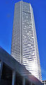
The Williams Tower in the Uptown District is the tallest building in the United States outside of a central business district.
-

The Bank of America Centre is an example of postmodern architecture construction designed by award winning architect Philip Johnson.
-

JPMorgan Chase Tower in Houston, Texas is the tallest composite building in the world


Sports


Houston has sports teams for every major professional league, except the National Hockey League. The city currently hosts three of the four major sports in the United States: The Houston Astros is an MLB expansion team formed in 1962 (as the Colt .45s until 1965), who made one World Series appearance ( 2005), the Houston Rockets, who was formed in 1967 in San Diego and relocated in 1971 (and have won 2 NBA Championships), and the Houston Texans of the NFL.
Minute Maid Park (home of the Astros) and Toyota Centre (home of the Rockets and Aeros), are located in Downtown. Houston has the NFL's first retractable-roof stadium, Reliant Stadium (home of the Texans). Minute Maid Park is also a retractable-roof stadium. The Toyota Centre also has the largest screen for an indoor arena in the world built to coincide with the arena's hosting of the 2013 NBA All-Star Game. BBVA Compass Stadium is a soccer-specific stadium for the Dynamo, located in East Downtown ( EaDo). In addition, Reliant Astrodome was the first indoor stadium in the world, built in 1965. Other sports facilities include Hofheinz Pavilion (Houston Cougars basketball), Rice Stadium ( Rice Owls football), and Reliant Arena. A new football stadium is currently under construction for the Houston Cougars football team, and is scheduled to open by August 2014.
Houston has hosted several major sports events: The 1968 MLB All-Star Game, the 1989, 2006 and 2013 NBA All-Star Game, Super Bowl VIII and Super Bowl XXXVIII, as well as hosting the 2005 World Series and 1981, 1986, 1994 and 1995 NBA Finals, winning the latter two.
Houston was home to the now defunct WNBA Comets from 1997 to 2008. The Comets won 4 WNBA Championships (all consecutive) which is still the most championships of any sports team in Houston, and the biggest title streak in Texas. The AFL/NFL Oilers called Houston home from 1960 to 1997 when the team moved to Tennessee and became the Titans.
The city has hosted several major professional and college sporting events, including the annual Shell Houston Open golf tournament. Houston hosts the annual NCAA College Baseball Minute Maid Classic every February and NCAA football's Texas Bowl in December.
The Shell and Pennzoil Grand Prix of Houston is an annual auto race on the IndyCar Series circuit. The race is held on a 1.7-mile temporary street circuit in Reliant Park. The next event will be held in October, 2013 sponsored by Royal Dutch Shell and using a tweaked version of the 2006-2007 course. The event has a 5-year race contract through 2017 with IndyCar and Shell, using its Pennzoil brand of motor oil, is signed for 4-years as the event's title sponsor.
Crime

Houston's murder rate ranked 46th of U.S. cities with a population over 250,000 in 2005 (per capita rate of 16.3 murders per 100,000 population). In 2010, the city's murder rate (per capita rate of 11.8 murders per 100,000 population) was ranked fifth among U.S. cities with a population of over 750,000 (behind New York City, Chicago, Detroit, Philadelphia) according to the FBI.
Murders fell by 37 percent from January to June 2011, compared with the same period in 2010. Houston's total crime rate including violent and nonviolent crimes decreased by 11 percent.
Houston is a significant hub for trafficking of cocaine, marijuana, heroin, MDMA, and methamphetamine due to its size and proximity to major illegal drug exporting nations.
In the early 1970s, Houston, Pasadena and several coastal towns were the site of the Houston Mass Murders, which at the time were the deadliest case of serial killing in American history.