

Google Maps
Did you know...
SOS Children have produced a selection of wikipedia articles for schools since 2005. A good way to help other children is by sponsoring a child
 Screenshot of Google Maps. |
|
| URL | maps.google.com |
|---|---|
| Commercial? | Yes |
| Type of site | Web mapping |
| Registration | Optional, included with a Google Account |
| Available language(s) | Multilingual |
| Owner | |
| Created by | |
| Launched | February 8, 2005 |
| Current status | Active |
Google Maps (formerly Google Local) is a web mapping service application and technology provided by Google, that powers many map-based services, including the Google Maps website, Google Ride Finder, Google Transit, and maps embedded on third-party websites via the Google Maps API. It offers street maps, a route planner for traveling by foot, car, bike (beta), or with public transportation and a locator for urban businesses in numerous countries around the world. Google Maps satellite images are not updated in real time, but rather they are several months or years old.
Google Maps uses a close variant of the Mercator projection, so it cannot show areas around the poles. A related product is Google Earth, a stand-alone program which offers more globe-viewing features, including showing polar areas.
Satellite view
Google Maps provides high-resolution aerial or satellite images for most urban areas all over the world. Most of the world's current satellite imagery is over 5 years old and updated infrequently, resulting in not showing the newer features and updates that have been made to various infrastructures. Various governments have complained about the potential for terrorists to use the satellite images in planning attacks. Google has blurred some areas for security (mostly in the United States), including the U.S. Naval Observatory area (where the official residence of the Vice President is located), and previously the United States Capitol and the White House. Other well-known government installations, including Area 51 in the Nevada desert, are visible.
Not all areas on satellite images are covered in the same resolution; less populated areas usually get less detail. With the introduction of an easily pannable and searchable mapping and satellite imagery tool, Google's mapping engine prompted a surge of interest in satellite imagery. Sites were established to feature satellite images of interesting natural and man-made landmarks, including such novelties as "large type" writing visible in the imagery, as well as famous stadiums and unique geological formations. Although Google uses the word satellite, most of the high-resolution imagery of cities is aerial photography taken from aircraft flying at 800–1500 feet rather than from satellites; while most other imagery is in fact from satellites.
Directions

Google Maps provides a route planner under "Get Directions". Up to four modes of transportation are available depending on the area: driving, public transit (see the Google Transit section below), walking, and bicycling. In some areas, cross-border routes are available, though others are limited to routes within a given country or region. Driving directions are covered as follows:
- Most countries of mainland Eurasia and Africa are covered contiguously, including the United Kingdom, Ireland, the Canary Islands, Malta and Sri Lanka. No directions are available for North and South Korea, and South Sudan; while Cyprus, Hong Kong, Israel (including parts of the West Bank), Jordan, Lebanon, and Macau have directions available without connection to other states.
- All countries of mainland North and Central America are covered contiguously.
- All countries of mainland South America are covered. Argentina, Bolivia, Brazil, Chile, Ecuador, Paraguay, Peru and Uruguay are treated contiguously, whereas Colombia, French Guiana, Guyana, Suriname and Venezuela are not connected to other states.
- All inhabited countries and territories in the Caribbean are covered, except for Trinidad and Tobago, though in general there are no connections between islands.
- Additionally, American Samoa, Australia, the Azores, Brunei, Cape Verde, The Comoros, The Cook Islands, the Faroe Islands, The Federated States of Micronesia, Fiji, French Polynesia, Guam, Hawaii, Iceland, Japan, Madagascar, the Maldives, Mauritius, Mayotte, New Caledonia, New Zealand, Niue, Palau, the Philippines, Réunion, São Tomé and Príncipe, the Seychelles, Samoa, Taiwan, Timor-Leste, Tonga, Vanuatu, Wallis and Futuna are covered as stand-alone regions, as are Nuuk in Greenland, parts of Indonesia (Bali, Borneo, Java, Lombok, Madura, Sulawesi and Sumatra), Sabah and Sarawak in Malaysia, Saipan in the Northern Mariana Islands, parts of Papua New Guinea, parts of Solomon Islands and Socotra in Yemen.
In addition, only directions with public transit are provided in South Korea.
Implementation
Like many other Google web applications, Google Maps uses JavaScript extensively. As the user drags the map, the grid squares are downloaded from the server and inserted into the page. When a user searches for a business, the results are downloaded in the background for insertion into the side panel and map; the page is not reloaded. Locations are drawn dynamically by positioning a red pin (composed of several partially transparent PNGs) on top of the map images. A hidden IFrame with form submission is used because it preserves browser history. The site also uses JSON for data transfer rather than XML, for performance reasons. These techniques both fall under the broad Ajax umbrella. The result is termed a slippy map and is implemented elsewhere in projects like OpenLayers.
In October 2011, Google announced MapsGL, a WebGL version of Maps with better renderings and smoother transitions.
Extensibility and customization
As Google Maps is coded almost entirely in JavaScript and XML, some end users have reverse-engineered the tool and produced client-side scripts and server-side hooks which allowed a user or website to introduce expanded or customized features into the Google Maps interface.
Using the core engine and the map/satellite images hosted by Google, such tools can introduce custom location icons, location coordinates and metadata, and even custom map image sources into the Google Maps interface. The script-insertion tool Greasemonkey provides a large number of client-side scripts to customize Google Maps data.
Combinations with photo sharing websites, such as Flickr, are used to create "memory maps". Using copies of the Keyhole satellite photos, users have taken advantage of image annotation features to provide personal histories and information regarding particular points of the area.
Google Maps API
After the success of reverse-engineered mashups such as chicagocrime.org and housingmaps.com, Google launched the Google Maps API in June 2005 to allow developers to integrate Google Maps into their websites. It is a free service, and currently does not contain ads, but Google states in their terms of use that they reserve the right to display ads in the future.
By using the Google Maps API, it is possible to embed Google Maps site into an external website, on to which site specific data can be overlaid. Although initially only a JavaScript API, the Maps API was expanded to include an API for Adobe Flash applications (but this has been deprecated), a service for retrieving static map images, and web services for performing geocoding, generating driving directions, and obtaining elevation profiles. Over 350,000 web sites use the Google Maps API, making it the most heavily used web application development API.
The Google Maps API is free for commercial use, provided that the site on which it is being used is publicly accessible and does not charge for access, and is not generating more than 25 000 map accesses a day. Sites that do not meet these requirements can purchase the Google Maps API for Business.
The success of the Google Maps API has spawned a number of competing alternatives, including the Yahoo! Maps API, Bing Maps Platform, MapQuest Development Platform, and OpenLayers.
In September 2011, Google announced it would discontinue a number of its products, including Google Maps API for Flash.
Google Maps for Mobile
In October 2005, Google introduced a Java application called Google Maps for Mobile, intended to run on any Java-based phone or mobile device. Many of the web-based site's features are provided in the application.
On November 28, 2007, Google Maps for Mobile 2.0 was released. Its location service can work with or without a GPS receiver. The "my location" feature uses the GPS / Assisted GPS location of the mobile device, if available, supplemented by determining the nearest wireless networks and cell sites. The software looks up the location of the cell site using a database of known wireless networks and sites. By triangulating the different signal strengths from different cell transmitters and then using their location property (retrieved from the online cell site database), My Location determines the user's current location. Wireless network location method is calculated by discovering the nearby WiFi hotspots and using their location property (retrieved from the online WiFi database, in the same way as the cell site database) to further discover the user's location. The order in which these take precedence is:
- GPS-based services
- WLAN-, WiFi-based services
- Cell transmitter-based services
The software plots the streets in blue that are available with a yellow icon and a green circle around the estimated range of the cell site based on the transmitter's rated power (among other variables). The estimate is refined using the strength of the cell phone signal to estimate how close to the cell site the mobile device is.
As of December 15, 2008, this service was available for the following platforms:
- Android
- iOS
- PlayStation Vita system software
- Windows Mobile
- Symbian OS
- BlackBerry OS
- Palm OS
- Palm webOS
On November 4, 2009, Google Maps Navigation was released in conjunction with Google Android OS 2.0 Eclair on the Motorola Droid, adding voice commands, traffic reports, and street view support. The initial release was limited to the United States. The service was launched in the UK on 20 April 2010 and in large parts of continental Europe on June 9, 2010 (including Austria, Belgium, Canada, Denmark, France, Germany, Italy, the Netherlands, Portugal, Spain, and Switzerland).
In March 2011 Google Vice President of Location Service, Marissa Mayer said that Google provided map services to 150 million users.
It provided voice guidance and live traffic information in the Indian cities of Bengaluru, Mumbai, New Delhi, Chennai, Pune and Hyderabad from September 5, 2012.
In June 2012, Apple announced that they would replace Google Maps with their own maps service from iOS 6. The application software and maps that replaced Google Maps came under fierce criticism for several problems and errors. However, on December 13, 2012, Google announced the availability of Google Maps in the Apple App Store, starting with the iPhone version. Just hours after the Google Maps iOS app was released, it became the top free app in the App Store. While Google maps as an app no longer enjoys the tight integration into the iOS as it had as a system service, the new version offers some features said to be easier to use and more intuitive than even the Android service.
It was announced on December 6, 2012 that Google Maps would make its way to the Wii U, Nintendo's new gaming system. Accessibility to Google Maps on the Wii U would come via a downloadable app.
Google Maps Android 2.0
Cell phones are being increasingly used for navigation assistance. Google Maps Navigation for Android 2.0 is free.
Features provided in the application:
- Search in plain English
- Search by voice
- Traffic view
- Search along route
- Satellite view
- Street View
- Car dock mode
Use
Maps and related information are not included in the installed Google Maps for Android file; an Internet connection is required, as for iPhone's Google Maps application. An automatic map caching feature temporarily stores recently viewed areas, reducing the amount of data to be downloaded. There is also a 'Download Map Area' feature in the Labs section of Google Maps which enables the user to download the basic road map and landmark data for an area of 10 square miles (26 km2) around any point; but even after a map of an area is downloaded, a data connection is still needed to "see satellite view and 3D buildings, search for Places and get directions.". The user can download limited areas several times to cover the total area desired. Google suggests that users can make use of this feature to download the map of a foreign city before traveling to visit it, to avoid the need for expensive international roaming data downloading.
Offline version
As of version 6.9 Google Maps offers offline access to downloaded maps of certain countries, a feature only offered in Labs of previous versions. 150 countries are available offline. For example one country that is not available offline is Colombia.
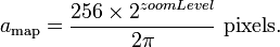
Google Maps parameters
In Google Maps, URL parameters are sometimes data-driven in their limits and the user interface presented by the web may or may not reflect those limits. In particular, the zoom level (denoted by the z parameter) supported varies. In less populated regions, the supported zoom levels might stop at around 18. In earlier versions of the API, specifying these higher values might result in no image being displayed. In Western cities, the supported zoom level generally stops at about 20. In some isolated cases, the data supports up to 23 or greater, as in these elephants or this view of people at a well in Chad, Africa. Different versions of the API and web interfaces may or may not fully support these higher levels.
As of October 2010, the Google map viewer updates its zoom bar to allow the user to zoom all the way when centered over areas that support higher zoom levels.
History
Acquisition
Google Maps first started as a C++ program designed by two Danish brothers Lars and Jens Rasmussen at the Sydney-based company Where 2 Technologies. It was first designed to be separately downloaded by users, but the company later pitched the idea for a purely Web-based product to Google management, changing the method of distribution. In October 2004 the company was acquired by Google Inc where it transformed into the web application Google Maps.
2005
The application was first announced on the Google Blog on February 8, 2005, and was located at Google. It originally only supported users of Internet Explorer and Mozilla web browsers, but support for Opera and Safari was added on February 25, 2005, but currently Opera is removed from the system requirements list. It was in beta for six months before becoming part of Google Local on October 6, 2005.
In April 2005, Google created Google Ride Finder using Google Maps. In June 2005, Google released the Google Maps API. In July 2005, Google began Google Maps and Google Local services for Japan, including road maps. On July 22, 2005, Google released "Hybrid View". Together with this change, the satellite image data was converted from plate carrée to Mercator projection, which makes for a less distorted image in the temperate climes latitudes. In July 2005, in honour of the thirty-sixth anniversary of the Apollo Moon landing, Google Moon was launched. In September 2005, in the aftermath of Hurricane Katrina, Google Maps quickly updated its satellite imagery of New Orleans to allow users to view the extent of the flooding in various parts of that city. (Oddly, in March 2007, imagery showing hurricane damage was replaced with images from before the storm; this replacement was not made on Google Earth, which still uses post-Katrina imagery).
2006
From January 2006, Google Maps featured road maps for the United States, Puerto Rico, Canada, the United Kingdom, Japan, and certain cities in the Republic of Ireland. Coverage of the area around Turin was added in time for the 2006 Winter Olympics. On January 23, 2006, Google Maps was updated to use the same satellite image database as Google Earth. On March 12, 2006, Google Mars was launched, which features a draggable map and satellite imagery of the planet Mars. In April 2006, Google Local was merged into the main Google Maps site. On April 3, 2006, version 2 of the Maps API was released. On June 11, 2006, Google added geocoding capabilities to the API, satisfying the most developer-requested feature for this service. On June 14, 2006, Google Maps for Enterprise was officially launched. As a commercial service, it features intranet and advertisement-free implementations. Also in June, textured 3D building models were added into google earth. In July 2006 Google started including Google Maps business listings in the form of Local OneBoxes in the main Google search results. On December 9 Google integrates the PlusBox in the main search results. On December 19 Google added a feature that lets you add multiple destinations to your driving directions. Beginning in February 2007, buildings and subway stops are displayed in Google Maps "map view" for parts of New York City, Washington, D.C., London, San Francisco, and some other cities.
2007
On January 29, 2007 Local Universal results were upgraded and more data included in the main Google results page. On February 28, 2007, Google Traffic info was officially launched to automatically include real-time traffic flow conditions to the maps of 30 major cities of the United States. On March 8, 2007, the Local Business Center was upgraded. On May 16, 2007 Google rolled out Universal search results, including more Map information on the main Google results page. On May 18, 2007 Google added neighbourhood search capabilities. On May 29, 2007, Google driving directions support was added to the Google Maps API. On May 29, 2007, Street View was added, giving a ground-level 360-degree view of streets in some major cities in United States. On June 19, 2007, reviews were allowed to be added directly to businesses on Google Maps. On June 28, 2007, draggable driving directions were introduced. On July 31, 2007, support for the hCard microformat was announced. Unfortunately, the implementation is broken. On August 21, 2007, Google announced a simple way to embed Google Maps into other websites. On September 13, 2007, 54 new countries were added to Google Maps in Latin America and Asia. On October 3, 2007, Google Transit was integrated into Google Maps making public transportation routing possible on Google Maps. On October 27, 2007, Google Maps started mapping the geoweb and showing the results in Google Maps. On October 27, 2007, Google Maps added a searchable interface for coupons in the business listings. On November 27, 2007, "Terrain" view showing basic topographic features was added. The button for "Hybrid" view was removed, and replaced with a "Show labels" checkbox under the "Satellite" button to switch between "Hybrid" and "Satellite" views.
2008
On January 22, 2008, Google expanded the Local Onebox from 3 business listings to 10. On February 20, 2008, Google Maps allowed searches to be refined by User Rating & neighborhoods. On March 18, 2008, Google allowed end users to edit business listings and add new places. On March 19, 2008, Google added unlimited category options in the Local Business Centre. On April 2, 2008, Google added contour lines to the Terrain view. In April 2008, a button to view recent Saved Locations was added to the right of the search field. In May 2008, a "More" button was added alongside the "Map", "Satellite", and "Terrain" buttons, permitting access to geographically related photos on Panoramio and articles on Wikipedia. On May 15, 2008, Google Maps was ported to Flash and ActionScript 3 as a foundation for richer internet applications. On July 15, 2008, walking directions were added. On August 4, 2008, Street View launched in Japan and Australia. On August 5, 2008, the user interface was redesigned. On August 29, 2008, Google signed a deal under which GeoEye would supply them with imagery from a satellite, and introduced the Map Maker tool, which allows any user to improve the map data seen by all. On September 9, 2008, a reverse business lookup feature was added. On September 23, 2008, information for the New York City Metropolitan Transit Authority was added. On October 7, 2008, GeoEye-1 took its first image, a bird's-eye view of Kutztown University in Pennsylvania. On October 26, 2008, reverse geocoding was added to the Maps API. On November 11, 2008, Street View in Spain, Italy, and France was introduced. On November 23, 2008, AIR support for the Maps API for Flash was added. On November 25, 2008, a new user interface for Street View was introduced. On November 27, 2008, maps, local business information, and local trends for China were introduced. On December 9, 2008, 2x Street View coverage was introduced.
2009
On Mar 19, 2009 Street View was launched in the United Kingdom and the Netherlands. In May, 2009, a new Google Maps logo was introduced. In early October 2009, Google replaced Tele Atlas as their primary supplier of geospatial data in the U.S. version of Maps and use their own data. In October 2009, the railroads were redone, featuring a slightly new look and updated, removing older lines. Also in the same month, maps in several areas were changed to include paper streets and other odd roads that don't exist, as well as lot lines showing up on the map interface.
2010
On February 11, 2010, Google Maps Labs was added. On March 11, 2010, Street View in Hong Kong and Macau were launched. On May 25, 2010, public transportation routing for Denmark was added by integrating with Rejseplanen.dk. As of December 2010 Internet Explorer 7.0+, Firefox 3.6+, Safari 3.1+, and Google Chrome are supported.
2011
On April 8, Google announced they would begin charging for API usage by commercial sites over a limit. They also introduced a premium licensed service.
On April 19, 2011, Map Maker was added to U.S. Google Maps, allowing any viewer to edit and add changes to Google Maps. This provides Google with local map updates almost in real time instead waiting for digital map data companies to release more infrequent updates.
2012
On January 31, 2012, Google, due to offering its Maps for free, was found guilty of abusing the dominant position of its Google Maps application and ordered by a court to pay a fine and damages to Bottin Cartographes, a French mapping company.
On May 30, 2012, Google Places was replaced by Google+ Local, which now integrates directly with the Google+ service to allow users to post photos and reviews of locations directly to its page on the service. Additionally, Google+ Local and Maps also now feature detailed reviews and ratings from Zagat, which was acquired by Google in September 2011.
In June 2012, Google started mapping Britain's rivers and canals in partnership with the Canal and River Trust. The company has stated that it will update the program during the year to allow users to plan trips which include locks, bridges and towpaths along the 2,000 miles of river paths in the UK.
It was announced October 11 that Google updated 250,000 miles of roads in the U.S.
In December 2012, the Google Maps application was officially made available in the App Store after Apple removed it from its mobile operating system version iOS 6. Tim Cook was forced to make an apology and recommend other similar applications.
2013
On January 29, 2013, Google Maps was updated in North Korea.
Google's use of Google Maps
Google Ditu
Google Ditu (谷歌地图 lit. "Google Maps") was released to the public on February 9, 2007, and replaced the old Google Bendi (谷歌本地 lit. "Google Local"). This is the Chinese localized version of Google Maps and Google Local services.
In order to be compliant with the requirements of Chinese law, Google had to remove or modify some Google Maps features in Google Ditu:
- Google Ditu does not allow overlay of user-generated content from Panoramio, YouTube, Wikipedia and webcams.
- Google Ditu shows the disputed border areas between China and India as being part of China, while on Google Maps those disputed areas are shown inside dotted lines.
Google Moon
In honour of the 36th anniversary of the Apollo 11 moon landing on July 20, 1969, Google took public domain imagery of the Moon, integrated it into the Google Maps interface, and created a tool called Google Moon. By default this tool, with a reduced set of features, also displays the points of landing of all Apollo spacecraft to land on the Moon. It also included an easter egg, displaying a Swiss cheese design at the highest zoom level, which Google has since removed. A recent collaborative project between NASA Ames Research Centre and Google is integrating and improving the data that is used for Google Moon. This is the Planetary Content Project. Google Moon was linked from a special commemorative version of the Google logo displayed at the top of the main Google search page for July 20, 2005 ( UTC).
Google Mars
Google Mars provides a visible imagery view, like Google Moon, as well as infrared imagery and shaded relief ( elevation) of the planet Mars. Users can toggle between the elevation, visible, and infrared data, in the same manner as switching between map, satellite, and hybrid modes of Google Maps. In collaboration with NASA scientists at the Mars Space Flight Facility located at Arizona State University, Google has provided the public with data collected from two NASA Mars missions, Mars Global Surveyor and 2001 Mars Odyssey.
Now, with Google Earth 5 it is possible to access new improved Google Mars data at a much higher resolution, as well as being able to view the terrain in 3D, and viewing panoramas from various Mars landers in a similar way to Google Street View.
Google Sky
On August 27, 2007, Google introduced Google Sky, an online space mapping tool that allows users to pan through a map of the visible universe, using photographs taken by the Hubble Space Telescope.
Google Ride Finder
Google launched an experimental Google Maps-based tool called Ride Finder, tapping into in-car GPS units for a selection of participating taxi and limousine services. The tool displays the current location of all supported vehicles of the participating services in major U.S. cities, including Chicago and San Francisco, on a Google Maps street map. As of 2009 the tool seems to be discontinued. Not to be confused with carpooling.
Google Transit
In December 2005, Google launched public transport route planner Google Transit on Google Labs, a 20% project of Chris Harrelson and Avichal Garg. Google Transit launched initially with support for Portland, Oregon, and now includes hundreds of cities in the United States, Canada, Europe, Asia, Africa, Australia, India and New Zealand. The service calculates route, transit time and cost, and can compare the trip to one using a car. In October 2007 Google Transit graduated from Google Labs and became fully integrated into Google Maps.
The coverage of Google Transit is publicly available. It is spread worldwide, in hundreds of cities and sometimes in entire countries such as China, Japan, Switzerland. The coverage of major cities in the United States and in Canada is almost exhaustive. In some areas, such as the United Kingdom, Google Transit covers only part of the transit agencies. In other areas, Google Transit does not provide public transit directions, but still provides the Transit Layer which overlays the schematic of the transit lines on the map. Notable examples include Paris, Berlin, Mexico City and many other capitals around the world.
Google Biking directions
On March 10, 2010, Google added the possibility to search for biking directions on Google Maps. Optimal routes are calculated from traffic, elevation change, bike paths, bike lanes, and preferred roads for biking. An optional layer also shows different types of biking paths, from bike-only trails to preferred roads. This service is available in the US and Canada, and is in beta testing in some other countries such as Singapore.
Google My Maps
In April 2007, My Maps was a new feature added to Google's local search maps. My Maps lets users and businesses create their own map by positioning markers, polylines and polygons onto a map. The interface is a straightforward overlay on the map. A set of eighty-four pre-designed markers is available, ranging from bars and restaurants to webcam and earthquake symbols. Polyline and Polygon colour, width and opacity are selectable. Maps modified using My Maps can be saved for later viewing and made public or marked as unlisted, in which case a user will need the saved URL with a 42 character unique ID.
Each element added to a My Map has an editable tag. This tag can contain text, rich text or HTML. Embeddable video and other content can be included within the HTML tag.
Upon the launch of My Maps there was no facility to embed the created maps into a webpage or blog. A few independent websites have now produced tools to let users embed maps and add further functionality to their maps. This has been resolved with version 2.78.
Google Street View
On May 25, 2007, Google released Street View, a new feature of Google Maps which provides 360° panoramic street-level views of various locations. On the date of release, the feature only included five cities in the U.S. It has since expanded to thousands of locations around the world.
Google Street View is currently available in parts of the following countries and regions:
 Andorra
 Antarctica
 Australia
 Austria*
 Belgium
 Botswana
 Brazil
 Bulgaria
 Canada
 Chile
Chile Croatia
 Czech Republic
 Denmark
 Estonia
 Finland
 France
 Germany
 Greece*
 Hong Kong
 India*
 Iraq*
Iraq* Ireland
 Isle of Man
 Israel
 Italy
Italy Japan
Japan Jersey
 Latvia
 Lithuania
 Macau
Macau Mexico
 Midway Atoll
 Monaco
 Netherlands
 New Zealand
 Norway
 Poland
 Portugal
 Qatar*
 Romania
 Russia
 San Marino
 Singapore
 Slovakia
 South Africa
 South Korea
 Spain
Spain- Svalbard
 Sweden
 Switzerland
 Taiwan
 Thailand
 Ukraine
 United Kingdom
- United States
* Museum views only.
In August 2008, Australia was added to the Street View feature with nearly all Australian highways, roads and streets having the feature. In addition in that month, Japan was added and the Tour de France route was added on July 2 of that year. In December 2008, New Zealand was added to street view. The United Kingdom, Australia and New Zealand are the only countries to date with almost all roads and highways featured.
July 2009, Google begins mapping college campuses and surrounding paths and trails. Mexico's main cities and tourist points are added to Street View.
Street View garnered much controversy after its release because of privacy concerns about the uncensored nature of the panoramic photographs. Since then, Google has begun blurring faces through automatic face detection.
Google Aerial View
In December 2009, Google released Aerial View, consisting of angled aerial imagery, offering a " bird's eye view" of cities. The first cities available were San Jose and San Diego. This feature was available only to developers via the Google Maps API. In February 2010 it was introduced as an experimental feature in Google Maps Labs.
In July 2010, Aerial View was made available in Google Maps in select cities in the United States and worldwide.
Google Latitude
Google Latitude is a feature from Google that lets users share their physical locations with other people. This service is based on Google Maps, specifically on mobile devices. There's an iGoogle widget for Desktops and Laptops as well. Some concerns have been expressed about the privacy issues raised by the use of the service.
Google Flu Vaccine Finder
Google retired its Flu Vaccine Finder in April 2012, but worked closely with HealthMap to launch HealthMap Flu Vaccine Finder.
Monopoly City Streets
Monopoly City Streets was a live worldwide version of the game Monopoly using Google Maps as the game board. It was created by Google and Hasbro. The game has since ended.
Mashups
Google maps links to the geo-tags placed in Wikipedia articles. It also links to photos with GPS tags from Panoramio.
Globe Genie displays Google Street View imagery associated with a random location. Users can share notable locations with a public mapping function based on Google Maps.
Isochrone maps can be generated using the Google Maps API.
Copyright
The Google Maps terms and conditions state that usage of material from Google Maps is regulated by Google Terms of Service and some additional restrictions. Google has either purchased local map data from established companies, or has entered into lease agreements to use copyrighted map data. The owner of the copyright is listed at the bottom of zoomed maps. For example street maps in Japan are leased from Zenrin. Street maps in China are leased from Mapabc. Russian street maps are leased from Geocentre Consulting and Tele Atlas. Data for North Korea is sourced from the companion project Google Map Maker.
Errors
Fixing and reporting errors
In areas where Google Map Maker is available, for example, much of Asia, Africa, Latin America and East Europe as well as the United States and Canada, anyone who logs into their Google account can directly improve the map by fixing incorrect driving directions, adding biking trails, or adding a missing building or road. General map errors in Australia, Austria, Belgium, Denmark, France, Liechtenstein, Netherlands, New Zealand, Norway, South Africa, Switzerland, and the United States can be reported using the Report a Problem link in Google Maps and will be updated by Google. For areas where Google uses Tele Atlas data, map errors can be reported using Tele Atlas map insight.
If imagery is missing, outdated, misaligned, or generally incorrect, one can notify Google through their contact request form. People can also choose to receive email notification of when imagery gets updated in their area using the Follow Your World application.
Maps data
Google Maps has difficulty processing zip code data when dealing with cross-boundary situations. For example, users are unable to obtain a route from Hong Kong to Shenzhen via Shatoujiao, because Google Maps does not display and plan the road map of two overlapping places.
Sometimes the names of geographical locations are inaccurate. An example of this type of error may be found in Google Maps Laona, Wisconsin. In this instance Google Maps identifies one of the town's two major lakes as "Dawson Lake"; the USGS, State of Wisconsin, and local government maps all identify that map feature as "Scattered Rice Lake". Another example is Samoa, labeled with "Western Samoa", accurate only as recently as 1997.
In 2011, Google Maps mislabeled the entire length of U.S. Route 30 from Astoria, Oregon to Atlantic City, New Jersey as being concurrent with Quebec Route 366.
Business listings
Google collates business listings from multiple on-line and off-line sources. To reduce duplication in the index, Google's algorithm combines listings automatically based on address, phone number, or geocode, but sometimes information for separate businesses will be inadvertently merged with each other, resulting in listings inaccurately incorporating elements from multiple businesses.
Google has also recruited volunteers to check and correct ground truth data.
Google Maps can easily be manipulated by businesses which aren't physically located in the area they record a listing. There are cases of people abusing Google Places to overtake their competition where they place a number of unverified listings on online directory sites knowing the information will roll across to Google (duplicate sites). The people that update these listings do not use a registered business name. Keywords and location details are placed on their Google Places business title which overtake credible business listings. In Australia in particular, genuine companies and businesses are noticing a disturbing trend of fake business listings in a variety of industries.
Imagery
Street map overlays, in some areas, may not match up precisely with the corresponding satellite images. The street data may be entirely erroneous, or simply out of date: "The biggest challenge is the currency of data, the authenticity of data," said Google Earth representative Brian McClendon. As a result, in March 2008 Google added a feature to edit the locations of houses and businesses.
Restrictions have been placed on Google Maps through the apparent censoring of locations deemed potential security threats. In some cases the area of redaction is for specific buildings, but in other cases, such as Washington, D.C., the restriction is to use outdated imagery. These locations are fully listed on Satellite map images with missing or unclear data.
Different domains
There are some differences in frontier alignments between Google Ditu and Google Maps. On Google Maps, sections of the Chinese border with India and Pakistan are shown with dotted lines, indicating areas or frontiers in dispute. However, Google Ditu shows the Chinese frontier strictly according to Chinese claims with no dotted lines indicating the border with India and Pakistan. For example, the South Tibet region claimed by China but administered by India as a large part of Arunachal Pradesh is shown inside the Chinese frontier by Google Ditu, with Indian highways ending abruptly at the Chinese claim line. Google Ditu also shows Taiwan and the South China Sea Islands as part of China. As of May 2009, Google Ditu's street map coverage of Taiwan also omits major state organs, such as the Presidential Palace, the five Yuans, and the Supreme Court.
There are some differences between ditu.google.cn and ditu.google.com. For example, the former does not feature My Maps. On the other hand, while the former displays virtually all text in Chinese, the latter displays most text (user-selectable real text as well as those on map) in English. This behaviour of displaying English text is not consistent but intermittent – sometimes it is in English, sometimes it is in Chinese. The criteria for choosing which language is displayed are not known publicly.
Map projection
Google Maps is based on a close variant of the Mercator projection. If the Earth were perfectly spherical, the projection would be the same as the Mercator. Google Maps uses the formulæ for the spherical Mercator, but the coordinates of features on Google Maps are the GPS coordinates based on the WGS 84 datum. The difference between a sphere and the WGS 84 ellipsoid causes the resultant projection not to be precisely conformal. The discrepancy is imperceptible at the global scale but causes maps of local areas to deviate slightly from true ellipsoidal Mercator maps at the same scale.
Assuming that  and
and  are the components of infinitesmal local ENU coordinates, their breadth and length projected on the map are described as follows:
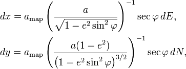
where  is geodetic latitude,
  is the first eccentricity of the ellipsoid of the Earth,
  is the semi-major axis of the Earth, and
  is that at the scale of the map as drawn (see " Geodetic system" and "Mercator projection"). Google Maps uses
Because the Mercator projects the poles at infinity, Google Maps cannot show the poles. Instead it cuts off coverage at 85.051125° north and south which is atan(sinh(π))×180/π, a requirement that the map is a square. This is not considered a limitation, given the purpose of the service.
Comparable services
- Apple Maps – Apple's map service launched in 2012 with iOS 6 to replace the Google Maps application on their phone
- Bing Maps – Microsoft's mapping service with road maps and aerial/satellite imagery
- MapQuest
- OpenStreetMap – a royalty free, editable map of the world
- Géoportail – a French rival offering detailed aerial photographs of French territories
- NearMap - Australia specific aerial photography, regularly updated.
- Nokia Maps – a service offered by Nokia that allows synchronizing with user's mobile phones
- Seat Pagine Gialle – an Italian competitor offering detailed satellite pictures of Italian territories and navigable street level panoramas of Rome (similar to Street View)
- Terralink International
- ViaMichelin
- Waze
- Yahoo! Maps
- Yandex Maps - maps by Yandex, Google's major competitor in Russia and ex-USSR