

File:Meningite.png
- File
- File usage
- Find out more
Size of this preview: 640 × 296 pixels.
| |
This is a file from the Wikimedia Commons. Information from its description page there is shown below.
Commons is a freely licensed media file repository. You can help. |
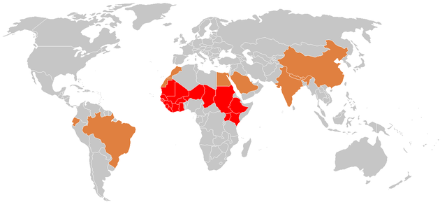
| Description | Français : Pays concernés par la méningite. Cette répartition géographique ne reflète pas entièrement le risque car tous les pays du globe sont concernés par cette maladie (à preuve les cas réguliers décrits en France par exemple). Cette carte a néanmoins le mérite de mettre en exergue la ceinture de la méningite en Afrique où tous les ans il existe une épidémie importante en fin de saison sèche.
English: Countries with reported cases of meningitis. This map does not entirely reflect the risk posed by meningitis, because there are isolated cases reported around the world each year. This map does show the epidemic "belt of meningitis" in Africa that occurs every year at the end of the dry season.
|
| Date | 27 September 2006 |
| Source |
|
| Author | Percherie |
| Permission ( Reusing this file) |
Voir ci-dessous |
- ♦ Ceinture méningitique ("Meningitis belt")
- ♦ Zones endémique (epidemic zones)
- ♦ Zones endémosporadique (sporadic cases)
Licensing
|

 |
This map image could be recreated using vector graphics as an SVG file. This has several advantages; see Commons:Media for cleanup for more information. If an SVG form of this image is already available, please upload it. After uploading an SVG, replace this template with {{ vector version available|new image name.svg}}. |
Find out more
You can learn about nearly 6,000 different topics on Schools Wikipedia. The world's largest orphan charity, SOS Children brings a better life to more than 2 million people in 133 countries around the globe. Help another child by taking out a sponsorship